Saint Paul and Amsterdam
| Saint Paul and Amsterdam | |
|---|---|
| Waters | Indian Ocean |
| Geographical location | 38 ° 16 ′ S , 77 ° 33 ′ E |
| Number of islands | 2 |
| Main island | Amsterdam island |
| Total land area | 64.5 km² |
| Residents | 35 (ward staff) |
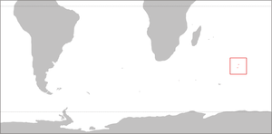
| Map of Saint Paul and Amsterdam | |
Saint Paul and Amsterdam ( French Îles Saint-Paul et Nouvelle-Amsterdam ) is a group of islands in the Indian Ocean . Politically it belongs to the territory of the French Southern and Antarctic Lands and forms the Îles Saint-Paul et Nouvelle-Amsterdam district ( INSEE code 984 11).
In 2019, the islands, as part of the French southern regions and seas , were declared a World Heritage Site by UNESCO .
geography
Sankt Paul und Amsterdam is isolated in the southern Indian Ocean on the western part of the Southeast Indian Ridge , the diverging interface between the Antarctic and Australian plates . The archipelago is located around 3370 km southwest of Western Australia , 3200 km southeast of Madagascar and around 1300 km northeast of the Kerguelen Archipelago. It consists of the two islands of Amsterdam ( Île Amsterdam , also Nouvelle Amsterdam ) and Sankt Paul ( Île Saint-Paul ), which are 92 km apart in a north-south direction. Saint Paul and Amsterdam are of volcanic origin but are currently inactive. Both islands together cover an area of 64.5 km²; the highest point is the Mont de la Dives on Amsterdam with 881 m above sea level.
history
The larger, more northerly island of Amsterdam was discovered on March 18, 1522 by Juan Sebastián Elcano on board the Victoria , the last remaining ship of Magellan's circumnavigation fleet , Saint Paul probably in 1559 by the Portuguese . The islands were taken over for France as early as 1843 by the crew of the French three- master L'Olympe under captain Martin Dupeyrat . In order not to endanger the political rapprochement with Great Britain at that time, however, King Louis-Philippe I refused to ratify the occupation. The final French occupation was only carried out in October 1892 by the scout La Bourdonnais and confirmed in January 1893 by the warship L'Eure . First assigned to the island of Réunion , then in 1924 to the colony of Madagascar, the archipelago was assigned to the newly created territory of the French Southern and Antarctic Territories ( Terres australes et antarctiques françaises, TAAF ) in 1955 . Both islands have been briefly inhabited a few times in the past; today there is no longer a permanent population. The French Polar Institute has operated a year-round research station on Amsterdam since 1949 with a crew of around 25 in winter and up to 50 in summer.
Web links
- Saint Paul and Amsterdam ( Memento of March 23, 2010 in the Internet Archive ) on the IPEV website (French)
- Bernhard Krauth: General and navigational facts about the islands (Nouvelle) Amsterdam and Saint Paul in the South Indian Ocean . 2016 (excerpts from the updated and updated version of the author's diploma thesis dated February 20, 1995).
Individual evidence
- ^ Codification des collectivités d'outre-mer (COM). Terres australes et antarctiques françaises 98-4. In: Insee - Définitions, méthodes et qualité. INSEE , accessed on May 17, 2017 (French).
- ^ French Austral Lands and Seas. UNESCO World Heritage Center, accessed July 8, 2019 .
- ^ Bernhard Krauth: General and navigational facts about the islands (Nouvelle) Amsterdam and Saint Paul in the South Indian Ocean. 2.4 Saint Paul - history of the first fishing settlement and the following period (period 1840–1925). Retrieved May 17, 2017 .
- ↑ Subantarctique - Île d'Amsterdam: Base Martin-de-Viviès. In: Institut polaire français. IPEV , accessed on May 17, 2017 (French).

