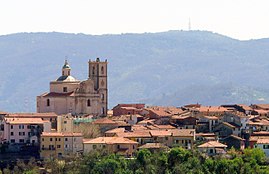
Santo Stefano di Magra
| Santo Stefano di Magra | ||
|---|---|---|

|
|
|
| Country | Italy | |
| region | Liguria | |
| province | La Spezia (SP) | |
| Coordinates | 44 ° 10 ' N , 9 ° 55' E | |
| surface | 13 km² | |
| Residents | 10,011 (Dec. 31, 2019) | |
| Population density | 770 inhabitants / km² | |
| Post Code | 19037 | |
| prefix | 0187 | |
| ISTAT number | 011026 | |
| Popular name | Santostefanesi | |
| Patron saint | Stephen | |
| Website | Santo Stefano di Magra | |
 Santo Stefano di Magra |
||
Santo Stefano di Magra (in Ligurian : San Stéva ) is an Italian municipality with 10,011 inhabitants (as of December 31, 2019) in the Liguria region . It is located in the province of La Spezia .
geography
location
Santo Stefano di Magra is located in the section of the province of La Spezia where the Vara River flows into the Magra River. The territory of the municipality extends into the surrounding hill country, as far as the district of Ponzano Superiore .
The municipality is located at a strategically important point that connects the province of La Spezia with the Tuscan province of Massa-Carrara . In addition, at Santo Stefano di Magra, important connecting roads branch off towards the province of Parma .
The municipality is located in the Montemarcello-Magra Natural Park .
Neighboring communities
The municipalities of Aulla , Bolano , Sarzana and Vezzano Ligure border on Santo Stefano .
traffic
The A12 Genoa – Rome (Autostrada Azzurra) and A15 Parma – La Spezia (Autocamionale della Cisa) highways intersect southwest of the village .
Web links
Individual evidence
- ↑ Statistiche demografiche ISTAT. Monthly population statistics of the Istituto Nazionale di Statistica , as of December 31 of 2019.

