Schaabe
The Schaabe is an almost twelve kilometer long spit on the Baltic Sea island of Rügen . It is 600 to 2000 meters wide. It lies between the Jasmund and Wittow peninsulas .
Washed up and formed by the sea, it forms the crescent-shaped boundary of the Tromper Wiek and on the other side separates the Great Jasmunder Bodden and the Breeger Bodden from the Baltic Sea . The fine, washed-up sand forms a huge natural bathing bay, which is bounded by the villages of Glowe and Juliusruh (part of the municipality of Breege ).
In contrast to the second large spit on the island of Rügen, the Schmalen Heide between Jasmund and Granitz , which was shaped by the construction of the KdF-Bad Prora and decades of military use with the associated infrastructure, the Schaabe is between Glowe and Juliusruh except for a forestry and the only continuous road as well as the adjacent paved bicycle path undeveloped.
Emergence
The Schaabe began to form around 4500 years ago when Rügen was still an island archipelago. Only the island cores, especially Wittow and Jasmund, protruded from the sea. Due to the force of the surf, combined with a sustained uplift of the land , the coasts of these island cores were gradually eroded and the sediments , reinforced by the ocean currents, were swept up to form spits. This process continues to this day.
Archaeological finds have shown that the southern part of the Schaabe in the area of today's Glowe only silted up in the time of the early Slavic settlement, i.e. in the 7th or 8th century. This also means that the seafarers from the then important Slavic settlement near today's Ralswiek - at the transition between the Great and the Small Jasmunder Bodden - had considerably shorter access to the open sea. Until 1892, when the road to Altenkirchen was being built , there was this connection inflow from the Baltic Sea to the Bodden near Glowe . The constantly silting tributary was closed with the road construction.
Similar to the flint fields in the northern part of the Schmale Heide, but to a much lesser extent, in the northern part of the Schaabe there are walls of flint in many places behind the main dune, which were thrown up by the surf here in earlier times, when the sea level was even higher . This proves that the leaching of flint stones from the chalk cliffs of Wittow and Jasmund has diminished over the centuries in favor of today's fine sandy beach.
In the 17th and 18th centuries, the Schaabe near Juliusruh was cordoned off by a fortification to prevent the north of Rügen from being conquered. The rest can still be seen today as a ground monument at the entrance to the village.
today
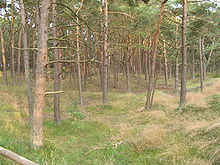
Behind the wide white beach, a ten kilometer long and up to seven meter high coastal protection dune protects the hinterland from storm floods . An elaborate planting with beach grass (Ammophila arenaria) stabilizes the dune, which counteracts the erosion by wind and sea surf and promotes height growth. Behind the main dune followed by a kleinbuckelige dunes (one to five meters above sea level ), the most recently in 1866, 1881, 1901, 1952 and 1957 with pine ( black pine ), birch , sessile oak and common oak was planted. This coastal protection forest has an area of 168 ha and extends to the southwestern shore of the lagoon. Before this reforestation, the Schaabe was also called “Narrow Wittower Heide” for centuries.
Due to the different moisture levels of the soil on the cradle and bottom side of the Schaabe, there is different vegetation on both sides.
Individual evidence
- ↑ a b Heinz Lehmann, Renate Meyer: Rügen A – Z. From Arkona to Zudar. Worth knowing in brief. Wähmann, Schwerin 1976, p. 77.
- ^ General plan for coastal and flood protection Mecklenburg-Western Pomerania. Ministry for Building, Regional Development and Environment Mecklenburg-Western Pomerania, Schwerin 1994, digitized version (PDF; 1.04 MB) ( Memento from November 7, 2007 in the Internet Archive ).
Web links
- Literature about Schaabe in the state bibliography MV
- Holiday in autumn 2003 on the German island Rügen. Part # 4: Beach at the cockroach at Glowe. - Kite Aerial Photography - aerial photos of the Schaabe.
Coordinates: 54 ° 34 ′ 52 ″ N , 13 ° 24 ′ 17 ″ E


