Shantar Islands
| Shantar Islands | ||
|---|---|---|
| Map of the Shantar Islands | ||
| Waters | Sea of Okhotsk | |
| Geographical location | 55 ° 0 ′ N , 137 ° 45 ′ E | |
|
|
||
| Number of islands | 15th | |
| Main island | Bolshoi Shantar | |
| Total land area | 2500 km² | |
| Residents | uninhabited | |
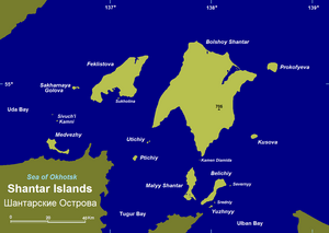
The Shantar Islands ( Russian Шантарские острова / Schantarskije ostrowa) are an archipelago in the southwest of the Sea of Okhotsk in the Far East of Russia .
The archipelago consists of 15 islands with a total area of around 2,500 km². They are separated from the coast ( Tugur Bay and Tugur Peninsula ) by narrow straits, including the Lindholm Strait, which is only four kilometers wide, between the mainland and the nearest islands. The Uda Bay extends northwest of the islands and the Academy Bay to the southeast . The sea area between the Shantar Islands and the mainland is also known as the Shantar Sea ( Шантарское море / Schantarskoje more).
The surface of the islands is mostly mountainous, the coasts steep. The islands are made of sandstone and mica schist , which have been broken through by granites and ultrabasic rocks .
The mountains are covered by larch and fir forests, the summit areas are occupied by dwarf pine - Knieholz .
Administratively, the Shantar Islands belong to the Tugur-Chumikan Raion of the Khabarovsk region . There is no permanent population in the Shantar Islands.
List of Shantar Islands
| Surname | Area (km²) |
maximum height (m) |
|---|---|---|
| Bolshoi Shantar (Great Shantar Island) | 1,766 | 720 |
| Feklistow Island | 372 | 485 |
| Maly Shantar (Small Shantar Island) | 100 | 224 |
| Belichi | 70 | 453 |
| Prokofiev Island | 40 | 638 |
| Kussow Island | 10 | 651 |
| Zecharnaya Golova | 6th | 266 |
| Yuzhny | 3 | 182 |
| Ptitschi | 3 | 239 |
| Sewerny | 1 | 134 |
| Sredni | <1 | 93 |
| Utichi | <1 | 198 |

