Scharfenberg (Klipphausen)
|
Scharfenberg
Community Klipphausen
Coordinates: 51 ° 7 ′ 10 ″ N , 13 ° 30 ′ 45 ″ E
|
|
|---|---|
| Incorporation : | January 1, 1999 |
| Postal code : | 01665 |
| Area code : | 03521 |
|
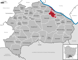
Location of the district Scharfenberg in Klipphausen
|
|

Scharfenberg is a village in the municipality of Klipphausen in the district of Meißen , Saxony .
geography

The locality Scharfenberg consists of the local part Scharfenberg itself from Batzdorf , Bergwerk , Bockwen , Gruben , Naustadt , Pegenau , Polenz , Reichenbach , Reppina , Riemsdorf and Spittewitz . These make up the northern part of the municipality of Klipphausen. The village borders on the villages of Gauernitz in the east and Klipphausen in the south. The major district towns of Meißen and Coswig border to the north .
The district of Scharfenberg is centrally located in the village of the same name. It is located in the district of Scharfenberg and includes the villages of Bergwerk, Pegenau and Reppina. In addition to the village of Reppnitz itself, the Reppnitz district also includes the village of Gruben. Several buildings in the village are protected as cultural monuments (see list of cultural monuments in Scharfenberg ).
history

In the 19th century a rural community called Gruben was established , which in addition to Reppnitz also comprised mine, Pegenau and Reppina. Scharfenberg Castle has been located on Pegenauer Flur, not far from today's Scharfenberg district, since the Middle Ages . After this, the community of Gruben was renamed Scharfenberg in 1920.
On July 1, 1950, was carried incorporation of Batzdorf, Naustadt, Reichenbach and Riems village. On April 1, 1993 there was a merger with the municipality of Bockwen-Polenz , to which Spittewitz also belonged. Since it was reunified on January 1, 1999, Scharfenberg has been part of the municipality of Klipphausen.
Population development
|
literature
- Cornelius Gurlitt : Scharfenberg. In: Descriptive representation of the older architectural and art monuments of the Kingdom of Saxony. 41. Issue: Administrative Authority Meißen-Land . CC Meinhold, Dresden 1923, p. 448.
- Balthasar Renckewitz: Draft or mining news from the mine in Scharffenberg, and its buildings, as well from the old ones as where they were built… . Leipzig 1745.
- H. Müller: About the Scharfenberg mining and its resumption . In: Yearbook for the miner and hut man to the year 1854. Freiberg o. J. (1854), pp. 235–268.
- Heinrich Zinkeisen: About the veins of God's goodness to Scharfenberg. In: Yearbook for mining and metallurgy in the Kingdom of Saxony to the year 1890, pp. 40–64.
- Werner Barth: 800 years of Scharfenberg silver mining. Meißner Heimat, special issue 2, 1963, pp. 24–36.
- Holger Sickmann: The historical silver mining in Scharfenberg. In: Scharfenberger Heimatblätter. Local history information 3. OJ (1998), pp. 6-17.
- Yves Hoffmann: Scharfenberg and the Scharfenberg silver mining in the Middle Ages . In: Mitteilungen des Freiberg Altertumsverein 98, 2006, pp. 15–38.
Web links
- Scharfenberg (Klipphausen) in the Digital Historical Directory of Saxony
- Scharfenberg district on the website of the municipality of Klipphausen


