
Schernfeld
| coat of arms | Germany map | |
|---|---|---|

|
Coordinates: 48 ° 54 ' N , 11 ° 6' E |
|
| Basic data | ||
| State : | Bavaria | |
| Administrative region : | Upper Bavaria | |
| County : | Eichstatt | |
| Management Community : | Eichstatt | |
| Height : | 548 m above sea level NHN | |
| Area : | 52.24 km 2 | |
| Residents: | 3272 (December 31, 2019) | |
| Population density : | 63 inhabitants per km 2 | |
| Postcodes : | 85132, 85072 | |
| Primaries : | 08422, 08421 | |
| License plate : | EGG | |
| Community key : | 09 1 76 160 | |
| LOCODE : | DE CED | |
| Community structure: | 13 parts of the community | |
| Association administration address: | VG Eichstätt Gundekarstr. 7a 85072 Eichstätt |
|
| Website : | ||
| Mayor : | Ludwig Mayinger ( CSU ) | |
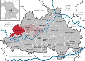
| Location of the municipality of Schernfeld in the district of Eichstätt | ||
  |
||

Schernfeld is a municipality in the Upper Bavarian district of Eichstätt and, together with the municipalities of Pollenfeld and Walting, forms the Eichstätt administrative community .
geography
Schernfeld is located on the plateau of the Franconian Alb six kilometers northwest of Eichstätt.
Community structure
The municipality has 13 officially named municipality parts (the type of settlement is indicated in brackets ):
|
|
Neighboring communities
| Weißenburg in Bavaria | Raitenbuch | Pollen field |
|
Pappenheim Solnhofen |
.svg)
|
Eichstatt |
| Mörnsheim | Dollnstein |
history
Until the church is planted
During the witch hunt in the Hochstift Eichstätt , at least two women from Schernfeld and Langensallach were accused as alleged witches and sentenced to death in 1617 and 1618 respectively.
The office of the Hochstift Eichstätt belonged to the Franconian Empire from 1500 and fell in the Reichsdeputationshauptschluss 1803 with the largest part of the Hochstift area to the Principality of Eichstätt of the Archduke Ferdinand of Tuscany . Since the Peace of Pressburg in 1805, the place, like large parts of Franconia, has belonged to Bavaria (see also the history of Franconia ).
The municipality part of Birkhof was first mentioned in 1186 as Birchach .
District assignment
With the territorial reform , the municipality came on July 1, 1972 with the district of Eichstätt from Middle Franconia to Upper Bavaria.
Incorporations
On January 1, 1971, the previously independent communities of Sappenfeld, Schernfeld, Schönau and Schönfeld were merged to form the new community of Schernfeld. Workerszell was added on May 1, 1978.
Population development
Between 1988 and 2018 the municipality grew from 2,288 to 3,197 by 909 inhabitants or 39.7%.
- 1961: 1904 inhabitants
- 1970: 1981 inhabitants
- 1987: 2229 inhabitants
- 1991: 2572 inhabitants
- 1995: 2778 inhabitants
- 2000: 2968 inhabitants
- 2005: 3118 inhabitants
- 2010: 3027 inhabitants
- 2015: 3155 inhabitants
politics
Municipal council
The municipal council of Schernfeld has 16 members:
- CSU / Citizen List 7 seats
- FREE VOTERS / Free Christian Voters Community (FREE VOTERS / FCWG Schernfeld) 9 seats
(Status: local election on March 15, 2020 )
mayor
Bauer Stefan (FREIE VÄHLER / FCWG Schernfeld) has been the mayor since May 1, 2020.
coat of arms
The coat of arms was approved on November 15, 1985 by the government of Upper Bavaria.
Blazon : "Under the split shield head, in the front in silver a continuous red bar cross, in the back a silver flaming sword and a silver arrow crossed diagonally in blue, in red a silver ammonite."
In the center of the coat of arms there is an ammonite - the fossilization of a species of mollusc that lived around 150 million years ago - as a reference to the numerous fossil finds in the Jurassic quarries of the municipality on the heights of the Eichstätter Alb; Many of these finds are exhibited in the Harthof Museum. The head of the shield symbolizes the church patronage in the municipality: the cross stands for St. Georg in Schernfeld, the arrow for St. Sebastian in Sappenfeld and for St. Egidius in Schönfeld, and the flaming sword for St. Michael in Rupertsbuch. The red and silver coloring is reminiscent of the former territorial rule of the Eichstätt Monastery, the blue and silver of the Rebdorf monastery, which was historically important as a landowner for the municipality.
The coat of arms was designed by the heraldist Theodor Goerge from Freising .

- Schernfeld : In addition to the parish church of St. Georg, a new building from the 1950s, the old water tower dominates the townscape.
- Schönfeld : The time of construction of the Church of St. Giles is not known. The choir and tower were built in the late 17th century, the nave was extended in 1860; In the course of this renovation, the originally baroque church became neo-Romanesque . Master Jakob Meisler from Dollnstein built the high altar in 1726 , reusing the old altar sheet; In 1738 he added two new side altars. The altar leaves and two scholarships were painted by the Eichstatt artist Martin Zwicklein (Zwickl). The village has a baroque parsonage built in 1778 by the Eichstatt court architect Maurizio Pedetti .
- Schönau : local chapel of the Assumption of Mary
Architectural monuments
Economy and Infrastructure
Economy including agriculture and forestry
The municipal tax revenue in 1999 amounted to the equivalent of € 1,069,000, of which the equivalent of € 220,000 (net) was trade tax income.
In 1998, according to official statistics, there were six in the field of agriculture and forestry, 221 in the manufacturing sector and 50 in the trade and transport sector at the place of work. In other economic sectors 58 people were employed at the place of work subject to social security contributions. There were a total of 957 employees at the place of residence subject to social security contributions. There were none in the manufacturing sector and seven in the construction sector. In addition, in 1999 there were 94 farms with an agricultural area of 2547 hectares, of which 1926 hectares were arable land and 620 hectares were permanent green space.
Forest adventure center Schernfeld
The Schernfeld Forest Experience Center is a facility of the Office for Food, Agriculture and Forests Ingolstadt , Forsten branch in Eichstätt. It was launched in 1997, and the offices are located in the historic forestry office building in Schernfeld. In 2004, the newly built Schönwieselhaus in the Schernfelder Forest was inaugurated by Minister of State Miller. There is a historic wolf pit in very good condition near the Schönwieselhaus . So far, two courses (the adventure course and the nature discovery tour) have been created for forest visitors. A third way, especially for the disabled, has been in use for a number of years.
education
In 2012 the following institutions existed:
- four day-care centers with 142 places and 96 children
- an elementary school in Schernfeld with nine teachers and 133 students
- Forest adventure center Schernfeld
- Regular events of the Catholic educational organization in the Eichstätt district in Schernfeld and Schönfeld
Personalities
- Xaver Bittl (* 1943 in the Sappenfeld district), politician (CSU), former Eichstätt district administrator
- Anna Knauer (* 1995), racing cyclist
Web links
- Entry on the coat of arms of Schernfeld in the database of the House of Bavarian History
- Website of the community of Schernfeld
- List of monuments in the municipality
- Schernfeld: Official statistics of the LfStat
Individual evidence
- ↑ "Data 2" sheet, Statistical Report A1200C 202041 Population of the municipalities, districts and administrative districts 1st quarter 2020 (population based on the 2011 census) ( help ).
- ^ VG in a new building. Eichstätter Kurier , November 16, 2016, accessed on January 2, 2017 .
- ^ Community of Schernfeld in the local database of the Bavarian State Library Online . Bavarian State Library, accessed on September 14, 2019.
- ↑ E. Weis: The foundation of the modern Bavarian state (1799-1825). In: The new Bavaria: State and politics. From 1800 to the present. ed. by Alois Schmid, second edition, Munich 2003, pp. 4–128, here: p. 23
- ^ Wilhelm Volkert (ed.): Handbook of Bavarian offices, communities and courts 1799–1980 . CH Beck, Munich 1983, ISBN 3-406-09669-7 , p. 456 .
- ^ Federal Statistical Office (ed.): Historical municipality directory for the Federal Republic of Germany. Name, border and key number changes in municipalities, counties and administrative districts from May 27, 1970 to December 31, 1982 . W. Kohlhammer, Stuttgart / Mainz 1983, ISBN 3-17-003263-1 , p. 599 .
- ^ Bavarian State Office for Statistics. Retrieved August 16, 2018 .
- ↑ http://gemeinde-schernfeld.de/einrichtungen/kindergaerten-kita/
- ^ A sense of achievement shortly before the end of the year , Donaukurier from December 22, 2015
Birkhof | Ferdinandsfeld | Railing | Harthof | Langensallach | Lohrmannshof | Ruperts book | Sappenfeld | Schernfeld | Schönau | Schönfeld | Sperberslohe | Workerszell

Adelschlag | Altmannstein | Beilngries | Böhmfeld | Buxheim | Denkendorf | Dollnstein | Egweil | Eichstätt | Eitensheim | Gaimersheim | Großmehring | Hepberg | Hitzhofen | Kinding | Kipfenberg | Koesching | Lenting | Mindelstetten | Mörnsheim | Nassenfels | Oberdolling | Pförring | Pollen field | Schernfeld | Stammham | Titting | Walting | Wellheim | Wettstetten
Non-parish areas in the Eichstätt
Haunstetter Forst district