
Seewen SO
| SO is the abbreviation for the canton of Solothurn in Switzerland and is used to avoid confusion with other entries of the name Seewen . |
| Seewen | |
|---|---|
 |
|
| State : |
|
| Canton : |
|
| District : | Dorneck |
| BFS no. : | 2480 |
| Postal code : | 4206 |
| UN / LOCODE : | CH SWE |
| Coordinates : | 616.68 thousand / 253947 |
| Height : | 544 m above sea level M. |
| Height range : | 423–897 m above sea level M. |
| Area : | 16.31 km² |
| Residents: | 1010 (December 31, 2018) |
| Population density : | 62 inhabitants per km² |
| Website: | www.seewen.ch |
 Village center |
|
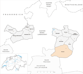
| Location of the municipality | |
  |
|
Seewen (in dialect: Seebe ) is a municipality in the district of Dorneck in the canton of Solothurn in Switzerland .
geography


Seewen lies at 544 m above sea level. M. , 15 km south-southeast of the city of Basel (linear distance). The community extends at the eastern end of a wide flat area of the Seetel through which the Seebach flows, south of the plateau of the Gempenplateau , in the Schwarzbubenland .
With an area of 16.4 km², Seewen is the largest municipality in the Dorneck district. The municipality covers a section of the northern Jura and has a great variety of landscapes. Geologically, Seewen is located in the transition zone from the Tabular Jura to the Folded Jura , which here was pushed far beyond the unfolded layers. The area is drained from the Seebach to the Birs . This initially flows from south to north and is dammed above Seewen in the Baslerweiher , a pond created in 1870 by the Basel waterworks. At Seewen the brook draws a sharp bend to the west and flows through a 2 km long and up to 500 m wide plain. Due to a landslide that occurred in prehistoric times around 13,000 years ago, the former valley near Fulnau was sealed off and the creek dammed into a lake ( Seewener See ), which had an underground drainage due to the loose landslide material. The gradually silting lake was diverted in 1588 and the soil was later meliorated . Part of the Sertel to the west of the landslide area , a deep valley between the (Himmelrieder) Homberg and the Eichenberg , also belongs to Seewen. To the north of the Seebach valley, the municipality extends to the height of the Gempen plateau (up to 690 m above sea level ).
The southern part of the municipality is occupied by the Chain Jura, a strongly reliefed landscape with a series of hills, valleys and hollows. While the heights are predominantly forested, the basin layers are meadowland; Larger clearing islands were created around the individual farms . This part is subdivided by the valleys of the Seebach and the Homberggraben, which run from south to north . To the east of the Seebach are the Bettenberg ( 758 m above sea level ), the Holzenberg ( 756 m above sea level ) and the Strick ( 732 m above sea level ). The Buchenberg ( 705 m above sea level ) and the Rechtenberg ( 788 m above sea level ) rise between the Homberggraben and the Seebachtal . To the west of the Homberggraben are the Homberg (at 897 m above sea level, the highest point in Seewen) and the ridge of the (Himmelrieder) Homberg (up to 756 m above sea level ), with the Neumatt hollow in between . This valley basin is drained in the extreme southwest through the Igraben to the Chastelbach (right bank of the Birs). The Imberg with its rocky crest still belongs to Seewen. In 2014, 6% of the municipal area was in settlements, 53% in forests and woodland, 40% in agriculture and a little less than 1% in unproductive land.
Numerous individual farms belong to Seewen. Neighboring communities of Seewen are Hochwald , Büren (SO) , Nunningen and Himmelried in the canton of Solothurn and Ziefen , Reigoldswil , Bretzwil and Duggingen in the canton of Basel-Landschaft .
population
With 1010 inhabitants (as of December 31, 2018) Seewen is one of the medium-sized communities in the canton of Solothurn. 95.1% of the residents are German-speaking, 0.8% Italian-speaking and 0.7% French-speaking (as of 2000). The population of Seewen was 933 in 1850, compared to 762 in 1900. During the 20th century, the population fluctuated in the range between 740 and 870 people. Only since 1980 (738 inhabitants) has a significant increase in population been recorded.
politics
The local council (executive) consists of 5 members including the mayor. The seats were distributed as follows:
| Political party | 2013-2017 | (+/-) | 2009-2013 |
|
FDP. The Liberals ( Free Democratic Party until 2009 ) |
3 | 3 | |
| Christian Democratic People's Party | 2 | 2 |
economy
Until the second half of the 20th century, Seewen was a village dominated by agriculture . Today there are mainly jobs in local small and medium-sized businesses and in the service sector, including in companies in the construction industry, wood processing and in the Swiss National Museum for music machines. In the last few decades Seewem has developed into a residential community. Many employees are therefore commuters who work mainly in the Basel area and the Liestal region. The real estate market has grown strongly since 2002. From 2004, a particularly large number of new buildings were built in Seewen.
traffic
Seewen is close to the major motorways between Delémont, Basel, Laufen, Liestal and is easily accessible with three major connecting roads. Postbuses run every 45 minutes to Büren (Liestal), Hochwald (Dornach), Grellingen BL (Basel) and Bretzwil BL (Laufen).
history
The first written mention of the place took place in 1147 under the name Sewin ; from 1194 the name Sewen has been handed down. The place name goes back to the Old High German word sêo (lake); sewin is a dative form and means for lakes .
The Seewen church set has belonged to Beinwil Monastery since it was first mentioned . Secular rights over the village were incumbent on the Counts of Thierstein , who ceded them to the Lords of Ramstein in 1317 . A family dispute over the legal claims to Seewen ended in 1460 with the devastation and pillage of the village by the "journeymen of Olten ". Shortly afterwards, in 1462, Seewen was pledged to Solothurn, which in 1484 acquired the entire village and subsequently assigned it to the bailiwick of Dorneck and the district of Ob dem Berg.
During the Swabian War , Seewen was badly affected by imperial troops. When a tunnel was pierced through the landslide area of Fulnau in 1588, the Seewener See was diverted, but what remained was a swampy landscape because the drainage channel was too high. After the collapse of the Ancien Régime (1798), Seewen belonged to the Dornach district during the Helvetic Republic and to the Dorneck district from 1803. From 1919 to 1923, was eventually comprehensive amelioration of bog soil made to the site of the former lake and valuable farmland won.
At Pentecost 1976, the Seewen murder occurred , one of the largest and so far unsolved crimes in Swiss criminal history: five people were shot at the weekend house "Waldeggli".
Attractions
The Sankt German church stands in a dominant position on a ledge above the village. The church received its present form during the extensive renovation, enlargement and redesign in 1823. At that time the double-towered complex was built; the hooded helmets of the two towers were later replaced by pointed helmets , but were given their original shape again in 1973 by the Seewen-based company T&T Schmidli Holzbau GmbH. Characteristic farmhouses from the 17th to 19th centuries have been preserved in the town center.
The Museum for Music Automatons , a museum of the Swiss Confederation, has been in Seewen since 1979 with a collection of Swiss music boxes, record boxes and other mechanical musical instruments.
photos

Church of St. German

school

Row of houses


coat of arms
- Divided by a wavy line by red with a white six-pointed star, separated by two green-leafed black reed cobs and by white with a blue fish swimming to the right
Personalities
- Martin Disler was born in Seewen
- Heinrich Weiss was accepted as an honorary citizen in Seewen in 1990
literature
- Gottlieb Loertscher: The art monuments of the canton of Solothurn, Volume III: The districts of Thal, Thierstein, Dorneck. (= Art Monuments of Switzerland. Volume 38). Edited by the Society for Swiss Art History GSK. Bern 1957, DNB 750089342 .
Web links
- Official website of the Seewen municipality
- Lukas Schenker: Seewen (SO). In: Historical Lexicon of Switzerland .
Individual evidence
- ↑ Permanent and non-permanent resident population by year, canton, district, municipality, population type and gender (permanent resident population). In: bfs. admin.ch . Federal Statistical Office (FSO), August 31, 2019, accessed on December 22, 2019 .
- ↑ s'Seebner Dorfblatt - Number 2 / Volume 24: term of office 2013 - 2017; Results of the renewal elections (page 4; PDF; 1.6 MB)
- ↑ Municipality of Seewen SO minutes of the municipal meeting (page 2; PDF; 597 kB)