Seja (river)
|
Seja Zея |
||
|
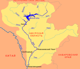
Catchment area of the Seja (Зея) with tributaries |
||
| Data | ||
| Water code | RU : 20030400112118100022394 | |
| location | Amur Oblast ( Russia ) | |
| River system | Amur | |
| Drain over | Amur → Tatar Sound | |
| source |
Stanowoy Mountains 55 ° 55 ′ 57 ″ N , 130 ° 23 ′ 20 ″ E |
|
| muzzle |
Amur coordinates: 50 ° 14 ′ 28 " N , 127 ° 36 ′ 0" E 50 ° 14 ′ 28 " N , 127 ° 36 ′ 0" E
|
|
| length | 1242 km | |
| Catchment area | 233,000 km² | |
| Discharge at the Blagoveshchensk gauge |
MNQ MQ MHQ |
1.5 m³ / s 1800 m³ / s 14,200 m³ / s |
| Left tributaries | Selemdscha , Tom , Kupuri , Argi , Dep , Urkan | |
| Right tributaries | Giljui , Urkan , Tok , Mulmuga , Brjanta | |
| Reservoirs flowed through | Seja dam | |
| Big cities | Blagoveshchensk | |
| Medium-sized cities | Seja , Svobodny | |
| Communities | Novokievsky Uwal | |
|
Seja near Blagoveshchensk |
||
The Seja ( Russian Зея ) is a left tributary of the Amur in the Amur Oblast in the Far East of Russia .
It rises in the eastern part of the Stanowoigebirges flows from there initially to the southwest and the north of the city Seja location Seja dam . Then it turns south, finally flowing into the Amur at Blagoveschensk . The length of the Seja is 1242 km. The catchment area covers 233,000 km². The mean discharge at the mouth is 1910 m³ / s. The Seja is frozen over from November to May. Its greatest inflow is the Selemdscha .
Web links
Commons : Seja - collection of images, videos and audio files
Individual evidence
- ↑ a b c Article Seja (river) in the Great Soviet Encyclopedia (BSE) , 3rd edition 1969–1978 (Russian)
- ↑ a b Seja (river) in the State Water Directory of the Russian Federation (Russian)
- ↑ http://www.abratsev.narod.ru/biblio/sokolov/p1ch24b.html Sokolov, Far East // Hydrography of USSR. (In russian)


