Selenga
|
Selenga Селенга, Сэлэнгэ (Selenge) |
||
|
The Selenga catchment area |
||
| Data | ||
| Water code | RU : 16030000512116300006917 | |
| location |
Chöwsgöl , Bulgan , Selenge , ( Mongolia ); Republic of Buryatia ( Russia ) |
|
| River system | Yenisei | |
| Drain over | Angara → Yenisei → Arctic Ocean | |
| source | Confluence of the Delgermörön and Ider rivers in northern Mongolia 49 ° 15 ′ 43 ″ N , 100 ° 40 ′ 47 ″ E |
|
| Source height | approx. 1176 m | |
| muzzle |
Lake Baikal near Selenginsk Coordinates: 52 ° 16 ′ 0 ″ N , 106 ° 29 ′ 0 ″ E 52 ° 16 ′ 0 ″ N , 106 ° 29 ′ 0 ″ E |
|
| Mouth height | approx. 456 m | |
| Height difference | approx. 720 m | |
| Bottom slope | approx. 0.7 ‰ | |
| length | approx. 1024 km | |
| Partial lengths | approx. 615 km in Mongolia
|
|
| Catchment area | approx. 447,060 km² | |
| Discharge at the Naushky A Eo gauge : 282,000 km² Location: 402 km above the mouth |
MQ 1936-1997 Mq 1936-1997 |
364 m³ / s 1.3 l / (s km²) |
| Discharge at the Kabansk A Eo gauge : 445,000 km² Location: 43 km above the mouth |
MQ 1970-1997 Mq 1970-1997 |
934 m³ / s 2.1 l / (s km²) |
| Left tributaries | Dsulegtiin , Egiin , Jida , Temnik , Bajan , Orongoi | |
| Right tributaries | Chanui , Altatyn , Orkhon , Chikoy River , Khilok , Uda , Itantscha | |
| Big cities | Ulan-Ude | |
| Navigable | from Süchbaatar | |
|
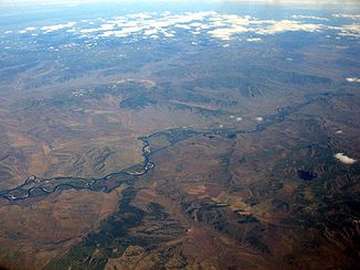
Selenga with side arms from an airplane; View approximately to the north |
||


The river Selenga or Selenge ( Mongolian Сэлэнгэ Selenge, Russian Селенга Selenga) arises in Mongolia from the confluence of the Ider and Delger mörön and flows to Russia . With a length of about 1024 km it is by far the longest and with an average discharge (MQ) of around 935 m³ / s the most water-rich tributary of Lake Baikal ( Inner Asia ). From a hydrological point of view , it is the actual upper reaches of the Angara .
With around 615 km of flow within Mongolia, it is the fifth longest river in the country, the remaining 409 km are in Russia. Together with the 452 km long source river Ider results in a length of 1476 km.
geography
course
The Selenga arises in northern Mongolia in the southern part of the Chöwsgöl Aimag around 375 km southwest of the southwest end of Lake Baikal and around 150 km (as the crow flies ) north of the center of the Changai Mountains . Its origin is the confluence of the Ider , which comes from the south , about 1.5 km after the influence of the Tschuluut Gol , and the Delgermörön coming from the northwest , about 9.5 km after the confluence of the Bügsiin, at an altitude of about 1176 m .
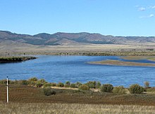
The Selenga flows in a predominantly east-northeast direction in a valley that is 20 to 25 kilometers wide through northern Mongolia. The course of the river is particularly branched out in the area of inland deltas .
First the Selenga flows east-northeast, then, between Ich-Uul ( 1058 m ) and Chutag-Öndör, to the east. Along the next section, which was also Selenge (also in Bulgan Province ) and, at the Bayou Selengiin-Taturaga , Dsüünbüren and Sükhbaatar (both in Selenge Province ) lie, rise in the north the Buteliin -Gebirge and to the south the Burengiin -Mountains. Above the village of Selenge, the water-rich Egiin Gol flows in from the north-west, which comes from the Chöwsgöl Lake from a barely touched, wooded area and is known for its stable Taimen (largest salmon fish species) occurrence .
Below Sükhbaatar flows as far longest tributary of coming from the south Orkhon , he reached over his tributary Tuul a length of around 1580 km. From now on, the river will be accompanied in sections to the north by the Trans-Mongolian Railway coming from the Orkhon Valley .
After 615 kilometers of flow in Mongolia, the Selenga crosses the state border below Süchbaatar and runs a further 409 kilometers through the Russian Republic of Buryatia .
Past Nauschki , the Selenga flows north-northeast to Choronchoi , after which the first bridge of the Trans-Mongolian Railway crosses the river before Ust-Kjachta . Further north, after the confluence of Jida and Temnik, roughly from the west, the railway line temporarily leaves the river to run along Lake Gusinoje, a few kilometers west of the Selenga . After the confluence of the bayan coming from this lake and the Chikoi flowing in from the south, the Novoselenginsk river passes .
A little further north-northeast, Chilok from the south and Orongoi from the west flow in , after which the Trans-Mongolian Railway again runs along the river. The Selenga then passes a “shaman's rock ” below Gansurino , and a little further north at Kardon another bridge of the railway line crosses the river.
Further to the northeast, the Selenga reaches the city of Ulan-Ude, the largest city on the river, where the Trans-Mongolian Railway leaves the river and connects to the Trans-Siberian Railway that will accompany the river . The Uda flows into the city from the east .
Thereafter, the Selenga flows between the mountains Chamar-Daban in the west and Ulan-Burgasy in the northeast, where the Trans-Siberian Railway crosses, first to the north, then at Tataurowo to the west and when leaving both mountains at Selenginsk to the northwest; the railway line leaves the river in the west.
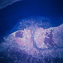
A few kilometers below Selenginsk, the Selenga divides into numerous river arms of different sizes at the beginning of its estuary delta and then reaches the southwest part of Lake Baikal, which is about 456 m above sea level.
Selenga estuary delta
The approximately 680 km² large Selenga estuary , which is located on the southern shore of Lake Baikal, has advanced around 15 km into the lake over the course of millions of years due to the rich sediment load of the river, with the delta filling reaching a thickness of 870 meters.
The delta is a resting and breeding place as well as a place of foraging for numerous water bird species. In spring and autumn there are between 4 and 7 million migratory birds that catch fish , crabs , insects and other animals. These include ospreys , golden eagles , nuns cranes , Gluck ducks , plovers , bitterns , gulls , swans , sparrows and storks (including black storks ). In addition, the rare Baikal seal , the small crab Epischura and the salmon-like Omul live on and in the delta , which is only found in Lake Baikal and in the waters adjacent to the lake. In addition , the Baikal sturgeon spawns in the Selenga .
Catchment area, headwaters and tributaries
Catchment area
The catchment area of the Selenga is 447,060 km², of which 299,000 km² are in Mongolia and 148,060 km² in Russia; it covers over 80% of the Lake Baikal catchment area. Most of the water (54%) comes from the Russian part. The economic core of Mongolia lies particularly in the sub-catchment area of the Orkhon, in which around 67% of the population lives on around 19% of the national territory.
Source rivers
The source rivers of the Selenga are - with longitude and mean discharge (MQ):
Mongolia:
- Delgermörön - left and northwestern source river (445 km, 33 m³ / s)
- Ider - longest, right or southwestern source river (452 km, 57 m³ / s)
Tributaries
The tributaries of the Selenga include - with (if known) length and mean discharge (MQ) - viewed downstream:
Mongolia:
- Dsulegtiin - left and north-northwest tributary
- Chanui - right and south tributaries
- Altatyn - right and south tributaries
- Egiin - left or northwest tributary (535 km, over 100 m³ / s)
- Orkhon - right and south tributaries (1124 km, 96 m³ / s)
Russia:
- Jida - left and west tributaries (567 km, 74 m³ / s)
- Temnik - left and west tributaries
- Bajan - left and northwest tributaries
- Tschikoi - right and southeast tributary (769 km, 274 m³ / s)
- Chilok - right and southeast tributary (840 km, 98 m³ / s)
- Orongoi - left and west tributaries
- Uda - right and east tributaries (467 km, 67 m³ / s)
- Itantscha - right and northeast tributary
Localities
At or near the Selenga are, among others, these villages - viewed downstream:
Mongolia:
- Ich-Uul in the Chöwsgöl-Aimag
- Chutag-Öndör in the Bulgan-Aimag
- Selenge in the Bulgan Aimag
- Dsüünbüren in the Selenge Aimag
- Sükhbaatar in Selenge Province - mainly in the lower reaches of the inflow Orkhon
Russia (all in the Republic of Buryatia ):
Average discharge ( m³ / s ) at the gauge near Kabansk (1978 to 1997)

|
Ice drift, runoff regime and navigability
From November to April or mid-May, the Selenga is covered in ice. The long glaciation causes a strongly fluctuating discharge regime with discharge peaks in the time of the snowmelt. At Ust-Kjachta, the average water flow in February is 107 m³ / s and 2203 m³ / s in August. The annual mean discharge (MQ) is 933.814 m³ / s. The Selenga is navigable from Süchbaatar.
History and exploration
E. I. Beliajewa first identified the genus Coelodonta tologoijensis as the slender forerunner of the woolly rhinoceros in 1966 in Tologoi (Buryatia, Russia) on the Selenga in deposits around 750,000 years old .
On the Selenga there is the Ivolginsk ring wall settlement, an important site of the Xiōngnú , a tribal union of equestrian nomads who lived there between the 3rd century BC. BC and the 4th century AD lived. On its lower reaches was once the settlement area of the Merkites (12th to 13th centuries), a Mongolian tribe from the era of Genghis Khan . In addition, the early Turkish tribal confederation Oghusen originally settled on the Selenga.
The Polish-Russian geographer, geologist, palaeontologist and explorer Iwan Tscherski (1845-1892), who also explored the catchment area of the Angara downstream from Baikal , also examined the areas of Selenga and Lower Tunguska from 1881 to 1882 .
Web links
Individual evidence
- ↑ a b c d Selenga in the State Water Register of the Russian Federation (Russian)
- ↑ a b c d e f Селенга (Selenga) in the Great Soviet Encyclopedia (Russian; accessed December 2, 2015)
- ↑ a b c d e f Project funding application ( Memento of the original from May 27, 2011 in the Internet Archive ) Info: The archive link has been inserted automatically and has not yet been checked. Please check the original and archive link according to the instructions and then remove this notice. (PDF; 1.6 MB) Global Environment Facility, 2010
- ↑ Selenga at the Naushky gauge - hydrographic data from R-ArcticNET
- ↑ a b c d e Selenga at the Kabansk gauge - hydrographic data from R-ArcticNET
- ↑ Werner Elstner: Mongolei , p. 15. Berlin 1993


