Springbok
| Springbok | ||
|---|---|---|
|
|
||
| Coordinates | 29 ° 40 ′ 0 ″ S , 17 ° 53 ′ 0 ″ E | |
| Basic data | ||
| Country | South Africa | |
| North Cape | ||
| District | Namakwa | |
| ISO 3166-2 | ZA-NC | |
| local community | Nama Khoi | |
| height | 942 m | |
| surface | 37.6 km² | |
| Residents | 12,790 (2011) | |
| density | 340.5 Ew. / km² | |
| founding | 1862 | |
Springbok (founded as Springbokfontein ) is the supply center of Namaqualand in the municipality of Nama Khoi , Namakwa District , Northern Cape Province in South Africa . Springbok is the district capital of Namakwa. The city got its name after the large springbok herds that roamed this area in the 19th century, until they were almost exterminated by the settlers. In 2011 the city had 12,790 inhabitants.
location
The city is spread over several hills, directly on the national road N7 , which connects Cape Town (550 kilometers south) and Namibia's capital Windhoek (900 kilometers north). The border crossing on the Orange River is located at Vioolsdrif on the South African and Noordoewer on the Namibian side, 120 kilometers north of Springbok.
history
The history of the city is shaped by mining. The first European expedition to this part of the Cape Colony was led in 1685 by Simon van der Stel , the first governor of the Cape Colony. He had heard reports of the rich copper deposits in this area, as well as the legends of the legendary empire of Munhumutapa , "somewhere in the north".
Van der Stel camped five kilometers east of what is now Springbok, at a point where he made three test wells. The largest of the drilling shafts on which he left his initials has been declared a national monument and a tourist attraction. Van Der Stel sent scouts to the western Atlantic coast to look for a suitable port for the ships that would later transport the copper away. However, he only received reports that the coastline was so smooth and flat that there were no usable bays or accesses.
The first large copper mine started operations in 1852. The owners of the Melkboschkuil farm , the Cloete family, sold the land to the operators Philips & King. The city was founded under the name Springbokfontein (German: "Springbockquelle") in 1862. Around 1880, rich copper deposits were discovered further north near Okiep , thanks to the year-round drinking water spring Springbok became the center for supplying miners in the entire region.
climate
Springbok has very little rainfall year-round with less than 25mm per month. In the months of December to March, the highest mean maximum values of over 30 ° C are reached, the lowest temperatures are then still over 15 ° C. It is cooler during the months of June to August: The maximum daily values are then on average just under 20 ° C, the average daily low values are around 6 ° C to 7 ° C.
tourism
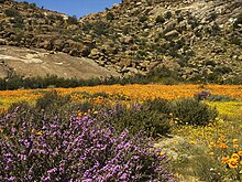
Springbok has accommodations in all price ranges. During the desert bloom, in August / September, the accommodations are usually booked out well in advance.
Attractions
- Goegap Nature Reserve , about 15 kilometers east of the city towards the airport.
- Namaqua National Park , near Kamieskroon, around 50 kilometers south of Springbok. Part of the national park is the former Skilpad Wild Flower Reserve, known to flower lovers .
sons and daughters of the town
- Esther Brand (1922-2015), track and field athlete
Web links
- Detailed history of the region (PDF file, English; 174 kB)
Individual evidence
- ↑ 2011 census , accessed November 18, 2013


