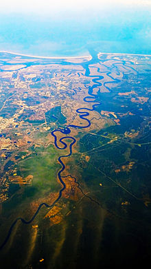
St. Marys River (Florida / Georgia)
| St. Marys River | ||
| Data | ||
| Water code | US : 306327 | |
| location | Florida / Georgia border , USA | |
| River system | St. Marys River (Florida / Georgia) | |
| source |
Okefenokee Swamp 30 ° 25 ′ 24 ″ N , 82 ° 12 ′ 32 ″ W. |
|
| muzzle | in the Atlantic Coordinates: 30 ° 43 ′ 22 ″ N , 81 ° 30 ′ 6 ″ W 30 ° 43 ′ 22 ″ N , 81 ° 30 ′ 6 ″ W
|
|
The St. Marys River is a river in the United States . From its source, the Okefenokee Swamp , to its mouth in the Atlantic Ocean, it marks the border between the states of Florida and Georgia . It is 203 km long.
Shortly before the mouth of the river lies the eponymous city of St. Marys on the left bank . From here there is a ferry connection to the offshore island of Cumberland Island .
Web links
Commons : St. Marys River - Collection of Images, Videos, and Audio Files

