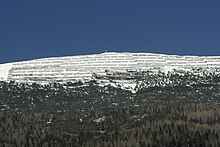
Stanser yoke
| Stanser yoke | ||
|---|---|---|
|
The Stanser Joch from the south ( Kellerjoch ) |
||
| height | 2102 m above sea level A. | |
| location | Tyrol , Austria | |
| Mountains | Rough Knöll branch , Karwendel | |
| Dominance | 1 km → Ochsenkopf | |
| Notch height | 30 m ↓ saddle to the Ochsenkopf | |
| Coordinates | 47 ° 23 '58 " N , 11 ° 41' 56" E | |
|
|
||
| rock | Wetterstein lime | |
The Stanser Joch is a mountain in the Karwendel in the Austrian state of Tyrol .
The Stanser Joch is an inconspicuous summit on the elongated ridge that runs eastwards from the Ochsenkopf 1400 meters away ( 2148 m above sea level ). The name Stanser Joch does not only refer to the inconspicuous 2102 m above sea level. A. high elevation, but the whole flat ridge. The mountain lies between the Weißenbachtal in the north and the Stallental and Inntal in the south. The Stanser Joch forms the eastern end of the Rauer Knöll branch east of the Hinterautal-Vomper chain .
While the Stanser Joch drops to the south with relatively evenly sloping slopes, it breaks off sharply towards the Weißenbachtal. On the south side a road leads to the Hochleger of the Stanser Alm ( 1961 m above sea level ) and on to the avalanche barriers at about 2000 m above sea level. A. The rest of the way to the summit cross can be covered without difficulty via steep trails.
geology
The Stanser Joch is formed from an inverted vault made of Wetterstein limestone. The vault axis runs in a west-east direction a little south parallel to the summit ridge. Also worth mentioning are still glacial striations that the glacial Inn Glacier has caused who has covered another 100 meters at times of its high in the summit. A glacier cut is exposed at the Stanser Alm-Niederleger ( 1355 m above sea level ).
The Stanser Joch has also acquired geological and historical importance. In 1868, Adolf Pichler discovered that on the top of the Stanser Joch vault there are furrows that are far older than that. Otto Ampferer interpreted Pichler's discovery as a shift in relief , that is, a thrust of rock packages over a landscape that has already been formed by erosion. With this, Ampferer recognized erosion as an important factor in tectonics . Today, Ampferer's relief displacement in this area is no longer seen as such, but rather as the result of a southwestern backward displacement in the Tertiary period .
Avalanche barriers
The view of the Stanser Joch from the Inn valley is today characterized by large avalanche barriers in the summit area. Time and again, devastating avalanches had descended from the Stanser Joch. For example, 24 people were killed in an avalanche on February 3, 1689. But even in recent times there have been dangerous situations, for example when an avalanche laid the Wolfsklamm on the morning of March 21, 1967 . The stream stayed out all day and in Stans there was fear of a flash flood, which in the end did not materialize. From 1986 to 1991, 4450 meters of retaining structures and 636 meters of snow drift fences were erected in the area where it began. The Roßweid property east of St. Georgenberg was protected by an avalanche rift . The construction costs amounted to 43 million schillings .
swell
- ^ Hanns Bachmann, Wolfgang Ingenhaeff and others: Stans: the village and its people; Heimatbuch der Dorfgemeinde Stans , Verlag Berenkamp, Schwaz 1992, ISBN 3-85093-009-2 , p. 20ff.
- ↑ Manfred Leutner: Philosophical case studies for the development of geological research in Austria Wilhelm Haidinger - Franz von Hauer - Otto Ampferer , Abhandlungen der Geologische Bundesanstalt, Volume 55, Vienna 1999, ISBN 3-85316-003-4 , p. 67f. ( http://opac.geologie.ac.at/wwwopacx/wwwopac.ashx?command=getcontent&server=images&value=AB0055_001_A.pdf ; as of March 2, 2009)
- ^ E. Rauter: On the question of the relief overlay at Staner-Joch (eastern Karwendel, Tyrol) , Mitteilungen der Geologische Gesellschaft in Wien, Volume 60, 1967, pp. 23-64 ( http://www.uibk.ac.at /downloads/oegg/Band_60_23_64.pdf ; as of March 2, 2009)
- ↑ Hamid Chamanara: Geology, Stratigraphy (Reichenhall and Gutenstein Formation) and tectonics in the Stanser Joch area , diploma thesis of the University of Innsbruck, 1994, p. 100ff.
- ^ Hanns Bachmann, Wolfgang Ingenhaeff and others: Stans: the village and its people; Heimatbuch der Dorfgemeinde Stans , Verlag Berenkamp, Schwaz 1992, ISBN 3-85093-009-2 , pp. 374-380


