
Strzelecki desert
| Basic data | |
|---|---|
| Geographic location : | 140 ° ö. L. 30 ° s. B. |
| Surface: | 80,250 km² |
| Annual rainfall: | 125-150 mm |
| Average daily maximum temperature: |
unknown |


The Strzelecki Desert [ tʃəˈlɛtski ] is the seventh largest desert in Australia with an area of 80,250 square kilometers . Most of it is in South Australia . The desert was named in 1845 by the explorer Charles Sturt after the Polish explorer Paul Edmund Strzelecki .
location
The Strzelecki Desert stretches over three Australian states, Queensland , New South Wales and South Australia . It extends from the border of the Australian state of New South Wales in the north-east to Cooper Creek and is bounded in the west by the Flinders Ranges . To the southeast is part of the Queensland desert.
climate
The Strzelecki Desert is arid and subtropical. It is one of the driest areas in Australia. Precipitation only falls in the summer months and is accompanied by thunderstorms. In the years from 1890 to 2005, the average annual rainfall was 125 mm.
landscape
The Diamantina River , Cooper Creek, and Strzelecki Creek flow through the Strzelecki Desert. The place Birdsville is in the northwest of the desert and it reached the Birdsville Track and the Diamantina River.
Large fields of dunes, bushes and grasslands characterize this desert. Endemic grasses and bushes grow in this landscape . In the desert center, next to Lake Eyre, there are the salt lakes Lake Hope , Lake Callabonna and Lake Frome .
Infrastructure
The Bore Track leads through the Strzelecki Desert over red sand dunes and clay subsoil. This road was built to develop the natural gas fields in the desert and leads past pipelines and boreholes. The Strzelecki Track passes oil and gas fields near Moomba . Part of the Birdsville Track crosses the desert. The routes can be driven by vehicles with four-wheel drive.
photos
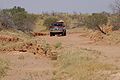
Bore Track (2007)

Bore Track with a View of the Desert (2007)
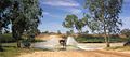
Cooper Creek Crossing in Innamincka , Strzelecki Desert (2007)

Strzelecki Desert (2006)

Rat ( Rattus villosissimus ) in the Strzelecki Desert (2012)
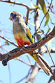
Bluebonnet parrot in the Strzelecki Desert (2012)
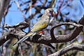
Bluebonnet parrot in the Strzelecki Desert (2012)


Others
Part of the Dingo Fence leads through the Strzelecki Desert .
Web links
- Description of the Desert (English)
- Travel description through the desert (German)
Individual evidence
- ↑ ga.gov.au : Desert , in English, accessed February 27, 2013
- ↑ a b Simpson-Strzelecki Dunefields bioregion ( Memento from June 15, 2012 in the Internet Archive ) (PDF; 1.1 MB): Simpson-Strzelecki dunfields bioregion , in English, accessed on March 4, 2013