
Suhre
| Suhre | ||
 Suhre between Suhr and Oberentfelden |
||
| Data | ||
| Water code | CH : 495 | |
| location | Switzerland | |
| River system | Rhine | |
| Drain over | Aare → Rhine → North Sea | |
| origin | near Oberkirch LU from Lake Sempach 47 ° 9 ′ 44 ″ N , 8 ° 7 ′ 17 ″ E |
|
| Source height | 504 m above sea level M. | |
| muzzle | flows east of Aarau into the Aare Coordinates: 47 ° 24 '22 " N , 8 ° 3' 58" E ; CH1903: 647 363 / 250764 47 ° 24 '22 " N , 8 ° 3' 58" O |
|
| Mouth height | 360 m above sea level M. | |
| Height difference | 144 m | |
| Bottom slope | 4.2 ‰ | |
| length | 34 km | |
| Catchment area | 368.29 km² (2.6 km above the mouth) |
|
| Outflow location: 2.6 km above the mouth |
MQ |
6.45 m³ / s |
| Left tributaries | Uerke | |
| Right tributaries | Ruederche and Wyna | |

| ||
Source and mouth of the Suhre
|
The Suhre (also Sure ) is a 34 km long tributary of the Aare . It flows through the Suhrental in the Swiss cantons of Lucerne and Aargau .
Names
In medieval documents the river had different names: Suron (1036), Suranum flumen (1210), Sure (1241). Since the 20th century, Suhre has been written mostly , and Sure is rare in the canton of Lucerne .
geography
course
The Suhre rises in the Sempachersee in the municipality of Oberkirch (altitude 504 meters) and flows into the Aare east of Aarau at an altitude of 360 meters.
The most important side valley is the Ruedertal , which branches off in a south-easterly direction near Schöftland .
Catchment area
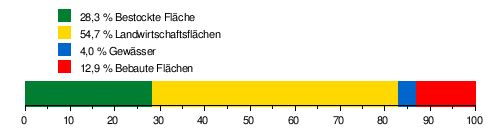
The catchment area of the Suhre is 368.29 km² and consists of 28.3% wooded area , 54.7% agricultural area , 4.0% water surface and 12.9% settlement area .
The mean height of the catchment area is 580 m above sea level. M. , the minimum height is 360 m above sea level. M. and the maximum height at 871 m above sea level. M.
Tributaries
- Hofbach ( left )
- Oberchilerwaldbach ( left )
- Chommlibach ( right )
- Zollbach ( right )
- Dorfbach ( right )
- Schoenebuehlbaechle ( right )
- Erlenstudbaechlein ( right )
- Schlegruetigrabenbach ( Obermoosgrab ) ( right )
- Weiherbach ( Dorfbach ) ( right )
- Engelgrabe ( Ängelgrabe ) ( right )
- Hexenbach ( Häxebächli ) ( right )
- Dorfbach ( left )
- Dorfbach ( right )
- Fischbach ( Dorfbach ) ( left )
- Steinbaerenbach ( right )
- Dorfbach ( left )
- Gründelbach ( Teuffegrabe ) ( right )
- Sägetgrabebach ( left )
- (Bach vom) Rütiberg 4 ( right )
- Dorfbach Attelwil ( Hölibach ) ( left )
- Dorfbach ( right )
- Seeblibächli ( left )
- Eigraben ( left fork )
- Rostbrunnenbächli ( left )
- Dorfbach Kirchleerau ( right )
- Ruederchen ( right )
- Haselbach ( right )
- Talbach ( right )
- Talbach ( right )
- Tannacherbach ( right )
- Uerke ( left )
- Schifflibach ( left )
- Talbächlein ( right )
- Stadtbach Rathaus ( left split )
- Wyna ( right )

Moraines
At the height of Staffelbach , the 30-meter-high terminal moraine from the Würme Ice Age , which was formed when the Reuss Glacier retreated , runs across the Suhrental . Up the valley are the lateral moraines on both sides of the valley on the ridges.
Corrections

The Suhre has been flowing through Sursee as a canalised city stream since the 13th century . The main tributaries are the Wyna and the Uerke .
In 1760 and from 1806 to 1814 the outflow from the Sempachersee was lowered. Up to the 19th century the river in the Suhrental was strongly meandering ; the valley floor was mostly swampy. Since then, several river straightenings have been carried out:
- 1856–59 from Sursee to the canton border
- 1893–98 in Knutwilermoos
- 1923–26 partial correction in the canton of Aargau
- 1943–45 partial correction in the canton of Aargau
- 1945–56 renewed correction in the canton of Lucerne
- 1973-75 in Sursee (with deeper lowering and straightening of the river)
Web links
- Stefan Röllin: Suhre [sura]. In: Historical Lexicon of Switzerland .
- Fish, crabs and mussels in the Suhre catchment area (PDF 798 KB)
- Groundwater-surface water interactions in pre-alpine catchment areas (PDF 2.83 MB)
Individual evidence
- ↑ a b Geoserver of the Swiss Federal Administration ( information )
- ↑ Evaluations of the water network. (XLSX) FOEN , December 2013, accessed on August 9, 2017 (listing of Swiss rivers> 30km).
- ↑ a b c Topographical catchment areas of the Swiss waters: Suhre (2.6 km above the mouth)
- ↑ Height at the mouth
- ↑ Schoenebuehlbaeche, probably wrongly on the geoportal
- ↑ Name after Dorfbachstrasse
- ↑ Right branch from the little thumb
Rivers with a total length of more than 30 km:
Aare |
Albula |
Allaine |
Old Rhine |
Arbogne |
Areuse |
Swiss stone pine |
Birs |
Brenno |
Broye |
Calancasca |
Doubs |
Drance de Bagnes |
Thinning |
Emme |
Engelberger Aa |
Ergolz |
Glâne |
Smooth |
Glenner (Glogn) |
Hinterrhein |
Inn (En) |
Julia (Gelgia) |
Kander |
Little Emme |
Landquart |
Land water |
Langete |
Limmat |
Linth |
Lorze |
Maggia |
Mentue |
Moësa |
Muota |
Murg |
Necker |
Orbe |
Petite Glâne |
Plessur |
Rabiusa |
Reuss |
Rhine |
Rhone |
Saane |
Schüss (Suze) |
Seez |
Scythe |
Sihl |
Simme |
Sitter |
Sorne |
Suhre |
Talent |
Tamina |
Ticino (Ticino) |
Thur |
Töss |
Venoge |
Verzasca |
Vispa |
Vorderrhein |
Wigger |
Wyna