
Sybrita

Sybrita ( Minoan SU-KI-RI-TA ; ancient Greek Σύβριτα ; Σούβριτα ; Σούβριτος ; Σίβυρτος; inhabitant name Σιβρύτιος ), in modern Greek Σύβριτος βριτος Syvritos , an ancient Mediterranean city in the Greek basin of the Greek island of Kreta . It existed from around 1400 BC. Until its destruction during the Arab conquest of the island in 824 AD. Remains of the city complex were found on the 618 meter high Kefala (Κεφάλα) west of Thronos(Θρόνος), a village 19 kilometers southeast of Rethymno .
location
Ancient Sybrita reached its greatest expansion in the Hellenistic period. At that time the urban area reached from today's Klisidi (Κλησίδι) in the northeast to Agia Fotini (Αγία Φωτεινή) in the southwest and Genna (Γέννα) in the south. Klisidi and Agia Fotini are each less than a kilometer away from the city's former acropolis on the hill Kefala ("big head") near Thronos, and Genna about a kilometer.
The city's sphere of influence extended over the entire Amari Basin, a fertile valley irrigated by the small river Platy (Πλατύ) between Rethymno on the north coast of Crete and Agia Galini (Αγία Γαλήνη) on its south coast and Tymbaki (Τυμπάκι) on the western edge of the Messara Level . At Agia Galini there was the port of Sybrita, the ancient Soulia (Σουλία) or Soulena (Σουλήνα). About 5.5 kilometers southwest of the Acropolis, in a cave near Patsos (Πατσός), there is evidence of a sanctuary of Hermes Kranaios , which existed with interruptions from the Late Minoan Period I (SM I) until the Roman period .
The ancient Sybrita is eponymous for today's municipality of Syvritos with the main town Agia Fotini within the municipality ( Dimos ) Amari in the regional district of Rethymno . Until 2010 Syvritos was an independent municipality and comprised the western part of the Amari basin before it was merged with the former municipality of Kourites to the east to form the large municipality of Amari.
history

Sybritas was founded in the late Minoan period, the so-called third or post - palace period . During this period the Mycenaeans ruled Crete. In the Palace of Knossos found inscribed tablets in Linear B , the name of the city with sufficient probability than Su-ki-ri-ta (Sugrita) mentioned what about "City of wild boar / the Boar means". During excavations on 2400 m 2 of the 110 × 80 meter area of the acropolis on the Kefala , the foundation walls of three buildings from the 12th century BC were found in the northwest of the summit. Discovered. To this day, they are the oldest archaeological evidence of settlement in the urban area.
In the following period (1200 to about 650 BC) Sybrita was continuously inhabited. Remnants of buildings from the “ Dark Centuries ” have been preserved on the Kefala , which are assigned to the Geometric Epoch (around 900 to 700 BC). They are to the northeast and south of the summit. A public building erected there was based on the findings of the excavations until the early 7th century BC. Used. Rich surface finds on the southern slopes of the Kefala indicate that the city's residential areas were located here in the following Archaic Epoch (around 700 to 500 BC) up to the Classical Period (around 500 to 336 BC) .

The Hellenistic epoch (336 to 30 BC) meant a time of growth and prosperity for Sybrita. The settlement area expanded to the southwest to today's Agia Fotini, which resulted in emergency excavations there . The construction of the isodomic fortification wall, consisting of hewn ashlar stones of uniform size, of which a narrow part between the Kefala and Keratidi hills has been preserved, is also dated to this period.
Already in the 4th century BC BC coins of the city, staters , were minted. Sybrita was one of the first Cretan cities with its own coins. About 15 of these are known today. The gods Dionysus , Hermes and Zeus are depicted on them. From the city of Gortyn (Γορτύν), allied with Sybrita , between 360 and 330 BC. Chr. Coin motifs of Europa on a plane tree and Zeus in bull shape. Some of the coins contain the word ΣΙΒΡΙΤΙΩΝ (SIBRITION) as an inscription. In terms of foreign policy, alliances with the Ionian city of Teos (201 BC) and in the association of Cretan cities with Eumenes II of Pergamon (182 BC) are handed down in inscriptions .
After the occupation of Crete by Quintus Caecilius Metellus in 69 BC. BC and the incorporation of the island into the Roman Empire , Sybrita flourished due to its location between the Roman island capital Gortyn and Eleutherna (Ἐλευθέρνα) and the north coast at Rhithymna (Ῥίθυμνα). The prominent position of the city is documented by an entry in the Tabula Peutingeriana , a Roman road map from the second half of the 4th century AD. The distance to Eleutherna is given there as 8 miles (VIII milia passuum ), about 12 kilometers. The remains of a large public building have been preserved on the southern plateau of Kefala , the center of Sybrita. A paved ramp led from the south to the building, which dates from the 1st to 3rd centuries AD.

Further architectural remains from Roman times were discovered during emergency excavations in Thronos and Agia Fotini. A Roman burial chamber was found on the northern slope of Kefala , which together with grave inscriptions from Genna in the south point to the boundaries of the urban area with the local cemeteries. The foundation walls and parts of the floor mosaic of an early Christian basilica from the 5th or 6th century have been preserved in Thronos. Sybrita was a bishopric in Byzantine times until the city was destroyed by the Arabs in 824. The much smaller St. Mary's Church (wesentlichαός Παναγίας) of Thronos was built on the ruins of the basilica in the 14th century .
The location of Sybrita southwest of the Psiloritis massif on Kefala near Thronos was identified in 1865 by Thomas Abel Brimage Spratt . Inscriptions, many of which were discovered by Federico Halbherr in 1894 , gave clues about the ancient city. During the occupation of Crete in the Second World War , the German ancient historian Ernst Kirsten carried out the first small excavations at selected sites in 1942 . The British archaeologists Sinclair Hood , Peter Warren and Gerald Cadogan from the British School at Athens uncovered the remains of a settlement from the Postpalace and Geometric Period on Kefala in 1962 .
Since 1986 archaeological excavations have been carried out regularly on the top of the hill under the direction of Luigi Rocchetti and Niki Metaxa Prokopiou , and from 1999 under the direction of Anna Lucia D'Agata . Many of the finds, including vases, figurines, metal objects and some coins, are now in the Archaeological Museum of Rethymno .
- Buildings of ancient Sybrita on Kefala Hill

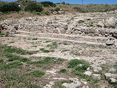
Remains of late Minoan buildings ( SM III C )

Minoan Building 2 (north side of the summit)
Remains of Roman buildings on the Kefala
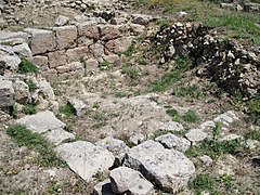
Roman building A2 (south side of the summit)


literature
- Thomas Abel Brimage Spratt: Travels and Researches in Crete . John van Voorst, Paternoster Row., London 1865.
- John Devitt Stringfellow Pendlebury: The Archeology of Crete. An Introduction . Taylor & Francis, London 1939, ISBN 0-416-72590-2 .
- Sinclair Hood, Peter Warren, Gerald Cadogan: Travels in Crete . 1964.
- Niki Metaxa Prokopiou: Sybrita Amariou: First Indications for a New LM III C Site. In: La transizione dal Miceneo all'Alto Arcaismo, dal palazzo alla città. Atti del convegno internazionale, Roma 14-19 March 1988. Rome 1991, pp. 373-401.
- Luigi Rocchetti (Ed.): Sybrita. La valle di Amari from bronzo e ferro. 1, Gruppo editoriale internazionale, Rome 1994.
- Anna Lucia D'Agata: Ritual and rubbish in Dark Age Crete. The settlement of Thronos-Kephala (ancient Sybrita) and the pre-classical roots of a Greek city. In: Aegean archeology. 4, 1997-2000, pp. 45-59.
- Anna Lucia D'Agata: Defining a Pattern of Continuity During the Dark Age in Central-Western Crete: Ceramic Evidence from the Settlement of Thronos / Kephala (Ancient Sybrita) . In: Studi micenei ed egeo-anatolici 41/2 . 1999, p. 181–218 (English, digitized version [PDF; 3.0 MB ; accessed on December 26, 2016]).
- Elisabeth Mlinar: Fortified cities, settlements and other fortification structures in Crete from the Archaic to the end of the Hellenistic period . Dissertation. tape 1 . University of Vienna, Vienna 2014, Thronos, Kephala / Sybrita, p. 64–66 ( digitized version [PDF; accessed on February 26, 2017]).
Individual evidence
- ^ John Younger: Linear A Texts in phonetic transcription & Commentary. 10c. Place Names. people.ku.edu, February 10, 2012, accessed on February 21, 2012 .
- ↑ Pseudo-Skylax p. 18. References for the name forms given by William Smith (Ed.): Dictionary of Greek and Roman Geography . 1854 ( online [accessed June 9, 2010]).
- ^ Claudius Ptolemy 3:17 , 10.
- ↑ Hierocles .
- ^ Polybios in Stephanos of Byzantium sub voce .
- ^ Corpus Inscriptionum Graecarum 2, p. 637.
- ^ A b c Mogens Herman Hansen, Thomas Heine Nielsen: An inventory of archaic and classical poleis . Oxford University Press, Oxford / New York 2004, ISBN 0-19-814099-1 , pp. 1187 ( limited preview in Google Book search).
- ^ David J. Blackman: Soulia or Soulena (Agia Galini), Crete . In: Richard Stillwell et al. a. (Ed.): The Princeton Encyclopedia of Classical Sites. Princeton University Press, Princeton NJ 1976, ISBN 0-691-03542-3 .
- ↑ ΟΙ ΑΡΧΑΙΕΣ ΠΟΛΕΙΣ ΤΗΣ ΚΡΗΤΗΣ (Με αλφαβητική σειρά). www.kairatos.com.gr, accessed June 10, 2010 .
- ^ John Chadwick : The Mycenaean world . Cambridge University Press, Cambridge 1976, ISBN 0-521-21077-1 , pp. 54 ( limited preview in Google Book search).
- ↑ Sebastian Zöller: The society of the early "dark centuries" on Crete. Heidelberg 2005, p. 103 ( uni-heidelberg.de [PDF; 1.4 MB ]).
- ↑ Sybrita or Sybritos (Thronos) Amari district, Crete. www.perseus.tufts.edu, accessed June 28, 2010 .
- ^ Coins from Sybrita, p. 19 (67). (PDF) www.kuenker-muenzen.de, accessed on June 23, 2010 .
- ↑ Klaus Hylla: The Roman Provinces - Gallia Narbonensis, Cilicia, Creta et Cyrena. ( Memento from July 17, 2012 in the Internet Archive ) on: Meinebibliothek.de
- ↑ Tabula Peutingeriana. www.euratlas.net, accessed on June 23, 2010 .
- ^ Johan de Bakker: Across Crete: From Khania to Herakleion . Logos Tekstproducties, Amsterdam 2001, ISBN 90-806150-1-3 , p. 109 ( limited preview in Google Book search).
- ↑ a b c Sybrita Archaeological Project - Thronos Kephala (Storia della ricerca). www.sybrita.org, accessed June 16, 2010 .
- ^ Johan de Bakker: Across Crete: From Khania to Herakleion . Logos Tekstproducties, Amsterdam 2001, ISBN 90-806150-1-3 , p. 125 ( limited preview in Google Book Search).
- ↑ Stella Kalogeraki: Rethymnon - The soul of Crete . Mediterraneo Editions, ISBN 960-8227-15-1 , pp. 56 .
Web links
- Sybrita Archaeological Project - Thronos Kephala, Homepage of the Italian excavation (Italian)
- Thronus Kephala. (PDF) Minoan finds. Heidelberg University, accessed on January 5, 2015 .
- Don Evely: Thronos Kephala. American School of Classical Studies at Athens, February 17, 2011, accessed March 5, 2018 .
- List Cretan coins (english)
- The ancient cities of Crete (English; Greek )
- Sivritos (Ancient) - Thronos village. Interkriti, accessed on January 14, 2017 .
Coordinates: 35 ° 15 ′ 34.5 " N , 24 ° 38 ′ 23.5" E