
Terre-de-Haut
|
Terre-de-Haut Tèdého |
|
|---|---|
.svg)
|

|
| region | Guadeloupe |
| Department | Guadeloupe |
| Arrondissement | Basse-Terre |
| Canton | Trois-Rivières |
| Community association | Grand Sud Caraïbe |
| Coordinates | 15 ° 52 ′ N , 61 ° 35 ′ W |
| height | 0-309 m |
| surface | 6.00 km 2 |
| Residents | 1,532 (January 1, 2017) |
| Population density | 255 inhabitants / km 2 |
| Post Code | 97137 |
| INSEE code | 97131 |
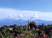
 Looking south over the island from Fort Napoléon |
|
Terre-de-Haut ( Guadeloupe Creole : Tèdého ) is a municipality with 1532 inhabitants (as of January 1, 2017) and an island in the French overseas department of Guadeloupe .
Like its neighboring municipality Terre-de-Bas, it is located on a separate archipelago , the Îles des Saintes or Les Saintes , in the Caribbean Sea , south of the two main islands of Guadeloupe.
The highest point is the mountain peak of the Morne du Chamenau at 309 m. ü. M.
Tourism and fishing are important sources of income .
Among the historical monuments , of which there are several in Terre-de-Haut, are Fort Napoléon des Saintes and Fort Caroline, which have long since served as fortresses, and the botanical garden Jardin exotique du Fort Napoléon .
Web links
Individual evidence
- ^ Description of the botanical garden , excerpt from a book publication by Isabelle Specht, 2007 (French), accessed on December 15, 2013.

Terre-de-Haut, behind: Terre-de-Bas
Îles des Saintes from Basse-Terre ; Terre-de-Haut on the left, Terre-de-Bas on the right
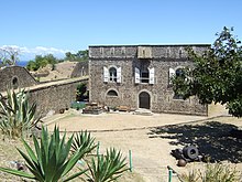
Fort Napoléon des Saintes


