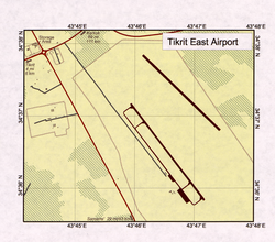
Tikrit East Airport
| East Tikrit Airport | |
|---|---|

|
|
| Characteristics | |
| ICAO code | ORTK |
| Coordinates | |
| Height above MSL | 99 m (325 ft ) |
| Transport links | |
| Distance from the city center | 9 km east of Tikrit |
The Tikrit East Airport ( ICAO : ORTK, FAA : IQ-0052) is a military airport 9 kilometers east of Tikrit ( Iraq ). It is east of the Tigris . Along with Camp Speicher and Tikrit South Airport, it is one of three airports in the vicinity of the city. It has two runways and taxiways and some buildings. He is currently abandoned.
Individual evidence
- ^ Tikrit East Airport. In: SKYbrary. Retrieved March 14, 2015 .