Trojer Almbach
|
Trojer Almbach Trojeralmbach |
||
|
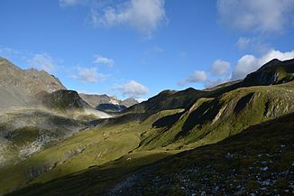
The Sentenboden, headwaters of the Trojer Almbach |
||
| Data | ||
| Water code | AT : 2-374-64-64-30-1 | |
| location | East Tyrol | |
| River system | Danube | |
| Drain over | Schwarzach → Isel → Drau → Danube → Black Sea | |
| source | Sentenboden ( Rosenspitz group ) 46 ° 58 ′ 45 ″ N , 12 ° 15 ′ 18 ″ E |
|
| Source height | approx. 2671 m above sea level A. | |
| muzzle | near St. Jakob in Defereggen in the Schwarzach Coordinates: 46 ° 54 '53 " N , 12 ° 20' 1" E 46 ° 54 '53 " N , 12 ° 20' 1" E |
|
| Mouth height | 1380 m above sea level A. | |
| Height difference | approx. 1291 m | |
| Bottom slope | approx. 11% | |
| length | 11.3 km | |
| Catchment area | 28.9 km² | |
| Left tributaries | Bödensee outflow, Kesselsee outflow, Durfeldbach, Knappenbach | |
| Communities | St. Jakob in Defereggen | |
The Trojer Almbach , also Trojeralmbach , is a brook in the municipality of St. Jakob in Defereggen ( Lienz district ). The Trojer Almbach flows into the Schwarzach near the center of St. Jakob .
course
The source area of the Trojer Almbach is known as Sentenboden. These are the southern slopes between the ridge of the Rosenlenke and the peaks of the Rosenspitze , Reichenbergerspitze and Graue Wand in the Rosenspitz group ( Venediger group ). Starting from the Sentenboden, where the Trojer Almbach is fed by several small source streams, the stream runs in a south-easterly direction through the uninhabited Trojeralm valley. The Trojer Almbach only has named tributaries on the left. In the upper reaches the outflow of the Bödensee flows into the Trojer Almbach, in the area between the Hinteren and Vorderen Trojeralm the drainage of the Kesselsee and the Durfeldbach also flow into. To the south of the Vorderen Trojeralm, the Trojer Almbach curves to the south until it enters the Defereggental north of the center of St. Jakob. It flows through the eastern center of the municipality and finally flows south of St. Jakob into the Schwarzach.
Flood protection and building measures
The Trojer Almbach is a torrent that carries heavy debris. Flood disasters are known from the years 1882, 1957, 1965 and 1991. Potential risk form especially landslides in hillside area of Troja Almbaches that can be poured only to a very limited extent due to the topography. In addition, due to the low gradient, landings and stream outflows can occur in the lower reaches. Due to the very high risk for people and infrastructure, a flood risk management plan was drawn up in 2015, as a result of which torrent and avalanche barriers were started in the same year. The dangers of the creek are to be averted by 2020 primarily through wild wood filters, mud breakers and a bed load metering block. The barrier is 14 meters high and can hold 40,000 cubic meters if necessary. In addition, bed and bank protection measures as well as the rehabilitation of the underflow regulation and the protective forest are to be carried out in the course of the work. The total construction costs of four million euros are shared between the federal government (60 percent), the state of Tyrol (22 percent), the municipality (13 percent) and the state road administration (5 percent).
Energy use
To power the community of St. Jacob 1924 Light St. Jakob cooperative was founded in 1925, a power plant participated in the Troja Almbach in operation. The power plant was soon replaced by a three-phase power plant at the exit of the gorge and supplemented by a plant on the Bruggeralmbach. Since the cooperative could not meet the electricity needs of the tourism companies, the supply area was given to TIWAG in 1975 . The current power plant, whose water catchment was put into operation in 2005, has a gross head of 417 meters and a water volume of 800 liters per second. The expansion capacity is 2700 kW. and the standard work capacity at 12.50 GWh. The water for the power plant is collected below the Vorderen Trojeralm and fed to the power house in the center of St. Jakob by means of a 3.56 km long pressure pipe . Electricity is generated by means of a two-nozzle Pelton turbine .
Individual evidence
- ↑ a b TIRIS
- ↑ Office of the Tyrolean Provincial Government Dept. Environmental Protection (Ed.): Nature Conservation Plan of the Tyrolean River Areas. Classification of the river area-specific natural area potential. District: East Tyrol. Lienz 2004
- ↑ Federal Ministry of Agriculture, Forestry, Environment and Water Management (Ed.): Area directory of the Austrian river basins: Draugebiet. Contributions to the hydrography of Austria, issue No. 59, Vienna 2011, p. 9 ( PDF; 3.5 MB )
- ↑ Federal Ministry of Agriculture, Forestry, Environment and Water Management (Ed.): Flood Risk Management Plan 2015. Risk area: Trojeralmbach - St. Jakob iD 7092. Vienna 2015. ( PDF )
- ↑ mein district.at "Four million for the protection project" Trojeralmbach ", November 19, 2015
- ^ Sprenger engineering office

