Tuen Mun District
| 屯門 區 Tuen Mun District
Tuen Mun |
|
|---|---|
 Location of Tuen Mun within Hong Kong |
|
| Basic data | |
| Country | People's Republic of China |
| Special Administrative Region | Hong Kong |
| surface | 82.9 km² |
| Residents | 489,299 (2016) |
| density | 5903 inhabitants per km² |
| founding | 1982 |
| ISO 3166-2 | HK |
| Website | Tuen Mun District Council (en, zh) |
| politics | |
| Chairman | LEUNG, Kin-man (as of 2019) 梁健文 |
| Political party | DAB ( 民建聯 ) |
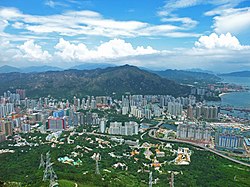
| Tuen Mun Town u. Kau Keng Shan to the east from Castle Peak , 2008 | |
Coordinates: 22 ° 23 '32 " N , 113 ° 58' 12" E
Tuen Mun District ( Chinese 屯門 區 / 屯门 区 , Pinyin Túnmén Qū , Jyutping Tyun 4 mun 4 Keoi 1 ) is the westernmost district of Hong Kong . It is located in the New Territories and the region was called, before it was given its current name in the 1970s, Tsing Shan District ( 青山 區 / 青山 区 , Qīngshān Qū , Jyutping Cing 1 saan 1 Keoi 1 , English Castle Peak District ) the mountain of the same name with the highest local elevation in this area. The Tuen Mun District has been growing rapidly since the planning and development of Hong Kong's satellite cities in the 1960s and 1970s. Today it has one of the highest population densities in the New Territories, alongside districts like Kwai Tsing and Sha Tin . Around 489,299 inhabitants live on an area of 82.89 km². The most important place is Tuen Mun Town ( 屯門 市 / 屯门 市 , Túnmén Shì , Jyutping Tyun 4 mun 4 Si 5 ) next to the new development areas of the New Town , Tuen Mun New Town , with the typical high-rise apartment buildings and shopping centers, in which most of the residents of the Districts live.
geography
Tuen Mun is located south of the Yuen Long Plain ( 元朗 平原 , Yuánlǎng Píngyuán , Jyutping Jyun 4 long 5 Ping 4 jyun 4 ) with Castle Peak ( 青山 , Qīngshān , Jyutping Cing 1 saan 1 - "green mountain"), 583 m above sea level NN , as the highest local elevation in the west. With the other two mountains Yuen Tau Shan ( 圓頭 山 / 圆头 山 , Yuántóu Shān , Jyutping Jyun 4 tau 4 Saan 1 ), 375 m, in the north and Kau Keng Shan ( 九 逕山 / 九 径山 , Jiǔjìng Shān , Jyutping Gau 2 went 3 Saan 1 ), 507 m, in the east they enclose the plan - or satellite town of Tuen Mun New Town and open with Castle Peak Bay ( 青山 灣 / 青山 湾 , Qīngshān Wān , Jyutping Cing 1 saan 1 Waan 1 - "Bay of Castle Peak") in the south to the open sea. A good part of the current buildings in the city center stand on land reclaimed, which formerly belonged to the much larger bay of Castle Peak . The Tuenmun River ( 屯門 河 / 屯门 河 , Túnmén Hé , Jyutping Tyun 4 mun 4 Ho 4 , English Tuen Mun River ), designed on the drawing board, divides the city into an east and west part and serves as an artificial canal for the " Above-ground runoff "of rain or flood in heavy rain and typhoon storms . It has a connection to the original Tuenmun Stream ( 屯門 河溪 / 屯门 河溪 , Túnmén Héxī , Jyutping Tyun 4 mun 4 Ho 4 , English Tuen Mun Stream ) and flows from north to south into Castle Peak Bay. The Tuen Mun District itself also includes the offshore islands of the bay, those from Lung Kwu Chau ( 龍 鼓 洲 / 龙 鼓 洲 , Qīngshān Wān , Jyutping Cing 1 saan 1 Waan 1 , English Lung Kwu Chau - "Dragon Drum Island") and the island pair Mo To Chau ( 磨刀 洲 , Módāo Zhōu , Jyutping Mo 6 dou 1 Zau 1 , English The Brothers (Island) - "whetstone island "), which consists of the two small islands of Großer u. Small Mo To Chau ( 大小 磨刀 洲 , Dà Xiǎo Módāo Zhōu , Jyutping Daai 6 Siu 1 Mo 6 dou 1 Zau 1 - "Big and Small Whetstone Island") consists.
Web links
- Tuen Mun District Information - District Highlights - HK District Councils (Chinese / English)
- Tuen Mun - Hong Kong Fun in 18 Districts - HK Home Affairs Department (Chinese / English)
- Hong Kong Electoral Affairs Commission:
Official Card - Tuen Mun - Wahlkreis- u. District boundaries (Chinese / English) - Lingnan University Hong Kong - Historical image database Tuen Mun (Chinese / English)
- Discover Hong Kong - Tuen Mun (Chinese / German)
Individual evidence
- ↑ a b Citypopulation: [1] on citypopulation.de, accessed on August 25, 2017 - online
- ↑ a b Census and Statistics Department: 2016 Population Census - Key Statistics (PDF file; 396KB) at statistics.gov.hk, accessed on October 25, 2017 - online
- ↑ Politiker-Info 01 (Chinese): [2] , on neodemocrats.hk, accessed on June 1, 2018 - online
- ↑ Politiker-Info 02 (Chinese): [3] , on dab.org.hk, accessed on June 1, 2018 - online
- ^ The Government of the Hong Kong Special Administrative Region - Lands Department: Area by District Council , October 2012, at landsd.gov.hk, accessed April 21, 2013 - Online
- ^ Census and Statistics Department: 2011 Population Census - Fact Sheet for Tuen Mun District Council District , on census2011.gov.hk, accessed April 21, 2013 - Online


