
Unstruttal
| coat of arms | Germany map | |
|---|---|---|

|
Coordinates: 51 ° 16 ' N , 10 ° 27' E |
|
| Basic data | ||
| State : | Thuringia | |
| County : | Unstrut-Hainich district | |
| Height : | 303 m above sea level NHN | |
| Area : | 44.58 km 2 | |
| Residents: | 3100 (Dec. 31, 2019) | |
| Population density : | 70 inhabitants per km 2 | |
| Postcodes : | 99974 (Ammern, Dachrieden, Kaisershagen, Reiser) , 99976 (Eigenrode, Horsmar) |
|
| Area code : | 03601 | |
| License plate : | UH, LSZ, MHL | |
| Community key : | 16 0 64 071 | |
| Community structure: | 6 districts | |
| Address of the municipal administration: |
Herrenstrasse 43 99974 Unstruttal |
|
| Website : | ||
| Mayor : | Michael Hartung (non-party) | |
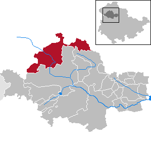
| Location of the municipality of Unstruttal in the Unstrut-Hainich district | ||
  |
||

Unstruttal is a municipality in the Unstrut-Hainich district in Thuringia .
geography
Community structure
The six districts of the municipality are:
Geographical location
The main town of Ammern, with the seat of the municipal administration, and the districts of Reiser, Dachrieden and Horsmar are located on the Unstrut . The locations of Eigenrode and Kaisershagen are on the Muschelkalk plateau leading to the Dün . The lowest point in the municipality is at 210 m above sea level at the Ammern gauge in the south, the highest at 465.6 m above sea level at Eigenröder Warte in the north.
Neighboring communities
In the south and east, Unstruttal borders on the city of Mühlhausen, in the west on the municipality of Anrode and in the north on the municipalities of Dünwald and Menteroda .
Waters
Not far south-west of Ammern is the "Ammern" unstrut water level operated by the Thuringian State Institute for Environment and Geology for the flood watch. The mean flow height of the Unstrut there is 0.75 m, the lowest height was 0.57 m. The highest flood at the gauge established in 1939 was measured on June 4, 1981 at 4.10 m. Southwest of Ammern, the Luhne, the only stream in the municipality, flows into the Unstrut on the right. Otherwise, water-bearing dry valleys rarely provide a significant inflow after the snowmelt , rainy periods or heavy rain events. In particular, these are the Röttelseegraben near Ammern, the Flachstal near Reiser and the Schneidertal near Horsmar. Luhne and Röttelseegraben are dammed with water retention basins.
history
The amalgamation of six municipalities to form the new municipality of Unstruttal was decided by the municipal councils of the old municipalities in March 1995 and signed by the mayors on March 14, 1995. It came into force on September 2, 1995. The first mayor of the community was Rolf-Peter Rommel until 2007.
politics
Municipal council
The council of the municipality of Unstruttal consists of 16 councilors.
The past local elections resulted in the following allocation of seats in the local council:
| Party / list | Seats 2004 | Seats 2009 | Seats 2014 | Seats 2019 |
| Christian Democratic Union (CDU) | 4th | 4th | 4th | 3 |
| Social Democratic Party of Germany (SPD) | 5 | 5 | 5 | 4th |
| Citizens' Initiative Ammern 90 | 5 | 5 | 4th | 5 |
| Free voters | 2 | 1 | 2 | 2 |
| Horsmar District Council | - | 1 | 1 | 2 |
mayor
The full-time mayor has been Michael Hartung since December 1, 2019.
coat of arms
The municipal coat of arms shows a six-leaved golden linden branch at the top and a silver mill iron at the bottom , which is divided green over red by a lowered silver wavy bar.
Economy and Infrastructure
economy
Commercial areas are located in the north of Ammern, southwest of Reiser and at the Dachriedener train station. Horsmar, Kaisershagen and Eigenrode are rural. A large agricultural enterprise is based in the north of Eigenrode.
Infrastructure
Unstruttal is connected to the railway with two regional train stops in Ammern and Dachrieden. A main connection axis in the direction of Göttingen runs through the municipality with the federal highway 247.
Others
The company Wagner & Co. produced in a newly built weapons factory since 1940, machine guns and gun parts with the help of 1,500 forced laborers from several countries.

Web links
Individual evidence
- ^ Population of the municipalities from the Thuringian State Office for Statistics ( help on this ).
- ↑ StBA: Changes in the municipalities of Germany, see 1995
- ↑ 2014 municipal council elections in Thuringia. Thuringian State Office for Statistics, accessed on July 7, 2019 .
- ↑ City council election 2019 in Thuringia. Thuringian State Office for Statistics, accessed on July 7, 2019 .
- ↑ Thuringian Association of the Persecuted of the Nazi Regime - Association of Antifascists and Study Group of German Resistance 1933-1945 (ed.): Heimatgeschichtlicher Wegweiser to places of resistance and persecution 1933-1945, series: Heimatgeschichtliche Wegweiser Volume 8 Thüringen, Erfurt 2003, p. 314 , ISBN 3-88864-343-0
Anrode | Bad Langensalza | Bad Tennstedt | Ballhausen | Blankenburg | Bruchstedt | Dünwald | Greater Vargula | House summer | Autumn life | Hornsummer | Kammerforst | Kirchheilingen | Grains | Kutzleben | Marolterode | Menteroda | Midsummer | Mühlhausen / Thuringia | Nottertal-Heilinger Heights | Oppershausen | Rodeberg | Schönstedt | Südeichsfeld | Sundhausen | Dead life | Unstrut-Hainich | Unstruttal | Primeval life | Bailiwick