
Unterkirnach
| coat of arms | Germany map | |
|---|---|---|

|
Coordinates: 48 ° 5 ' N , 8 ° 22' E |
|
| Basic data | ||
| State : | Baden-Württemberg | |
| Administrative region : | Freiburg | |
| County : | Schwarzwald-Baar district | |
| Height : | 815 m above sea level NHN | |
| Area : | 13.17 km 2 | |
| Residents: | 2582 (December 31, 2018) | |
| Population density : | 196 inhabitants per km 2 | |
| Postal code : | 78089 | |
| Area code : | 07721 | |
| License plate : | VS | |
| Community key : | 08 3 26 065 | |
| LOCODE : | DE UNE | |
| Address of the municipal administration: |
Hauptstrasse 5 78089 Unterkirnach |
|
| Website : | ||
| Mayor : | Andreas Braun | |
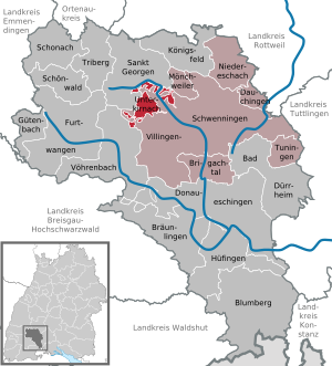
| Location of the community of Unterkirnach in the Schwarzwald-Baar district | ||
  |
||


Unterkirnach is a municipality in Baden-Württemberg and belongs to the Schwarzwald-Baar district .
geography
Geographical location
Unterkirnach is located on the east side of the Black Forest , around seven kilometers from the district town of Villingen-Schwenningen .
Neighboring communities
The community borders in the north on Villingen-Schwenningen and Mönchweiler , in the south on the city of Vöhrenbach and in the north-west on the city of St. Georgen . Unterkirnach shares the postcode with the west of Villingen.
The district of the municipality shows a course that is hardly comparable in Baden-Württemberg. The suburbs of Unterkirnach and Villingen are closely interlinked. While most of the forest areas around the municipality are on the Villingen subdivision, the open areas are on the Unterkirnacher marking. The Villingen-Unterkirnach border alone is approx. 60 km long and forms numerous enclaves and exclaves . The tub in the Stockwald, Groppertal, Hippengehr, Salvest, Viehhof and Neuhäusle are examples of this.
The reason for the distinctive borderline is that Unterkirnach was a dependent, dependent place of the city of Villingen until the beginning of the 19th century. When it was detached from the city, the open areas in Kirnach and Brigachtal were added to the new independent municipality of Unterkirnach, while the forest, one of the largest municipal forests in Baden-Württemberg (around 8,000 hectares) - to this day - near the city of Villingen, now Villingen-Schwenningen remained. The edge of the forest and thus the boundary of the district depicts the local geological conditions, the forest stagnates on the barren red sandstone , while the meadows are laid out in the more fertile granite / gneiss .
Community structure
The municipality of Unterkirnach includes the village of Roggenbach, the Zinken Geisendöbele, Gropper, Grund, Herrenwald, Ippengehr (Hippen-), Moosloch, Schlegeltal , Schlegelwald, Stockwald and Tal, the farms Aspengrund, Bärtleshof, Hinterwasenhof, Leimgruben ,ippenhof, Thomashof and Weiherhaus and the houses Ackerloch, Bärloch, Breitbrunnen, Ellenwinkel, Elleck, Gründle, Hohrain, Im Felsen, "Kirnachtal, Maria Tann Monastery", Neuhäusle, Nollen, Rötenloch, Rossacker, Spechtloch, Wannendobel, Weiherhaus, Winterhalde and Wolfsgrund.
The Kürneck castle ruins are located in the municipality .
politics
Independent municipality in an administrative community
Unterkirnach the congregation is autonomous with its own town hall and mayor's office, heard how the surrounding communities Brigachtal , Dauchingen , Mönchweiler , Niedereschach and Tuningen the Agreed administrative community Villingen-Schwenningen on.
Municipal council
The municipal council consists of the elected voluntary councilors and the mayor as chairman. The mayor is entitled to vote in the municipal council. The local election on May 26, 2019 in Unterkirnach led to the following official final result:
| Party / list | Share of votes | Seats | 2014 result | Result 2009 | |
| CDU / Free Voters | 53.4% | 7th | 54.7% - 7 seats | 51.3% - 6 seats | |
| We in Gütenbach | 43.2% | 5 | 45.3% - 5 seats | 48.7% - 6 seats | |
| FDP | 3.5% | 0 | - | - | |
| voter turnout | 57.4% | 52.9% | 53.7% | ||
mayor
- 1968 to 2002 - Siegfried Baumann
- 2002 to 2013 - Gerold Löffler
- Since December 1, 2013 - Andreas Braun
Braun was elected in October 2013 with 81.73% of the votes in the first ballot.
Attractions
- The Kirnachmühle is a replica of a typical Black Forest mill .
- The wild plant park is intended to bring the natural garden idea closer to the visitor .
- In the children's farm , children can get to know the local farm animals up close.
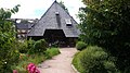
The Kirnachmühle is in the center of the village on the Kirnach between Steinweg and Hauptstraße, the Mühlenplatz is also u. a. used as a marketplace.
The play barn has a common outdoor area with the indoor pool "Aqualino".

The Aqualino is an extension of the Schlossberghalle.

The valley lake lies on the river Kirnachmühle.

The Schlossbergweg leads from the St. Jakobus church to the play barn, playground, Aqualino and the animal barn children's farm


Economy and Infrastructure
traffic
Public transport in Unterkirnach is provided by the Schwarzwald-Baar transport association .
Public facilities
- Outdoor stage
- Play barn - a covered 1,000 m² play and action area for children
- Aqualino indoor swimming pool
- Hiking trails
- Orchestrion exhibition - “the first music automatons ”, together with the German Clock Museum Furtwangen
education
The Roggenbach School is a primary school . All secondary schools are available in the surrounding cities.
societies
- Unterkirnach volunteer fire brigade
- Musikverein Unterkirnach e. V. (oldest association in the community)
- Support association for cultural work and intercommunal contacts Unterkirnach e. V.
- Tennis Club 75 Unterkirnach
- Table tennis club Unterkirnach
- Ksc Unterkirnach
- Ski Club Unterkirnach eV
- FC Alemannia Unterkirnach
- SKC cone friends Unterkirnach
Personalities
Honorary citizen
- Siegfried Baumann, retired mayor D.
- Helmut Glatz, conductor of the Unterkirnach music association from 1981 to 1997
Others
- The first orchestrion was built in 1820 by the music box maker Carl Blessing in Unterkirnach in the Black Forest.
Web links
Individual evidence
- ↑ State Statistical Office Baden-Württemberg - Population by nationality and gender on December 31, 2018 (CSV file) ( help on this ).
- ^ The state of Baden-Württemberg. Official description by district and municipality. Volume VI: Freiburg region Kohlhammer, Stuttgart 1982, ISBN 3-17-007174-2 . Pp. 605-606
- ↑ Local election data 2019 of the State Statistical Office: Unterkirnach , accessed on April 2, 2020

Bad Dürrheim | Blumberg | Bräunlingen | Brigachtal | Dauchingen | Donaueschingen | Furtwangen in the Black Forest | Gütenbach | Hüfingen | Königsfeld in the Black Forest | Mönchweiler | Niedereschach | Schonach in the Black Forest | Schönwald in the Black Forest | St. Georgen in the Black Forest | Triberg in the Black Forest | Tuning | Unterkirnach | Villingen-Schwenningen | Voehrenbach