Verbandsgemeinde Trier-Land
| coat of arms | Germany map | |
|---|---|---|

|
Coordinates: 49 ° 46 ' N , 6 ° 33' E |
|
| Basic data | ||
| State : | Rhineland-Palatinate | |
| County : | Trier-Saarburg | |
| Area : | 175.46 km 2 | |
| Residents: | 21,947 (Dec. 31, 2019) | |
| Population density : | 125 inhabitants per km 2 | |
| License plate : | TR, SAB | |
| Association key : | 07 2 35 5007 | |
| Association structure: | 11 municipalities | |
| Association administration address : |
Gartenfeldstrasse 12 54295 Trier |
|
| Website : | ||
| Mayor : | Michael Holstein ( Free Voters ) | |
| Location of the Trier-Land association in the Trier-Saarburg district | ||


The Trier-Land is a Rhineland-Palatinate municipality in the district of Trier-Saarburg and has its administrative headquarters in the independent city of Trier . The association community includes the eleven independent local communities Aach , Franzenheim , Hockweiler , Igel , Kordel , Langsur , Newel , Ralingen , Trierweiler , Welschbillig and Zemmer , which are located in the vicinity of the city of Trier.
Geographical location
The administrative area of the Verbandsgemeinde extends from the Sauertal (in the west, border with Luxembourg ) to the Kylltal (in the east). To the north it extends to the Fidei (area around Zemmer and the border with the Eifel district Bitburg-Prüm ). In the south it borders on the Moselle and the city of Trier .
The two local parishes of Hockweiler and Franzenheim , which are the only parishes of the "Old Office of Trier-Land" to the right of the Moselle, that were not incorporated into the city of Trier during the 1969/1970 regional reform, also belong to the Trier-Land association. As the “exclave” of the association, they are around ten kilometers from the core area of the association, southeast of the city of Trier.
Association members communities
| Surname | Area (km²) |
Inhabitants (1950) |
Population (December 31, 2019) |
|---|---|---|---|
|
|
6.96 | 479 | 1,086 |
|
|
6.47 | 322 | 369 |
|
|
2.08 | 143 | 279 |
|
|
7.30 | 1.006 | 2,089 |
|
|
16.60 | 1,824 | 2.143 |
|
|
11.93 | 1,467 | 1,735 |
|
|
16.65 | 1,099 | 2,725 |
|
|
27.64 | 1,762 | 2,103 |
|
|
18.42 | 1,257 | 3,747 |
|
|
37.08 | 2,404 | 2,610 |
|
|
24.38 | 2,371 | 3,061 |
|
|
175.49 | 14,134 | 21,947 |
history
In the course of the administrative reform begun in the second half of the 1960s, the previous Trier-Land office , as well as all offices in the administrative districts of Koblenz and Trier , were converted into association communities on October 1, 1968 . The community of Trier-Land in its current form came into being in 1969/1970, when a large part of the communities from the previous offices of Welschbillig and Ehrang were integrated into the Trier-Land community.
Population development
The development of the number of inhabitants in relation to today's area of the Verbandsgemeinde Trier-Land; the values from 1871 to 1987 are based on censuses:
|
|
politics
Association municipal council
The local council Trier-Land consists of 36 honorary council members, who in the local elections on May 26, 2019 in a personalized proportional representation were elected, and the Chairman.
The distribution of seats in the municipal council:
| choice | SPD | CDU | GREEN | FW | FBL | total |
|---|---|---|---|---|---|---|
| 2019 | 7th | 10 | 6th | 13 | - | 36 seats |
| 2014 | 8th | 13 | 4th | 11 | - | 36 seats |
| 2009 | 8th | 14th | 4th | 10 | - | 36 seats |
| 2004 | 8th | 16 | 3 | 4th | 5 | 36 seats |
- FW = Free Voters Trier-Land e. V.
mayor
- 1968–1977 Matthias Winter (CDU, has been mayor of the Trier-Land office since 1954)
- 1978–1987 Hermann Prümm (CDU)
- 1987–1997 Michael Witzel (CDU)
- 1997-2002 Bernhard Kaster (CDU)
- 2003–2019 Wolfgang Reiland (CDU)
- since March 1, 2019: Michael Holstein (Free Voters)
In the runoff election on June 17, 2018, Holstein prevailed with a share of 56.1% of the vote, after none of the original five applicants had achieved a sufficient majority in the direct election on June 3, 2018.
coat of arms
Description : Divided by a twisted blue tip, inside a growing golden column , in front a continuous red cross in silver, behind in silver a red three-pinned castle tower with a blue roof.
Attractions
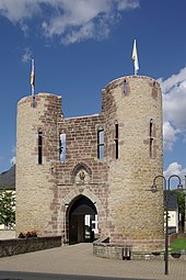
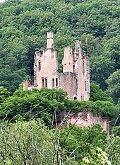
Traces of the Roman past can be seen in the community, for example the Igel Column , which has been part of the UNESCO World Heritage since 1986 , or the Roman long wall . Among the sacred monuments, the Romanesque choir tower church St. Abrunculus from the 12th century in Beßlich and the baroque church St. Remigius in Butzweiler are noteworthy. The Pützlöcher , originally a Roman copper mine, later a quarry for the Cologne Cathedral and others , are one of the oldest preserved mines in Germany. As for castles, Ramstein Castle in the Kylltal and Welschbillig Castle are worth mentioning. You can also find single houses in many places , mostly from the 19th century.
Economy and Transport
In Trierweiler- Sirzenich there is an industrial and commercial area on the federal motorway 64 (Trier-Luxembourg) and on the federal highway 51 (Trier-Bitburg). The area has a size of about one square kilometer.
literature
- Ewald Wegner (arrangement): District of Trier-Saarburg. Verbandsgemeinden Ruwer, Schweich, Trier-Land (= monument topography Federal Republic of Germany , cultural monuments in Rhineland-Palatinate . Volume 12.2 ). Wernersche Verlagsgesellschaft, Worms 1994, ISBN 3-88462-110-6 .
Web links
- Homepage of the Association of Trier-Land
- Link catalog on the topic of the Trier-Land Association at curlie.org (formerly DMOZ )
Individual evidence
- ↑ a b c State Statistical Office Rhineland-Palatinate - population status 2019, districts, municipalities, association communities ( help on this ).
- ↑ a b State Statistical Office Rhineland-Palatinate - regional data
- ^ The regional returning officer RLP: Association council election 2019 Trier-Land. Retrieved August 24, 2019 .
- ^ Trierischer Volksfreund : Michael Holstein becomes mayor. September 24, 2018, accessed December 14, 2019 .
- ↑ Description of the coat of arms


