
Vermes
| Vermes | ||
|---|---|---|
 |
||
| State : |
|
|
| Canton : |
|
|
| District : | Delémont | |
| Municipal municipality : | Val Terbi | |
| Postal code : | 2829 | |
| former BFS no. : | 6726 | |
| Coordinates : | 602.75 thousand / 242158 | |
| Height : | 566 m above sea level M. | |
| Area : | 18.32 km² | |
| Residents: | 308 (December 31, 2012) | |
| Population density : | 17 inhabitants per km² | |
| Website: | www.vermes.ch | |
| map | ||
|
||


Vermes was a municipality in the Delémont district in the canton of Jura in Switzerland . The former German name Pferdmund is no longer used today. On January 1, 2013, it merged with the municipalities of Montsevelier and Vicques to form the new municipality of Val Terbi .
geography

Vermes lies at 566 m above sea level. M. , twelve kilometers east-southeast of the canton capital Delémont (linear distance ). The former street and stream line village extends in a valley widening of the Gabiare , a syncline in the Jura at the north foot of Mont Raimeux that runs parallel to the Delsberg basin .
The area of the municipal area of 18.3 km² includes the Vermes basin, which is bordered to the north by the fold of the Plain Fayen ( 759 m above sea level ) and the Forêt du Droit ( 768 m above sea level ) as well as the Moton ( 797 m above sea level ) m above sea level ) is limited. Between the Moton and the Plain Fayen, the Gabiare has dug the Tiergarten Gorge, a typical Jurassic ridge , into the anticline . The southern part of the municipality includes the northern slope of the Mont-Raimeux chain, on whose ridge with 1241 m above sea level. M. is the highest point of the municipality, as well as the Envelier gorge to the east. In a narrow corner, the soil from Vermes in the east extends to the heights of Schönenberg ( 1193 m above sea level ). The municipal area is drained through the Gabiare to the Scheltenbach (French La Scheulte ), a right tributary of the Birs . In 1997, 3% of the municipal area was accounted for by settlements, 60% by forests and trees and 37% by agriculture.
Vermes includes the hamlet of Envelier (German Im Wiler or Welschwiler ), 624 m above sea level. M. in a valley widening of the Gabiare Klusen at the eastern foot of Mont Raimeux, as well as numerous individual farms. The neighboring communities of Vermes are Rebeuvelier , Vicques , Courchapoix , Corban and Mervelier in the canton of Jura and Schelten , Seehof , Corcelles and Crémines in the canton of Bern .
population
With 308 inhabitants (as of December 31, 2012), Vermes was one of the smaller communities in the canton of Jura. 69.6% of the residents are French-speaking, 28.2% German-speaking and 1.6% English-speaking (as of 2000). The Envelier district traditionally has a high proportion of German-speaking residents ; there are also some traditional Germanic place names (La Wüstmatte, Rambode, Le Schlag, La Rossmatte, Schöne (n) berg, Chez le Zuber, La Sonnenberg, Rière Buchwalder) .
The parish of Vermes had 250 members before the Thirty Years War, afterwards fewer than 60 (in 1660). In 1725 the pastor had 539 members in his parish (note that Vermes then formed a parish with Rebeuvelier). In 1780 the municipality of Vermes counted 603 people without Rebeuvelier.
During the period of French rule in 1804 500 inhabitants were counted in Vermes, in 1838 570 were registered. The population of the village was 605 in 1850 and 452 in 1900. In the course of the 20th century an overall downward trend was registered.
economy
The community is still predominantly agricultural . There are few jobs outside of the agricultural sector in the village. Many employed persons (more than 50%) are therefore commuters and work mainly in the Delémont region.
traffic
The community is far away from the major thoroughfares, with the main access coming from Vicques . There is a bus line on this route that connects Vermes to public transport.
history
Vermes was first mentioned in 769 as a verteme , derived from the Gallic word vertima ( summit , peak ). From the 7th to the 10th century there was a small monastery here that belonged to the Moutier-Grandval Provostry . In 1309 the name Vermunt appears . From 1793 to 1815 Vermes belonged to France and was initially part of the Département du Mont-Terrible , from 1800 connected to the Département Haut-Rhin . By decision of the Congress of Vienna , the place came to the canton of Bern in 1815 and on January 1, 1979 to the newly founded canton of Jura.
At the beginning of 2013, Vermes merged to form the new municipality of Val Terbi.
Attractions
The parish church of Saint-Pierre-et-Paul was built in 1723 using the foundations of a medieval chapel. The church was expanded in several stages at the end of the 18th century. During a restoration in 1962, Gothic wall paintings from the beginning of the 15th century were found. On a ledge on the north slope of Mont Raimeux , 930 m above sea level. M. , is the Raymontpierre Castle (German Remontstein or Remuntstein ), which was built around 1600.
In Envelier there is the Saint-Joseph chapel, the current building dates from 1863, as well as a mill that was in operation until 1970.
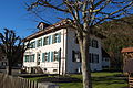
Parish hall

The Gabiare in the center of Vermes

Saint-Pierre-et-Paul church

Interior of the church with the frescoes from the 15th century

Primary school building

gym

Milieu du Village

St-Pierre-et-Paul church

Medieval fresco in the church

Quarry


Web links
- Official website of the municipality of Vermes
- François Kohler: Vermes. In: Historical Lexicon of Switzerland .
Boécourt | Bourrignon | Châtillon | Courchapoix | Courrendlin | Courroux | Courtételle | Delémont | Develier | Ederswiler | Haute-Sorne | Mervelier | Mettembert | Movelier | Pleigne | Rossemaison | Saulcy | Soyhières | Val Terbi
Former municipalities: Bassecourt | Corban | Courfaivre | Glovelier | Montsevelier | Rebeuvelier | Soulce | Undervelier | Vellerat | Vermes | Vicques
Canton of Jura | Districts of the Canton of Jura | Municipalities of the Canton of Jura