
Viðareiði
|
||

|
||
| position | 62 ° 22 ' N , 6 ° 32' W | |
|
Resident rank |
347 (2014) 28 |
|
| Commune | Viðareiðis communa | |
| Post Code | FO 750 | |
| Markatal | 48 | |
|
Grammar dative (in / from ...) genitive (after ...) |
í / úr Viðareiði til Viðareiðis |
|


Viðareiði [ ˈviːjaɹˌaijɪ ] (literally: "wooden isthmus ", Danish name : Viderejde ) is the northernmost place of the Faroe Islands and is located on the island Viðoy , which belongs to the region of the North Islands . Viðareiði is also the name of a Faroese municipality ( Viðareiðis kommuna ), which consists solely of the place Viðareiði.
The place

Viðareiði is stretched out on an isthmus , nestled between high mountains in the north and south.
The place is connected by land via a dam and a tunnel system with the regional center Klaksvík on Borðoy. The road to Viðareiði runs along the west coast of Viðoy, crosses the village and continues on the east coast to the uninhabited Middalur valley . There is a typical small waterfall there. In September 2016, the newly built Viðareiði tunnel was opened, which runs from Middalur across the mountain to the coastal road in the direction of Hvannasund and now offers the opportunity to bypass the rockfall endangered section of the coastal road.
In the north, the mountain Villingadalsfjall rises 844 meters above sea level. It is the highest mountain in the North Islands and the third largest in the entire Faroe Islands archipelago. Towards the north coast it ends with Cape Enniberg , the highest almost vertical cliff in the world (754 m). To the west, Viðareiði offers a view of the mighty northern peaks of Borðoy and Kunoy . In the opposite direction, behind the valley of the isthmus, is the eastern island of Fugloy . In the south rises the 751 meter high cone mountain Malinsfjall , which is also a popular hiking destination. Viðareiði is therefore suitable as a starting point for long mountain hikes . In addition to a small supermarket, there is also the Hotel Norð with its typical local cuisine .
history

The place is mentioned in writing as early as the Middle Ages, for example in 1403 in a document on goods and possessions.
In 1695 the old church was destroyed by a storm. It is said that part of the cemetery was washed away by the sea and that the coffins were then recovered in Hvannasund and buried again in Viðareiði.
The current church dates from 1892. The altarpiece is a copy of the Adoration by Giuseppe Chiari (1654–1727). The silver in the church is a gift from the British government, which has so thanked the people for rescuing the crew of the Marwood brig . The ship had lost its rudder in a winter storm in 1847 en route from Africa to Liverpool and was stranded in the bay east of Viðareiði after a drift of three weeks.
The population of Viðareiði has remained fairly constant over the past ten years. In 2014 the place had 347 residents.
Picture gallery


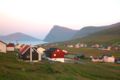
View of Viðareiði from the north

View of Viðareiði from the south
Viðareiði

church

The rectory " í Ónagerði " around 1900.


.JPG)


.JPG)
Personalities
- Andrias Christian Evensen (1874–1917), Faroese politician, textbook author and linguist, born in Viðareiði.
- Christian Matras (1900–1988), Faroese poet and linguist, born in Viðareiði.
- Beginn Kallsberg (* 1947), politician of Fólkaflokkurin and former Prime Minister of the Faroe Islands, born in Viðareiði.
Web links
- Viðareiðis kommuna - the official website of Viðareiði municipality
- Søgan / søgnin um Viðareiði , vidareidi.fo (A little local history in Faroese)
- Faroeislands.dk: Vidareidi , information and photos (English)
Individual evidence
- ^ GVC Young: From the Vikings to the Reformation - A Chronicle of the Faroe Islands Up to 1538 , Shearwater Press, Douglas, Isle of Man 1979
- ↑ fact about Viðareiði , vidareidi.fo
Eiðis | Eystur | Fámjins | Fuglafjarðar | Fugloyar | Hovs | Húsavíkar | Hvalbiar | Hvannasunds | Klaksvíkar | Kunoyar | Kvívíkar | Nes | Porkeris | Runavíkar | Sands | Sjóvar | Skálavíkar | Scopunar | Skúvoyar | Sumbiar | Sunda | Sørvágs | Tórshavnar | Tvøroyrar | Vága | Vágs | Vestmanna | Viðareiðis