
Volcanoes in Iceland

| |||||||||||||||||||
Active volcanic zone and systems in Iceland, as well as the main volcanoes |
In the North Atlantic , the numerous volcanoes of Iceland have created and shaped the main island of the same name as well as a number of smaller islands such as the Westman Islands or the small islands and skerries in the Breiðafjörður fjord . Iceland is one of the few parts of the Mid-Atlantic Ridge that towers above the sea surface.
Geological conditions
There are around 31 active volcanoes in Iceland , with geologists considered to be any volcano that has erupted in the last 10,000 years. However, every volcano has its own rhythm and within it its own phases of more intense and less intense eruption activity, and so there are also volcanoes such as the Grímsvötn or the Hekla , which erupt approximately every four or ten years.
The special density of volcanoes on Iceland is explained by the location on the mid-Atlantic ridge , a rift zone , and by a suspected plume in the mantle below the island, the Iceland plume . The Mid-Atlantic Ridge is mostly an underwater mountain range and consists of two almost parallel mountain ranges with a deep rift in between. It only rises above the sea surface in a few places. One of these places is Iceland. The line of the volcanically active zone follows the course of the Mid-Atlantic Ridge. Magma comes to the surface of the earth through the cracks between the drifting plates, the North American and the Eurasian .
This zone, where most of the island's active volcanoes are located, runs roughly diagonally across Iceland from southwest to northeast: from Reykjanes to Langjökull in the west, from the Westman Islands via Mýrdalsjökull and Vatnajökull to Þeistareykir in the east. In the middle of the country you can see a deviation to the east. The zone of most fissures and tensions lies between these two active mountain ranges and therefore the strongest earthquakes take place there, cf. the one with the epicenter at Selfoss in 2000. A microplate , the Hreppar plate, is suspected here .
Many of the volcanoes that were already active in the Pleistocene were also active in the Holocene . On average, one of the active volcanoes erupts every five years. After the shield of the last ice age melted, very large effusive eruptions seem to have taken place, producing up to 15 km³ of lava. The shield volcanoes such as Skjaldbreiður , Trölladyngja and Ketildyngja are witnesses of this. Later, more explosive eruptions occurred again, such as a major Hekla eruption 2800 years ago , which ejected 3 km³ of tephra . But there were also powerful explosive eruptions before that, for example when Jökulsárgljúfur was formed about 300,000 years ago.
The belt of active volcanoes, and thus the plate boundary, was not always in the same place. A few million years ago the belt did not lie over the Reykjanes Peninsula , but further out in Faxaflói Bay , led from there over the Snæfellsnes peninsula and in an arc to the north to what is now the Húnavatnssýsla district and then north of the country. When the fire of this volcanic belt dried up, the location of volcanic activity shifted to where it is today.
The Snæfellsnes peninsula is an exception to the rule. There, after a pause of several million years, about four million years ago, another phase of activity began, so that one has to speak of a volcanically active zone outside the rift zone . After all, there are three active volcanic systems on Snæfellsnes, of which Snæfellsjökull is the best known.

Cinder cone eruption in the Krafla system (1984)

The Leirhnjúkur crater series is part of the Krafla system in northern Iceland
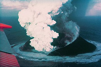
Surtsey : an island is born (1963)

Skjaldbreiður shield volcano

Effusive phase of the Krafla fire eruption series : Lava flows and fountains ( 1984)

Hot spring at the Hengill

The row of craters of Laki craters
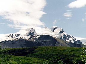
Glaciated stratovolcano Hvannadalshnúkur

Eruption column of the explosive eruption in Eyjafjallajökull (April 2010)
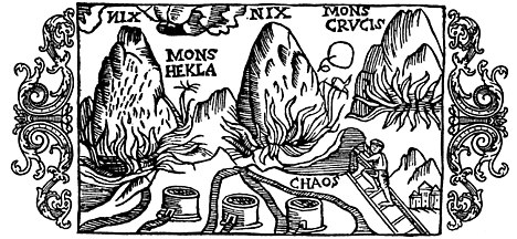
Historic engraving from the 16th century

Hekla and the Souls of the Damned (1585)

View from the Tuffring Hverfjall am Mývatn to various other types of volcanoes: the crater row of Lúdentsborgir , a palagonite ridge and a table volcano ; in the distance on the left you can see another volcanic system: the Dyngjufjöll with the Askja


.jpg)


_Detail_from_map_of_Iceland_1585.jpg)

The main volcanoes

The main volcanoes in Iceland are:
In the south and west of the country: Hekla , Mýrdalsjökull with Katla , Eldgjá and the Laki craters , Hvannadalshnjúkur (or Öræfajökull ), Esja , Snæfellsjökull , Ljósufjöll and Baula .
In the north of the country and in the Icelandic highlands : the glacier Vatnajökull with Bárðarbunga , Grímsvötn and the Kverkfjöll (see also: Glacier Run ) as well as the volcanoes Krafla , Hverfjall , Askja and Herðubreið as well as the Kerlingarfjöll near Hofsjökull . In the southeast there is also Snæfell , the highest mountain and volcano in Iceland outside of Vatnajökull.
There are also some very active volcanoes on the Vestmannaeyjar (Westman Islands) such as B. on Surtsey or the Eldfell on Heimaey . Their system is probably linked to Mýrdalsjökull , as one had to find disappointed during research work on a possible tunnel project between the Westman Islands and the mainland: the seabed there is far too hot for a tunnel.
The area of the Hengill central volcano with Hveragerði and the Haukadalur in southern Iceland with the well-known geysers also belong to the volcanically very active high-temperature areas .
Active volcanic systems and their central volcanoes
"Active" is understood here to mean volcanoes that had their last eruption within the last 10,000 years, and can therefore be considered dormant in some cases (such as Snæfellsjökull ):
See also
- List of volcanoes
- Geography of Iceland
- Geothermal energy in Iceland
- Volcanic system
- List of mountains and elevations in Iceland
Individual evidence
- ↑ cf. z. BHU Schmincke or the American geologist Elisabeth Cotrell from the Smithsonian Institute: "... we call any volcano“ active ”if it has erupted in the last 10,000 years" [1] Accessed May 7, 2010
- ↑ http://www.norvol.hi.is/pdf/wvz.pdf Freysteinn Sigurdsson: Iceland's Western Rift Zone - Field Trip
literature
- Ari Trausti Guðmundsson : Living Earth. Facets of the geology of Iceland . Mál og Menning, Reykjavík 2007, ISBN 978-9979-3-2778-3 .
- Ari Trausti Guðmundsson, Halldór Kjartansson: Land in becoming. An outline of the geology of Iceland . Vaka-Helgafell, Reykjavík 1996, ISBN 9979-2-0347-1 .
- Christof Hug-Fleck: Iceland's natural wonders. 4th completely revised edition, C! H! F Verlag, Au 2010, ISBN 978-3-00-030427-9 .
- Thor Thordarson, Armann Hoskuldsson: Classic Geology in Europe, 3 - Iceland . Terra, Harpenden 2002, ISBN 1-903544-06-8 .
Web links
Photos and videos
General and volcano monitoring
- RG Trønnes, Nordic volcanological Institute, University of Iceland: Geology and geodynamics of Iceland (2070 KB; PDF)
- www3.hi.is: University of Iceland, Jónas Guðnason: Eldvirkni á Íslandi á nútíma ( On volcanism in Iceland ) (Icelandic, 314 kB)
- Smithsonian Inst., Overview map regarding the isl. Volcanoes with links
- Icelandic Meteorological Office: volcano and earthquake monitoring (English)
- Institute of Geosciences, Univ. Iceland (English)
Scientific contributions
- Journal of Geodynamics, Vol. 43, Issue 1, January 2007, P´s 118-152, Hotspot Iceland , T. Thordarson, G. Larsen: Volcanism in Iceland in historical time: Volcano types, eruption styles and eruptive history . doi : 10.1016 / j.jog.2006.09.005 .
- www.raunvis.hi.is: Erik Sturkell, Páll Einarsson e.al: Volcano geodesy and magma dynamics in Iceland (PDF; 4.0 MB)
- For the composition of the rocks (English)
- Sveinn Jakobsson, ea: The Three Igneous Rock Series of Iceland. In: Jökull 58 , 2008 (PDF file; 8.5 MB) (English)
- A. Schöpa: Subglacial Volcanism with examples from Iceland , Institute of Geology, TU Berg-Akademie Freiberg, OS 07-08 (PDF file, English; 2.7 MB)
- H. Tuffen: Models of edifice growth and ice melting at the onset of subglacial basaltic eruptions , Journal of Geophysical Research (2006), Vol. 112, B3203 (PDF; 322 kB)
- R. Andrew, A. Gudmundsson: Distribution, structure, and formation of Holocene lava shields in Iceland, Journal of Volcanology and Geothermal Research, Vol. 168. Iss. 1-4, Nov. 2007, pp. 137-154. doi : 10.1016 / j.jvolgeores.2007.08.011 .
Other
- Country portal with information on volcanism in Iceland
- Blog posts by the Icelandic volcanologist and geochemist Haraldur Sigurðsson (Icelandic)
- Blog posts by the American volcanologist Erik Klemetti, also on Iceland