
Elective field in Wola
.PNG)


From the 16th to the 18th century, the Polish free royal elections took place on the historic electoral field of Wola . Here, at the gates of Warsaw , ten kings were elected, one twice. Today the former village of Wielka Wola is part of the Warsaw district of Wola .
history
As early as 1573, the first Polish royal election - in which the French Heinrich von Valois prevailed - took place on the election field in Kamion, also near Warsaw . The election of the next king ( Stephan Báthory ) in 1576 already took place on the electoral field in Wola. With the exception of another election in Kamion (1734: August III. ), All other Polish electoral kings were decided in Wola.
The last election took place in 1764, when Poland's last king was elected: Stanislaus II August Poniatowski .
- 1574: Anna Jagiellonica
- 1575: Stephan Báthory
- August 19, 1587: Sigismund III. Wasa
- September 27, 1632: Władysław IV. Wasa , no opposing candidates (with 3,543 votes)
- 1648: John II Casimir (with 4,352 votes)
- June 19, 1669: Michael I (Poland) (with 11,271 votes)
- May 21, 1674: Johann III. Sobieski (with 3,450 votes)
- 26./27. June 1697: August II (Poland) (with 13,641 votes)
- July 12, 1704: Stanislaus I. Leszczyński (with 11,697 votes)
- 1733: Stanislaus I. Leszczyński
- September 7, 1764: Stanislaus II August Poniatowski (with 5,320 votes)
Due to the large number of eligible voters present, the election processes were mostly chaotic and subsequently often led to disputes. Nevertheless, the polling place in Wola went down in European history as the most important place of the Polish royal election.
present
Today is located on the former electoral field between the urban development in 1997 by the Society of Friends of Warsaw (Pol. Towarzystwo Przyjaciół Warszawy erected memorial column "Electio viritim") in the Ulica Obowazowa .
Inscription of the column:
“ The Obelisk Electio Viritim was erected on the occasion of the 400th anniversary of Warsaw's appointment as capital on the former electoral field, on which ten Polish kings were elected from 1575 to 1764, in place of the senators' quarters and the knight circle that used to stand here (Polish .: Obelisk Electio Viritim wzniesiony w 400-lecie stołeczności Warszawy na dawnym polu elekcyjnym w miejscu szopy senatorskiej i koła rycerskiego gdzie w latach 1575–1764 obrano 10 królów Polski ) "
In addition, a street running here was named Ulica Elekcyjna (Wahl Street).
Historical representations of various elections
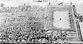
1669: Michał Korybut Wiśniowiecki is elected

1697: election of August II.

1764: Stanisław August Poniatowski is elected


References and comments
- ↑ according to Janusz Durko, album Warszawski / Warsaw album. The image of the city from the collections in the Historical Museum of the Capital City of Warsaw , German-Polish edition, Agencja Reklamowo-Wydawnicza A. Grzegorczyk, ISBN 83-86902-73-6 , Warsaw 2000, p. 99, fig. 68
- ↑ according to Heinhard Steiger, treatises. Legal structures of the European State Order 1648-1792 (PDF; 3.7 MB), extended version of a lecture given by the author on September 17, 1998 at the Italian-German Historical Institute in Trento, Max Planck Institute for Foreign Public Affairs Law and International Law, 1999, p. 629
- ↑ according to Information on the historical plan of the Warsaw Volas up to September 1, 1939 from Sppw1944.org , accessed on January 6, 2012
Web links
literature
- Grzegorz Piątek, Jarosław Trybuś, Warsaw. The thematic guide through Poland's capital , Kamil Markiewicz (Uebers), ISBN 978-3-89728-070-0 , Schröder, Verlag für Regionalkultur, Diepholz 2009, p. 57
Coordinates: 52 ° 14 ′ 37.8 ″ N , 20 ° 58 ′ 3.9 ″ E