
Water
| Water | |
|---|---|
 |
|
| State : |
|
| Canton : |
|
| District : | No district division |
| BFS no. : | 1220 |
| Postal code : |
6484 (Wassen) 6485 (Meien) |
| Coordinates : | 688 747 / 173 391 |
| Height : | 930 m above sea level M. |
| Height range : | 775–3413 m above sea level M. |
| Area : | 96.88 km² |
| Residents: | 398 (December 31, 2018) |
| Population density : | 4 inhabitants per km² |
|
Proportion of foreigners : (residents without citizenship ) |
17.4% (December 31, 2,014) |
| Mayor : | Felix Ziegler (independent) |
| Website: | www.wassen.ch |
 Wassen with the middle Meienreuss bridge |
|
| Location of the municipality | |
  |
|
Wassen is a municipality in the Reuss valley in the canton of Uri in Switzerland .
geography

Wassen is 930 m above sea level. M. above the left bank of the Reuss in the upper part of the Urner Reuss Valley at the entrance to the Meiental and is therefore in the Urner Alps . The Meienreuss flows into the Reuss at Wassen. Below the village is the reservoir at the Pfaffensprung .
The community in the Reuss valley includes the village and some small groups of houses. There are numerous small settlements and groups of houses in Meiental. The largest are Dörfli ( 1280 m above sea level ), Färnigen ( 1459 m above sea level ), Husen ( 1179 m above sea level ) and Kapelle . You are between 3 and 7.5 km from the village on the pass road to the Susten Pass .
Only 26 ha or 0.3% of the municipality is settlement area. More important is the agricultural area with 732 hectares or a share of 7.6%. However, the majority of the municipal area is covered by forest and wood (1726 ha or 17.8%) or unproductive area (water and mountains; 6546 ha or 67%).
Wassen borders in the north on the Obwalden exclave Engelberg , Attinghausen and Erstfeld , in the east on Gurtnellen , in the south on Göschenen and in the west on the Bernese Oberland community of Gadmen .
coat of arms
Note: The municipality of Wassen uses a different drawing than the one shown here with a slightly different representation. Blazon
- In white a red-tongued bear with shouldered yellow round wood
The coat of arms has its origin in the St. Gallus patronage of the Wassner parish church . According to legend, St. Gallus was helped by a bear while building his cell. As early as the 19th century, St. Gall and the bear adorned the parish seal of the church. It is assumed that the coat of arms in its present form originated at the beginning of the 20th century.
population
| Population development | |
|---|---|
| year | Residents |
| 1850 | 1349 |
| 1870 | 1312 |
| 1880 | 2726 |
| 1888 | 935 |
| 1920 | 1111 |
| 1930 | 815 |
| 1941 | 944 |
| 1960 | 879 |
| 1980 | 671 |
| 2000 | 465 |
| 2005 | 466 |
The population of the community (until 1875 Göschenen still belonged to Wassen) remained stable between 1850 and 1870. Due to the construction of the Gotthard tunnel, it reached an all-time record of 2,726 residents in 1880 (together with the outsourced Göschenen 5,718 people; 1870–1880: +336%). After the opening of the Gotthard tunnel, it was higher than before because some of the construction workers stayed in the country (1888: Göschenen and Wassen 1,638 inhabitants, Wassen alone 935). After that, it continued to grow strongly until 1920 (1888–1920: + 19%). In the 1920s there was a huge wave of emigration (1920–1930: −296 people or −27%). There was a brief partial recovery in the 1930s (1930–1941: + 16%). Since then there has been a steady decline in population. Until 1960 it was still limited (1941–1960: −7%). Between 1960 and 2000 the number of inhabitants fell by 414 people to almost half (1960–2000: −47.1%). Since then, the number of residents has remained stable.
languages
The population speaks a highly Alemannic dialect. Almost the entire population speaks German as the everyday language. In the last census in 2000, 94% said German, 2% Serbo-Croatian and 1% Italian as their main language.
Religions - denominations
The population used to be fully members of the Roman Catholic Church. The denominational relationships in 2000 still show this. 409 people were Catholic (88%). In addition, there were 5% Evangelical Reformed Christians, 1% Muslim and 2% non-denominational. 12 people (3%) did not provide any information about their creed.
Origin - nationality
Of the 466 residents at the end of 2005, 434 (93%) were Swiss citizens. The immigrants come from Portugal, Germany, Italy and the former Yugoslavia. At the 2000 census, 433 people (93%) were Swiss citizens; nine of them had dual citizenship.
age structure
The community has a high proportion of older people. While the proportion of people under the age of twenty makes up almost 19% of the local population, a third of the residents are seniors (60 years and older). Because of the lack of work and entertainment opportunities, many young people migrated to the Urner Unterland and stayed there.
The last census in 2000 showed the following age structure:
| Age | 0–6 years | 7-15 years | 16-19 years | 20-29 years | 30–44 years | 45–59 years | 60–79 years | 80 years and more |
| number | 27 | 42 | 19th | 48 | 84 | 90 | 103 | 52 |
| proportion of | 5.81% | 9.03% | 4.09% | 10.32% | 18.06% | 19.35% | 22.15% | 11.18% |
politics
legislative branch
The municipal assembly forms the legislature. It usually meets twice a year.
executive
The five-person council is the executive . He works part-time. The current mayor is Felix Ziegler (as of 2019).
economy
In 2005 there were 18 farms offering 43 jobs. Industry and trade employed 34 people in 7 workplaces, the service sector in 18 companies 121 people (employment converted to full-time positions). The 2000 census showed 20 agricultural and forestry businesses with 50 employees. The 2001 census came to 5 industrial and commercial enterprises with 38 and 24 service companies with 119 employees. Of the 214 employed people in Wassens in 2000, 127 (59%) worked in their own community. Overall, the place offered 198 people jobs, of which 127 (64%) were occupied by locals.
Most of the 87 commuters do their work in other municipalities in the canton of Uri. Including 29 people in Altdorf, 14 in Göschenen, 6 in Silenen and 5 each in Erstfeld and Andermatt. The most important place of work outside the canton was the city of Lucerne .
But there were also 71 commuters. These came mainly from Gurtnellen (14 people), Erstfeld and Göschenen (12 each), Schattdorf (11), Altdorf and Andermatt (5 each).
Attractions
gallery

Photo circa 1889

South entrance to Wassen UR

Center of Wassen

View over Wassen

Cemetery and view down the valley

Motorway access (A2)
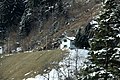
Railway keeper's house near Wassen, Gotthard Railway (2018)
46 ° 42′28.30 ″ N
008 ° 35′45.63 ″ E


.jpg)
traffic


Wassen became world famous through the construction of the Gotthard Railway (1872–1882). The spiral tunnel Muhrentunnel is passed on site. The church , which can be seen from different perspectives several times during the train journey, became the landmark of the route. By means of two spiral tunnels (Wattinger tunnel and Leggistein tunnel) at the village, the track changes direction twice in a double loop with Wassen in the center. This way you pass Wassen and the church three times and just as often cross the Meienreuss, a tributary of the Reuss. The Reuss itself is crossed twice by Wassen upstream in order to reach the Wattinger spiral tunnel on the opposite bank.
The double loop extends the route from the Lower Meienreuss Bridge to the portal of the Naxberg Tunnel (about 2 kilometers as the crow flies) to about 8 kilometers in order to be able to limit the gradient of the railway line in the mountainous terrain to 26 ‰. From the church you have a wonderful panoramic view of the upper Reuss valley.
Trains no longer stop at Wassen station; the place is served in public transport via the bus line Flüelen-Göschenen of the Auto AG Uri, which stops in the town center, every hour.
Wassen is an end point of the main road 11 , which runs through the Meiental over the Susten Pass into the Bernese Oberland and to Vionnaz in Valais , near the border with France. In addition, Hauptstrasse 2 runs through the village, which crosses Switzerland completely in a north-south direction between the borders with Germany (near Basel- Burgfelden) and Italy (near Chiasso ).
literature
- Thomas Brunner: The art monuments of the canton Uri, Volume 4: Upper Reuss Valley and Urseren. Edited by the Society for Swiss Art History GSK. Bern 2008 (Art Monuments of Switzerland Volume 114). ISBN 978-3-906131-89-4 . Pp. 178-236.
Web links
- Website of the municipality of Wassen
- Hans Stadler: Meien. In: Historical Lexicon of Switzerland .
- Hans Stadler: Wassen. In: Historical Lexicon of Switzerland .
Individual evidence
- ↑ Permanent and non-permanent resident population by year, canton, district, municipality, population type and gender (permanent resident population). In: bfs. admin.ch . Federal Statistical Office (FSO), August 31, 2019, accessed on December 22, 2019 .
- ↑ https://www.pxweb.bfs.admin.ch/Selection.aspx?px_language=de&px_db=px-x-0102020000_201&px_tableid=px-x-0102020000_201\px-x-0102020000_201.px&px_type=PX
- ↑ a b Wassen UR municipal coat of arms , accessed on March 11, 2017
- ↑ Thomas Brunner: Wassen and his church. (Swiss Art Guide, No. 808, Series 81). Ed. Society for Swiss Art History GSK. Bern 2007, ISBN 978-3-85782-808-9 .
Altdorf | Andermatt | Attinghausen | Build | Bürglen | Erstfeld | Flüelen | Göschenen | Belt pins | Hospental | Isenthal | Realp | Schattdorf | Seedorf | Seelisberg | Silenen | Sisikon | Spiringen | Undercuts | Water
Canton of Uri | Districts of the canton Uri | Municipalities of the Canton of Uri