
Wehrheim
| coat of arms | Germany map | |
|---|---|---|

|
Coordinates: 50 ° 18 ' N , 8 ° 34' E |
|
| Basic data | ||
| State : | Hesse | |
| Administrative region : | Darmstadt | |
| County : | Hochtaunuskreis | |
| Height : | 312 m above sea level NHN | |
| Area : | 38.36 km 2 | |
| Residents: | 9400 (Dec. 31, 2019) | |
| Population density : | 245 inhabitants per km 2 | |
| Postal code : | 61273 | |
| Area code : | 06081 | |
| License plate : | HG, USI | |
| Community key : | 06 4 34 012 | |
| Community structure: | 4 districts | |
| Address of the municipal administration: |
Dorfborngasse 1 61273 Wehrheim |
|
| Website : | ||
| Mayor : | Gregor Sommer ( CDU ) | |
| Location of the community of Wehrheim in the Hochtaunus district | ||
  |
||

Wehrheim is a municipality in the Hessian Hochtaunuskreis .
geography


Geographical location
Wehrheim is located 305 to 400 meters above sea level in the eastern Hintertaunus on the northern slope of the Taunushauptkamm between Bad Homburg and Usingen . The Limes forms the southern border of the urban area and partly also the district of Wehrheim . In the woods south of the core community is the Lochmühle Schanze , a rampart that could not yet be dated due to a lack of finds.
The community is located in the Rhine-Main area , about 22 kilometers north of Frankfurt am Main and 10 kilometers north of the district town of Bad Homburg vor der Höhe .
Neighboring communities
Wehrheim borders in the north on the city of Usingen and the municipality of Ober-Mörlen ( Wetteraukreis ), in the east on the cities Friedberg (Hessen) and Rosbach vor der Höhe (both Wetteraukreis), in the south on the cities Friedrichsdorf and Bad Homburg vor der Höhe, and in the west to the city of Neu-Anspach .
Community structure
In addition to the core municipality, the municipality of Wehrheim comprises three further districts.
| District | coat of arms | Incorporation | Residents | distance | direction |
|---|---|---|---|---|---|
| Friedrichsthal |
|
December 31, 1971 | 600 | 5.6 km | NO |
| Obernhain |
|
August 1, 1972 | 1,759 | 3.05 km | SW |
| Pfaffenwiesbach |
|
December 31, 1971 | 1,590 | 4.14 km | NO |
With the residential area Saalburgsiedlung / Die Mark, the district of Wehrheim has a spatially separated residential area, which is not, however, a separate district.
For the districts of Wehrheim, Pfaffenwiesbach, Obernhain and Friedrichsthal, local districts with a local advisory board and local council were established by the main statute . The boundaries of the local districts follow the previous district boundaries.
history

The first traces of settlement can be traced back to the Bronze Age . A grave field of the middle to younger urn field culture (10th / 11th century BC) was discovered in Wehrheim. The excavation of this field in 1997 unearthed seven urn graves that could be scientifically evaluated. Wehrheim was first mentioned in a document in 1046. Emperor Heinrich III. bequeathed the "Wirena" property to his wife Agnes in this document. The Burgraves of Friedberg are later named as owners. In the 13th century the imperial property fell to the Counts of Diez . Under the Count of Diez, the town received city rights in 1372, but these were lost again in 1814. In 1243 the Throne Monastery was founded by Count Gerhard von Dietz .
As a successor to the Counts of Diez, Wehrheim came to Nassau-Dillenburg . In the first third of the 16th century, the Counts of Nassau introduced the Reformation . This resulted in conflicts with the neighboring Electorate of Trier . In the Diezer Treaty in 1564, a division of sovereignty over Wehrheim was agreed. The Wehrheim Office thus had both Nassau and Kurtrier authorities.
Wehrheim later became part of Nassau-Usingen , the Duchy of Nassau and, from 1866, Prussian .
In 1895 the railway line from Bad Homburg vor der Höhe, at that time still Homburg, via Friedrichsdorf to Usingen went into operation and was extended a few years later to Weilburg . This tied the community more closely to the Frankfurt area , a development that continued for the next 100 years.
As part of the regional reform in Hesse on December 31, 1971, the municipality of Pfaffenwiesbach and the Friedrichsthal district of the municipality of Kransberg were incorporated into the municipality of Wehrheim on a voluntary basis. On August 1, 1972, the municipality of Obernhain was incorporated by virtue of state law.
Today, Wehrheim, like the other Hochtaunus and Main-Taunus communities, is one of the preferred residential areas for residents with high purchasing power .
politics
Community representation
The local elections on March 6, 2016 produced the following results: compared to previous local elections:
| Parties and constituencies | % 2016 |
Seats 2016 |
% 2011 |
Seats 2011 |
% 2006 |
Seats 2006 |
% 2001 |
Seats 2001 |
||
|---|---|---|---|---|---|---|---|---|---|---|
| CDU | Christian Democratic Union of Germany | 46.2 | 14th | 43.3 | 13 | 51.4 | 16 | 47.2 | 15th | |
| SPD | Social Democratic Party of Germany | 23.9 | 8th | 24.8 | 8th | 26.3 | 8th | 28.3 | 9 | |
| Green | Alliance 90 / The Greens | 16.7 | 5 | 23.3 | 7th | 11.8 | 4th | 11.2 | 3 | |
| FDP | Free Democratic Party | 13.3 | 4th | 6.0 | 2 | 8.5 | 2 | 5.4 | 2 | |
| REP | The Republicans | - | - | 2.7 | 1 | 2.0 | 1 | 2.8 | 1 | |
| GOP-FWG | Community members without party affiliation - Free voter community | - | - | - | - | - | - | 5.1 | 1 | |
| total | 100.0 | 31 | 100.0 | 31 | 100.0 | 31 | 100.0 | 31 | ||
| Voter turnout in% | 61.1 | 56.5 | 54.8 | 63.9 | ||||||


mayor
Gregor Sommer (CDU) has been the town's mayor since 2002.
| mayor | Term of office |
|---|---|
| Johann Peter Jäger | 1849-1882 |
| August Manck | 1882-1900 |
| Peter Eifert | 1900-1908 |
| Heinrich Velte | 1908-1928 |
| Otto Friedrich Manck | 1928-1929 |
| Karl Dillenmuth (SPD) | 1929-1933 |
| Heinrich Wilhelm (NSDAP) | 1933-1945 |
| Ludwig Bender (CDU) | 1946-1959 |
| Richard Wagner (SPD) | 1960-1979 |
| Josef König (CDU) | 1980-1985 |
| Aribert Oehm (SPD) | 1986-1991 |
| Helmut Michel (CDU) | 1992-2002 |
| Gregor Sommer (CDU) | 2002 – today |
coat of arms
The coat of arms is based on seals of the city from the 15th century. It shows the two lions of the Counts of Diez, who ruled the area until 1388, and the first letter of the city. The coat of arms was "forgotten" in the later centuries and in the early 19th century a new seal of the city revealed an unknown building with two towers. The building, a defense structure, was a talking symbol . The current coat of arms was approved in 1953.
Partnerships
-
 Pilisvörösvár , Hungary , partnership since 1984
 -
 Meransen ( South Tyrol ), Italy , friendly contacts since 2001
Economy and Infrastructure
traffic


Despite its idyllic location in the Taunus Wehrheim is yet conveniently located and with six kilometers away junction Friedberg to the National Highway 5 and eight kilometers from junction Oberursel -Nord to the federal highway 661 very well connected to the road network. The federal highway 456 is a bypass road around Wehrheim and leads over the Saalburgpass to Bad Homburg and north over Usingen to Weilburg .
The community has two train stations on the Taunusbahn called RMV - line 15 : the Wehrheim train station and the Saalburg train station (near the Saalburgsiedlung district). The bus route 63 connects the Wehrheim districts with each other and provides a connection to the Taunusbahn at Wehrheim station.
Companies
A well-known product from Wehrheim are the ear plugs from Ohropax GmbH, which are sold under the Ohropax brand . In orthopedics, artificial joints are often anchored with bone cements; the world's best known, Palacos, is manufactured by Heraeus Medical in Wehrheim.
Quartzite plant
In the Köppern valley between Köppern and Wehrheim, but in the Köppern area, CEMEX Kies & Split GmbH, a subsidiary of the global Cemex Group , operates a large quarry in which quartzite has been mined since the end of the 19th century ⊙ (see Köppern # Quartzite movement ).
Educational institutions
The municipality of Wehrheim has a primary school, the Limes School . The old school building was erected in Wehrheim in 1837 and has housed social housing since 1984. At the beginning of the 20th century, a new building was built for the Wehrheim School, which is now used by the Heinrich Kielhorn School. The primary school itself received a modern new building in the 1990s and is now one of the largest primary schools in the district.
Furthermore, the Heinrich Kielhorn School was a special school for learning assistance . Until the regional reform in Hesse , it was named as a special school in the Usingen district. On November 5, 1973, it was named after Heinrich Kielhorn , a pioneer in special education. In 2012 she was relocated to Usingen.

The Taunusheim , founded in 1943 as an orphanage for war orphans, was a children's and youth home for the city of Frankfurt am Main until 1998. Previously, the Hotel Waldfriede, built in 1906, was located in the building . The Hotel Waldfriede had to file for bankruptcy in 1932 and in 1942 it became the property of the city of Frankfurt, which used it as a children's home. In the last 20 years of its existence, the Taunusheim has been the home of up to 18 children and young people between the ages of 6 and 18 who were cared for around the clock in two groups. In 1994 a day care group was added. The home was closed in 1998 due to austerity measures. The educational aid school attached to the Taunusheim remained on the site until 2001, when it was relocated to Frankfurt-Höchst . Demolition work on the home began at the beginning of 2018.
In 1937 the community's first kindergarten was opened in a room in the town hall. It was operated by the NS-Volkswohlfahrt. It had to be closed in the war. On September 15, 1956, a kindergarten was reopened in the old school. December 1973 the kindergarten moved to the current building in Wiesenau. In 1994 the kindergarten in der Lache was added and in 2003 the kindergarten at the temple.
Ammunition depot
In the forest between Wehrheim and Köppern is the Bundeswehr - ammunition dumps "Köppern South". On April 13, 1949, 154 hectares of forest and meadows were confiscated by the US occupation authorities and an ammunition dump was built in the following years. In 1970 there was an intense political debate when the store was to be expanded from 60 ammunition storage bunkers by another 223 bunkers . In particular, the necessary clearing of 67.4 hectares of forest and concerns about the groundwater were criticized by many Wehrheim citizens headed by Mayor Josef König (CDU). Against these concerns, the construction was decided in December 1977 and implemented in 1978/1979. The emerging peace movement took up the criticism and held a number of protests on the edge of the site until the mid-1980s. Rumors about the storage of nuclear weapons also played a role. However, the warehouse was intended and used for the storage of conventional ammunition from the start. After the end of the Cold War , the ammunition depot was taken over by the Bundeswehr in 1997.
Culture and sights
museum

City gate
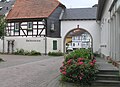
City Gate Museum

Old town scene

Old town scene

Natural monument of an old oak on the road to Pfaffenwiesbach


In the former city gate from 1778 (the so-called Untertor ), a landmark of the place, is the city gate museum Wehrheim, in which the Bronze Age finds of the urn field culture are presented. In 1980 the municipality took over the dilapidated building. Thanks to the cooperation of the history association, the house was renovated and has been used as a museum by the history association since 1983.
Wehrheim "New Center"
.jpg)
While the inner city (or inner village) between the Red City Hall and the city gate has clearly improved in quality thanks to a series of renovated half-timbered houses, the part of the place that is located directly on the former federal highway 456 was hardly worth seeing. For this reason, the municipality acquired the land in question and, by the end of 2011, had built a “new center” with residential and retail properties around a central square.
Buildings
13 kilometers of the Upper German-Raetian Limes , which was declared a World Heritage Site by UNESCO in 2005, run across the municipality . The Kapersburg Roman fort is located near the Pfaffenwiesbach district . To the south, above Wehrheim, on the pass road to Bad Homburg, you can visit the restored Saalburg Roman fort . The “ Red Town Hall ” (the name refers to the red brick, not to the political convictions of the mayors) was built in 1859 next to the Protestant church and is an eye-catcher in the center of the village. In its turret there is a bell that is struck on special occasions. The municipal administration no longer works in the red town hall, but in modern functional buildings in the "new center".

Outside the village is the Kreuzstein. It is a small cross made of Taunus quartzite without an inscription. The stone may have been a boundary stone or an atonement cross in the past . The Kreuzstein used to be at a different location. In 1970 it was restored to its present location by the Wehrheim History and Local History Association. The height was 65 cm.
The Wehrheim cemetery has been the town's municipal cemetery since 1822.
Protestant church

The Protestant church is the larger of the two Wehrheim churches. It was built from 1780 to 1782 as a baroque village church and is located right next to the town hall. The first services in the “new church” took place around Christmas 1781. A church building from the Middle Ages was already on the site of today's church. The marble baptismal font was donated by the then mayor Johannes Groos in 1785 (the tombstone of Johannes Groos is still preserved today and is embedded in the church wall). In 1783, an organ by Johann Conrad Bürgy was installed and inaugurated on July 17, 1783. The organ has a manual and 16 registers with around 880 pipes and is one of only three Bürgy organs that can still be played today; the organ was renovated in 2006. The church has three bells ringing. The oldest was inaugurated in 1638, the youngest in 1951. On October 31, 1817, on the occasion of the celebrations for the 300th anniversary of the Reformation, the "Lutherlinde" was planted "in the alley at the churchyard". In 1958 this was felled to widen the road. The Mainz sculptor Friedrich Drössel carved the crucifixion group in the church from the wood. In 2005 the interior was renovated. The original pastel colors were used again.
Catholic Church

The Catholic Church was built in 1712–1713 on the remnants of the Wehrheim castle complex on behalf of the Archbishop of Trier . The church has been consecrated to the Archangel Michael since 1744 . The choir with neo-Gothic windows and the sacristy were added to the choir between 1899 and 1902 under Pastor Wilhelm Gotthardt. In 1955 the church was renovated and redesigned again under Pastor Ernst Paul Roos. The neo-baroque altar structures of the high and St. Mary's altars, the pulpit and the 14 stations of the cross from Nauort in the Westerwald were transferred to the Wehrheim church.
In the years 1970–1973 the church was rebuilt again in accordance with the liturgical reorganization of the Second Vatican Council . The pulpit, high altar and communion bench were removed. In 1993 the interior of the church was renovated again.
The oldest part of the interior is the cross from 1694 hanging over the altar. Next to the altar is the marble baptismal font from 1729.
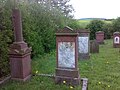
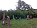
Jewish Cemetery
The Jewish cemetery in Wehrheim was the burial place for members of the Jewish religious community in Anspach and Wehrheim between 1864 and 1938. This Jewish community was wiped out during the Nazi era . The cemetery is about two kilometers outside of Wehrheim in the Bizzenbachtal near the Ludwig Bender Bad. About a dozen gravestones have been preserved and serve to remember the history of the Jews in Wehrheim and the National Socialist terror.
Jewish Cemetery
Jewish Cemetery


Leisure and sports facilities
The Lochmühle is a well-known amusement park directly at the Saalburg train station of the Taunusbahn . The (few) remains of the small fort Lochmühle are also on the site .
Outside the district of Wehrheim, in the direction of Usingen, the Oberloh sports facility is located on the edge of the forest . A lawn sports field, hard court, running track and athletics facilities are available to athletes as well as a clubhouse and a playground. Part of the facility is the Oberloh shooting sports center , which has shooting ranges (50 m and 25 m) for air rifles, small-caliber rifles and sport pistols. TSG Wehrheim, which uses the square, was founded in 1861.
In the Obernhain district, next to the Saalburg settlement, the most expensive Wehrheim location, there is the tennis club and the Saalburg hall.
The sports facility on Kransberger Strasse in the Pfaffenwiesbach district has been offering two artificial turf sports fields since August 2017, one of which is a large and a small field for junior teams, a street basketball facility and an inline skating facility. There is also a clubhouse here.
The Ludwig-Bender-Bad (named after the former mayor, during whose time in office it was built) in the Bizzenbachtal is the open-air swimming pool of the municipality of Wehrheim. It was excavated by the US Army in 1956 (in return for dismantling road material for the ammunition depot). Since then it has been expanded several times and equipped with solar heating.

Ludwig-Bender-Bad: main basin

Ludwig-Bender-Bad: children's pool

Ludwig-Bender-Bad: changing rooms and catering


Personalities
Born in Wehrheim
- Johann Leicker (1772–1844), landowner and member of the Nassau state parliament
- Johann Adam Allendörfer (1778–1848), high school student from Wehrheim and member of the 2nd Chamber of the Estates of the Duchy of Nassau
- Heinrich Velte (1782–1861), farmer and member of the Nassau state parliament
- Carl Helmrich (1790–1834), Hanoverian captain in the Wars of Liberation and member of the estates of the Grand Duchy of Hesse
- Peter Jäger (1807–1882), mayor and member of the Nassau state parliament
- Adam Emmerich (1808–1869), Nassau judge and member of the state parliament
- Heinrich Friedrich Velte , post keeper and community leader in Wehrheim
- Hermann Scheer (1944-2010), politician and recipient of the Alternative Nobel Prize ( Right Livelihood Award )
- Jürgen von Gartzen (* 1958), racing driver
Associated with Wehrheim
- Ludwig Eisenberger (1541–1591), bailiff in Wehrheim
- Johann Conrad Bürgy (1721–1792), Swiss-German organ builder, built the organ of the Evangelical Church in 1783
- Heinrich Kielhorn (1847–1934), pioneer of special education; The Heinrich Kielhorn School is named after him
- Dietrich Ratzke (* 1939), journalist
- Almut Gwiasda (* 1945), former member of the state parliament
literature
- Johanna Koppenhöfer: Wehrheim-Wirena - The Chronicle. 2009, ISBN 978-3-00-028403-8
- Johanna Koppenhöfer: Wehrheim, a fortified place. In: Ingrid Berg (Ed.): Heimat Hochtaunus. Frankfurt am Main 1988, ISBN 3-7829-0375-7 , pages 161-163
- Literature about Wehrheim in the Hessian Bibliography
- Literature on Wehrheim in the catalog of the German National Library
Web links
- Internet presence of the community of Wehrheim
- Wehrheim, Hochtaunuskreis. Historical local dictionary for Hessen. (As of December 18, 2015). In: Landesgeschichtliches Informationssystem Hessen (LAGIS).
- 360-degree views of Wehrheim
- Link catalog on Wehrheim at curlie.org (formerly DMOZ )
Individual evidence
- ↑ Hessian State Statistical Office: Population status on December 31, 2019 (districts and urban districts as well as municipalities, population figures based on the 2011 census) ( help ).
- ↑ Eckhard Laufer: Wehrheim: the gateway to the Bronze Age in Usinger Land . In: “Yearbook Hochtaunuskreis”, 1999, ISSN 0943-2108 , pages 167–175.
- ^ Federal Statistical Office (ed.): Historical municipality directory for the Federal Republic of Germany. Name, border and key number changes in municipalities, counties and administrative districts from May 27, 1970 to December 31, 1982 . W. Kohlhammer GmbH, Stuttgart and Mainz 1983, ISBN 3-17-003263-1 , p. 379 .
- ↑ Law on the reorganization of the Obertaunus district and the district of Usingen (GVBl. II 330-18) of July 11, 1972 . In: The Hessian Minister of the Interior (ed.): Law and Ordinance Gazette for the State of Hesse . 1972 No. 17 , p. 227 , § 3 ( online at the information system of the Hessian state parliament [PDF; 1,2 MB ]).
- ↑ Gerstenmeier, K.-H. (1977): Hessen. Municipalities and counties after the regional reform. A documentation. Melsungen. P. 275
- ^ Result of the municipal election on March 6, 2016. Hessian State Statistical Office, accessed in April 2016 .
- ^ Hessian State Statistical Office: Result of the municipal elections on March 27, 2011
- ^ Hessian State Statistical Office: Result of the municipal elections on March 26, 2006
- ^ Wehrheim - Wehrheim coat of arms (coat of arms). In: www.ngw.nl. Retrieved October 28, 2016 .
- ↑ Angelika Baeumerth: Chronicle 1972-2000 Hochtaunuskreis, 2001, page 11
- ↑ Once in the hands of the US Army, today the Bundeswehr area, in Taunus Zeitung from June 25, 2008
- ^ Johanna Koppenhöfer: Wehrheim-Wirena , page 394-395
- ↑ Sühnekreuz.de; Search for Kreuzstein via "Hessen" and "Hochtaunuskreis"
- ^ Heinrich Riebeling: Stone crosses and cross stones in Hessen. Noltemeyer, Dossenheim / Heidelberg 1977, ISBN 3-88172-005-7 , p. 147, item 5617.1
- ^ Church leader Hochtaunus. P. 72/73 (online ( memento of September 24, 2015 in the Internet Archive ) [PDF; 4.8 MB]). Retrieved January 14, 2016.
- ^ Church leader Hochtaunus. P. 74/75 (online ( memento of September 24, 2015 in the Internet Archive ) [PDF; 4.8 MB]). Retrieved January 14, 2016.
