Weilrode
|
Weilrode
Rural community of Sonnenstein
Coordinates: 51 ° 34 ′ 13 ″ N , 10 ° 27 ′ 43 ″ E
|
|
|---|---|
| Height : | 260 m above sea level NN |
| Postal code : | 37345 |
| Area code : | 036072 |
|
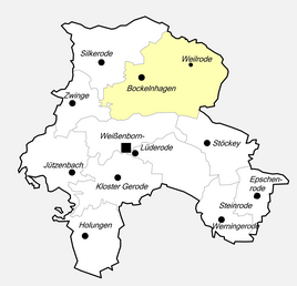
Location of Weilrode in Sonnenstein
|
|
Weilrode is a district of the rural community of Sonnenstein in the Eichsfeld district in Thuringia and one of the few villages in the Eichsfeld district that is not part of the historic Eichsfeld .
location
Weilrode is located in the extreme northeast of the Eichsfeld district, right on the state border with Lower Saxony . The village is connected to neighboring Bockelnhagen via Kreisstraße 205 . Weilrode is located in the narrow valley of the Weilroder Eller in the wooded landscape of the Silkeroder hill country , which is already part of the southern Harz. To the south of the village are the sources of the helmets , to the east those of the Sete . To the north are Bad Lauterberg and the Harz Mountains and to the southwest is the Eichsfeld.
history
The village was first mentioned in a document on September 21, 1209. Due to the border security measures of the GDR , numerous farms were abandoned and demolished between 1952 and 1989 due to emigration and forced resettlement.
Web links
Individual evidence
- ^ Wolfgang Kahl : First mention of Thuringian towns and villages. A manual. Rockstuhl Verlag, Bad Langensalza, 2010, ISBN 978-3-86777-202-0 , p. 306
- ↑ Volker Große, Gunter Römer: Lost cultural sites in Eichsfeld 1945 to 1989 A documentation . Eichsfeld Verlag, Heilbad Heiligenstadt, 2006, page 212
