
Wiesenbach (Baden)
| coat of arms | Germany map | |
|---|---|---|

|
Coordinates: 49 ° 22 ' N , 8 ° 48' E |
|
| Basic data | ||
| State : | Baden-Württemberg | |
| Administrative region : | Karlsruhe | |
| County : | Rhein-Neckar district | |
| Height : | 138 m above sea level NHN | |
| Area : | 11.13 km 2 | |
| Residents: | 3119 (December 31, 2018) | |
| Population density : | 280 inhabitants per km 2 | |
| Postal code : | 69257 | |
| Area code : | 06223 | |
| License plate : | HD | |
| Community key : | 08 2 26 097 | |
| Address of the municipal administration: |
Hauptstrasse 26 69257 Wiesenbach |
|
| Website : | ||
| Mayor : | Eric Grabenbauer | |
| Location of the municipality of Wiesenbach in the Rhein-Neckar district | ||
  |
||

Wiesenbach is a municipality in the Rhein-Neckar district in Baden-Württemberg .
geography
Geographical location
The place is located on the L 532 / B 45 , scenic between the heights of the Odenwald and the Kraichgau hills at 127 to 327 meters above sea level, 15 km east of Heidelberg . The Biddersbach flows through the village . It is also called the gateway from the Kleiner Odenwald to the Kraichgau .
Neighboring communities
The community borders on the city of Neckargemünd in the north, Lobbach in the east, Mauer in the south and Bammental in the west .
Community structure
The Langenzell castle and homestead belong to the municipality of Wiesenbach .
history
Wiesenbach
Foundation of the place and first mention
Wiesenbach was probably one of the original landmarks of the place Reilsheim , which was absorbed into today's Bammental municipality, and was probably founded from there as an extension. The town could have been founded around 700, and an early medieval tombstone fragment found in 1964 indicates an aristocratic court that already existed in the 9th century. However, Wiesenbach was first mentioned in a document in the first half of the 12th century.
Wiesenbach as a possible seat of the Counts of Lauffen
According to older literature, the Kühburg, which is now lost , was built by the Counts of Lauffen . They are said to have controlled the long-distance connection from Heidelberg via Mosbach to Würzburg from there around 1100 as feudal people of the Worms bishop and count of Kraichgau and Elsenzgau . The Lauffeners moved their headquarters to the nearby Dilsberg Castle above the Neckar as early as 1140 , the importance of which as a waterway began to surpass that of the old Fernweg. More recent publications contradict this thesis and rather date the system to the Roman period.
Provost office of the Ellwangen monastery
The Lauffeners left their property in Wiesenbach, including the Wiesenbach Monastery they founded , which was subordinate to the Ellwangen Monastery . After the Lauffeners left, the castle was probably used as a quarry to expand the Wiesenbach monastery, where relics of Saints Benignus and Mammes were kept. The Ellwangen monastery, which had lost numerous possessions on Bergstrasse in the early 12th century , also acquired property and sovereignty rights in Langenzell, Dilsberg , Neckargemünd with Kleingemünd , Bammental and Reilsheim , Mauer and Meckesheim , Zuzenhausen and Eschelbronn through the acquisition of the Wiesenbach aristocratic estate , Mönchzell and Spechbach as well as Lobenfeld and Waldwimmersbach . The provost's office of the Ellwang property was therefore relocated on Bergstrasse from Schriesheim to Wiesenbach, which in future would become an administrative center in Ellwang.
Abolition of the monastery
Together with Dilsberg, Wiesenbach became part of the Electoral Palatinate at the beginning of the 14th century . The Ellwang monastery property came to the Schönau monastery in the second half of the 15th century and, after the abolition of the monasteries in the course of the Reformation around 1560, also to the Electoral Palatinate. The former Wiesbacher Provost property was removed shortly after the dissolution of the monasteries from the other Schönauer possession and the possession of the former monastery Lobenfeld to Schaffnei Lobenfeld combined, which was managed from the future. The former monastery estates were given on a long lease , whereby the property was quickly parceled out by dividing the inheritance , while the attached Fronhöfe were assigned as temporal holdings until the late 18th century and only then divided into 20 lots to promote agricultural development. Most of the former provost property also came into private ownership in the 19th century, primarily through replacement agreements. The Palatinate Katholische Kirchenschaffnei , which has managed the former goods of the Schaffnei Lobenfeld since the early 19th century, today essentially only has forest ownership in Wiesenbach. Nothing has been preserved from the former Propsteihof, which stretched in the center of Wiesenbach, roughly in the area of today's main street between the Catholic and Protestant churches.
From the Electoral Palatinate to the Rhein-Neckar district
When the Electoral Palatinate was dissolved in 1803, Wiesenbach fell to Baden . The district administration was moved from Dilsberg to Neckargemünd, so that Wiesenbach was initially part of the Neckargemünd district office before it was moved to Eberbach in 1857. In 1864 the district office of Eberbach was replaced by the district office of Heidelberg, which in 1939 became the district of Heidelberg and in 1973 was merged into the Rhein-Neckar district , to which Wiesenbach belongs today.
Formation of today's townscape
The core of the settlement of Wiesenbach is located in the upper village near the Schloßberg spring south of the Kühburg castle stables , in the area of today's main street roughly between the Protestant and Catholic churches. Roman settlement has already been proven at this point, later the Carolingian aristocratic court was built there, followed by the Ellwangian provost with St. Georg's monastery church (forerunner of the Catholic church of St. Michael ), parish church of St. Giles (today's Protestant church) and Schultheißenhof. To the east of it were the homesteads. The old trunk road from Heidelberg to Mosbach ran south of the town center, which is why some old buildings such as the half-timbered house Hauptstrasse 68 from 1620 have their entrance facing away from the main road to the south. The construction of today's main street was only possible after the old cemetery near the Protestant church was closed in the 19th century.
A few hundred meters north-west of the upper village, the lower village developed along the Geleitstrasse to Heidelberg (in the area of today's Poststrasse) as a settlement of farmsteads following a medieval mill. The Rose and Krone inns as well as the guardhouse, slaughterhouse and forester's house were also built there. In 1817, when the post office was relocated from Mauer to Wiesenbach, the Badischer Hof building complex was added.
Oberdorf and Unterdorf remained very small until recently. In 1749 21 residential buildings were counted in the upper village and 13 residential buildings in the lower village. It was not until 1900 that the two settlement centers, which at that time contained around 100 residential buildings, grew together to form a coherent townscape. As the new center of the village, the school and town hall were built between the settlement centers in 1901/02, and in 1928/29 the Deywiesen, also located between the centers, was opened up. After that, the place grew strongly, mainly due to the industrial area in the southwest and new development areas in the northwest and southeast. In 1970 there were already over 300 residential buildings in the area, and since then the number of residents has roughly doubled again.
Langenzell
The village of Langenzell, mentioned for the first time around 1300, was manorial and ecclesiastically closely linked to Wiesenbach, but developed political independence as early as the high Middle Ages. As a result of the Thirty Years War , the village was devastated and abandoned. Under the von Wrede family, a manor with a manor house was built on the site of the former village in the late 18th century. In 1803 Langenzell came to Baden like Wiesenbach. In 1925 Langenzell was incorporated into Wiesenbach. Today the place consists essentially only of the manor and the New Palace, completed in 1883, as well as a few surrounding houses.
Population development
The population development of Wiesenbach essentially corresponds to that of the entire northern Kraichgau. Strong growth can be noted for the first time in the 18th century, around 1850 poverty led to emigration and emigration, after which, interrupted by individual crises, there was slow growth until the Second World War. The growth in the post-war period is due to displaced persons who had settled in the post-war years and to the designation of large building areas and the settlement of commuters.
|
|
|
politics

Municipal council
The Wiesenbach municipal council has 12 elected members, plus the mayor with voting rights as chairman.
The 2019 local elections led to the following result (in brackets: difference to 2014):
| City council election 2019 | |||||
| Political party | percent | Seats | |||
| Green | 35.5 (+7.3) | 4 (+1) | |||
| Free voters | 23.6 (−1.9) | 3 (± 0) | |||
| CDU | 21.0 (−2.5) | 3 (± 0) | |||
| SPD | 19.9 (−2.9) | 2 (−1) | |||
The turnout was 71.7% (+7.6).
mayor
The mayor is directly elected every eight years. Eric Grabenbauer has been in office since 2003.
coat of arms
The blazon of the coat of arms reads: In green a lowered silver wavy bar, floating above the black Latin capital letter W.
The coat of arms goes back to a court seal from 1752, at that time still with the letters "WB". Wiesenbach accepted it in 1900 at the suggestion of the General State Archives.
The flag is white and green and was awarded by the Ministry of the Interior in 1970.
Town twinning
Wiesenbach maintains partnership relationships with:
Culture and sights

Buildings
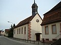
The Evangelical Church was first mentioned in 1370 and was once consecrated to Saint Giles. The oldest part of the church is the choir area in the tower base built around 1200, the church building was renewed around 1750 and expanded to its present form in 1846.
The Catholic Church of St. Michael opposite the Protestant Church was built around 1740 on the foundation walls of the former monastery church of St. George from the 12th century. A structural remnant of the monastery church is the gravel-filled crypt under the choir. Like the neighboring rectory, the old main nave, which stands along the main street, essentially dates from the Baroque period and was expanded in 1977/81 to include a larger side extension and a parish hall.

The town hall square forms a remarkable ensemble with the village linden tree, the fountain and the town hall, which also served as a school house in the past. The town hall, which is considered the town's landmark, was built in 1901/02 as the new center between Oberdorf and Unterdorf . The local history museum is located in the attic of the town hall.
The former brickworks in Poststrasse was converted into a community gallery.
In the Herrenwald to the north of the village there are ruins of the Villa Rustica , a Roman estate . It also includes a Roman wooden fountain that was restored after excavations in the 20th century.
The New Castle in Langenzell with an English landscape garden was completed in 1883. It is privately owned and cannot be viewed. An artists' village has been established in Langenzell since 1990. Nine artists and artisans currently live and work here. Some of them have an international reputation. Particularly worth seeing: the Langenzell art room, which is housed in the former distillery.
Catholic Church of St. Michael
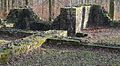
Part of the main building of Villa Rustica


theatre
The theater group “Lambefiewa” regularly develops new pieces that are premiered in the Biddersbachhalle.
Museums
There is a local history museum in the town hall. The former brickworks on Poststrasse became a community gallery in 2008 and shows art and handicrafts by local artists in changing exhibitions.
Natural monuments
Parts of the district are located on the area of the prehistoric Neckar loop that flowed around the "Hollmuth" part of the Kleiner Odenwald . The place is framed by numerous orchards. There are 24a designated biotopes in the Langenzell district.
Sports
- since 1980: Reiterverein Wiesenbach eV, annual rider festival on Ascension Day with catering.
- since 1905: SG 05 Wiesenbach
- since 1975: Gymnastics Club Germania
- since 1979: Wiesenbach tennis club
The Wiesenbach Carnival Association WCS “Die Schisselhocker” and TV Germania Wiesenbach take care of the dance sport.
Regular events
- "Wissebacher Kerwe" - organized by the Wiesenbacher Kerweborscht
- “Most and Wine Festival” with a craft market - organized by the cultural community with the Biedermeier group
- “Music festival with rock night” - organized by the Wiesenbacher Musikverein
Economy and Infrastructure
education
The Panorama Primary School is located in Wiesenbach.
Youth work
- There is a youth club in Wiesenbach.
- The volunteer fire brigade and the Wiesenbach music club offer a youth department.
Personalities
Persons connected with Wiesenbach
- Géza Alföldy (1935–2011), Hungarian-born German ancient historian specializing in Roman inscriptions and social history
Individual evidence
- ↑ State Statistical Office Baden-Württemberg - Population by nationality and gender on December 31, 2018 (CSV file) ( help on this ).
- ^ The state of Baden-Württemberg. Official description by district and municipality. Volume V: Karlsruhe District Kohlhammer, Stuttgart 1976, ISBN 3-17-002542-2 . Pp. 385-386
- ↑ Wüst 1970, p. 65.
- ↑ Wüst 1970, pp. 68/69.
- ^ Nicolai Knauer: The castles of the counts of Lauffen in the Neckar valley . In: Christhard Schrenk, Peter Wanner (eds.): Heilbronnica 5 . Contributions to the city and regional history. Heilbronn City Archives, Heilbronn 2013, p. 102 f . ( PDF; 2.9 MB [accessed on February 21, 2014]).
- ↑ Wüst 1970, pp. 70/71.
- ↑ Wüst 1970, pp. 85-90.
- ↑ Wüst 1970, pp. 90-92.
- ↑ without Langenzell
- ↑ with Langenzell
- ↑ with Langenzell
- ^ State Statistical Office of Baden-Württemberg: Municipal council elections 2019, Wiesenbach ; Wiesenbach municipality: municipal council election 2019 (PDF) ; accessed May 31, 2019.
literature
- Günther Wüst: On the history of Wiesenbach and Langenzell , Wiesenbach 1970
Web links

Altlußheim | Angelbachtal | Bammental | Brühl | Dielheim | Dossenheim | Eberbach | Edingen-Neckarhausen | Epfenbach | Eppelheim | Eschelbronn | Gaiberg | Heddesbach | Heddesheim | Heiligkreuzsteinach | Helmstadt-Bargen | Hemsbach | Hirschberg an der Bergstrasse | Hockenheim | Ilvesheim | Ketch | Ladenburg | Laudenbach | Gluing | Lobbach | Malsch | Wall | Meckesheim | Mulhouse | Neckarbischofsheim | Neckargemünd | Neidenstein | Neulußheim | Nut hole | Oftersheim | Plankstadt | Rauenberg | Reichartshausen | Reilingen | Sandhausen | Schönau | Schönbrunn | Schriesheim | Schwetzingen | Sinsheim | Spechbach | St. Leon-Rot | Waibstadt | Walldorf | Weinheim | Wiesenbach | Wiesloch | Wilhelmsfeld | Zuzenhausen