Zemun
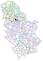
| Location in Belgrade | Situation in Serbia |
|---|---|

|

|
| Basic data | |
| State : | Serbia |
| surface | 15,356 ha |
| Residents | 152,950 |
| Postcode | 11080 |
| prefix | +381 11 |
| License Plate | BG |
| Website | www.zemun.rs |
| politics | |
| mayor | Branislav Prostran ( SNS ) |
Zemun ( Serbian - Cyrillic Земун , German Semlin , Hungarian Zimony ) is a district of Belgrade . It lies on the peninsula in front of the confluence of the Save and Danube , but also includes the Great War Island .
history
During the Roman Empire , there was a settlement called Taurunum on the site of today's Zemun , which was lost in the storms of the Great Migration .
The name Zemun originated from the old Serbian word zemlьnь (in German "earthy", "earthen"). The German place name has even retained the sound l in the root word.
The oldest written references to the city date from the 12th century. In the Hungarian campaign against Byzantium in 1127, Belgrade and Braničevo were conquered. In retreat, King Stefan II then destroyed Belgrade; the stones of Belgrade were then used for the walls of Semlin.
In the Middle Ages, Semlin was an independent city on the southern border of the Kingdom of Hungary . But it was always surpassed in importance by the Belgrade fortress on the other bank. This was also the case during membership of the Ottoman Empire from 1541 to 1718. In the folk song Prinz Eugen, the noble knight , Semlin is mentioned as a camp before the liberation of Belgrade.
In the following epoch Semlin was a border town and customs post of the Danube Monarchy , first to the Ottoman Empire, then to Serbia. After the military border was dissolved , Semlin belonged to the Syrmia County of the Kingdom of Croatia and Slavonia and was officially called Semlin or Zimony. In 1815 the Semlin district of Franzthal (today: Novi grad) was founded by Danube Swabians . Until the end of the First World War, the German population group constituted the relative majority of the population of the city of Semlin.
The Zemuner Gymnasium was founded in 1858 as the Semlin boys' school. The House of Spirta in the street Glavna no. 9 was created in the 19th century.
An advance by Austro-Hungarian troops in the direction of Belgrade on July 28, 1914 resulted in the first attack of the First World War from here . From 1918 the city belonged to the Kingdom of Serbs, Croats and Slovenes , which from 1929 was called the Kingdom of Yugoslavia .
After the German occupation in World War II , Zemun belonged to the Independent State of Croatia from 1941 to 1944 (German occupation area of Eastern Syrmia ). At that time, the Sajmište concentration camp was located on the exhibition grounds .
Since 1945, Zemun has been a district part of the Serbian capital Belgrade.
The mafia-like Zemun clan is named after the district , which gained notoriety through its connection to the murder of Serbian Prime Minister Zoran Đinđić in March 2003 and its initiator Milorad Ulemek . In 2003, the Surčin district was separated from Zemun and has since formed its own district.
The Serbian Air Force has its headquarters in Zemun . Not far from Zemun are the Belgrade civil airport and the Batajnica military airport .
The Mihajlo-Pupin Bridge has been crossing the Danube since 2014 .
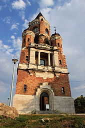
Attractions
Sports
Zemun is home to the football club FK Zemun .
Town twinning
Zemun maintains partnerships with Offenbach am Main in Hesse and Mödling in Lower Austria .
sons and daughters of the town
- Jakob Herzl (1835–1902), entrepreneur, father of Theodor Herzl
- Andreas Moser (1859–1925), German-Austrian violin teacher and close confidante of Joseph Joachim
- Victor Müller-Heß (1883–1960), German forensic doctor
- Rudolfo Franjin Magjer (1884–1954), Croatian writer
- Dora Pfanova (1897-1989), Croatian writer
- Josip Kulundžić (1899–1970), Croatian writer
- Theodor Balk (1900–1974, real name: Fodor Dragutin), German-Jewish writer
- Mirko Tepavac (1922–2014), Yugoslav politician
- Miloš Bandić (1930–1996), Croatian writer
- Vladica Popović (1935–2020), football player and coach
- Branko Samarovski (* 1939) actor
- Ljubomir Magaš (1948–1986), called Ljuba Zemunac, leader of an association of Yugoslav criminals
- Momčilo Bajagić Bajaga (* 1960), Serbian singer
- Dragan Dojčin (* 1976), Serbian basketball player
- Dejan Stanković (* 1978), Serbian football player
- Mateja Kežman (* 1979), Serbian football player
- Aleksandar Kolarov (* 1985), Serbian football player
Trivia
- The novel Die Ohrfeige (2007) by David Albahari is set largely in Zemun.
- In the song Prinz Eugen, the noble knight , Prince Eugene of Savoy sets up camp there to fight the Turks and recapture Belgrade.
Web links
- Official site (sr, en)
- Zemun Jewish Community (sr)
- Website of the Croatian cultural association "Matica hrvatska" about Zemun (hr)
Individual evidence
- ↑ Zemun. In: mirjanadetelic.com. Retrieved May 3, 2017 (Serbian).
- ↑ Publication point: The breakdown of the population of the former Yugoslavia according to mother tongue and denomination according to the unpublished information from the census of 1931. Edited and edited by the Publikationsstelle Wien. For official use only. Staatsdruckerei Wien, Vienna 1943, p. 23. Opšta Državna Statistika: Definitivni rezultati popisa stanovništva od 31 marta 1931 godine. Knjiga 2: Prisutno stanovništvo po veroispovesti . Državna Štamparija, Belgrade 1938, p. 124
- ↑ town twinning. From: offenbach.de, accessed on March 25, 2018.
Coordinates: 44 ° 51 ' N , 20 ° 25' E


