
Zulia
| Zulia | |||
|---|---|---|---|
 .svg) |
|||
| Symbols | |||
|
|||
| Basic data | |||
| Country | Venezuela | ||
| Capital | Maracaibo | ||
| surface | 63,100 km² | ||
| Residents | 4,199,200 (2017 estimate) | ||
| density | 67 inhabitants per km² | ||
| ISO 3166-2 | VE-V | ||
| politics | |||
| governor | Magdely Valbuena | ||
| Political party | PSUV | ||


Coordinates: 9 ° 58 ′ N , 72 ° 31 ′ W
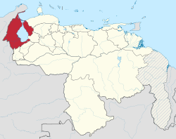
Zulia is one of the 23 states of Venezuela and is located in the northwest of the country on the border with Colombia . The capital is Maracaibo . The name comes from the name of a plant ( Männertreu , Latin Lobelia erinus) in a Chibcha language or refers to the river of the same name that flows into Lake Maracaibo in the southwest of the state .
The oil from the Lake Maracaibo (one of the largest reserves of oil and natural gas in the Western Hemisphere) where a large proportion of the country's revenue.
A good 60 percent of Venezuela's indigenous population live in Zulia. The proportion of the population of Zulia is just under 13 percent ( 2011 census ).
geography
Zulia has a long (and largely uninhabited) border with Colombia to the north and west, from the Guajira Peninsula to the Perijá Mountains. In the south it borders on the Venezuelan Andean states Táchira , Mérida and Trujillo and in the east on Lara and Falcón .
Within its limits is Lake Maracaibo, the largest lake in South America . According to the (controversial) legend, the stilt houses (palafitos), reminiscent of Venice, which the Añus (the indigenous indigenous people) had built over the water, gave Venezuela its name (Little Venice). To the north of this is the Gulf of Venezuela .
With 63,100 km², Zulia is the fifth largest state in the country.
Administrative division
Zulia is divided into 21 districts ( Municipios ):
|

economy
Zulia depends on the production of oil, which is carried out on a large scale (in Lake Maracaibo) (80% of the country's production comes from Zulia). Its sales are the main source of income for Venezuela.
In the south there is arable farming and animal husbandry, mainly palm oil, grapes , milk , cheese , beef and pork , poultry , but also bananas in many sizes and types, sugar cane , coconuts , cotton , beans and melons .
There is also extensive fishing in the waters of Zulia (Lake Maracaibo and Gulf of Venezuela).
Sons and daughters of the state
- Humberto Fernández Morán , scientist (* 1924; † 1999)
- Rafael Urdaneta , President of Greater Colombia 1823, 1824
- Rafael María Baralt, writer and journalist (* 1810; † 1860)
- Luis Aparicio , baseball player
Web links
Individual evidence
- ↑ Primeros Resultados Censo Nacional 2011: Población Indígena de Venezuela. National Statistics Institute, January 2013, accessed December 29, 2018.
States:
Amazonas |
Anzoátegui |
Apure |
Aragua |
Barinas |
Bolívar |
Carabobo |
Cojedes |
Delta Amacuro |
Falcón |
Guárico |
Vargas (La Guaira) |
Lara |
Mérida |
Miranda |
Monagas |
Nueva Esparta |
Portuguesa |
Sucre |
Táchira |
Trujillo |
Yaracuy |
Zulia
Capital District :
Distrito Capital
Federal immediate area:
Dependencias Federales