Together
| Together | ||
|
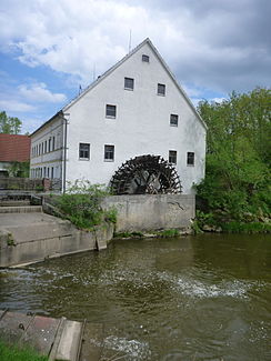
Together at Wiesmühle ( Villenbach ) |
||
| Data | ||
| Water code | EN : 1192 | |
| location | Bavarian Swabia | |
| River system | Danube | |
| Drain over | Danube → Black Sea | |
| source | at Markt Wald 48 ° 7 ′ 48 ″ N , 10 ° 34 ′ 23 ″ E |
|
| Source height | approx. 630 m above sea level NN | |
| muzzle | near Donauwörth coordinates: 48 ° 42 '35 " N , 10 ° 47' 39" E 48 ° 42 '35 " N , 10 ° 47' 39" E |
|
| Mouth height | approx. 395 m above sea level NN | |
| Height difference | approx. 235 m | |
| Bottom slope | approx. 2.9 ‰ | |
| length | 81 km | |
| Discharge at the Pfaffenhofen A Eo gauge : 505 km² Location: 14.9 km above the mouth |
NNQ (02/11/1932) MNQ 1932/2006 MQ 1932/2006 Mq 1932/2006 MHQ 1932/2006 HHQ (04/14/1994) |
1.1 m³ / s 2.48 m³ / s 4.49 m³ / s 8.9 l / (s km²) 29 m³ / s 74.6 m³ / s |
| Right tributaries | Roth | |
The Zusam is an approximately 80 km long right tributary of the Danube in Bavaria ( Germany ).
course
The source of the source is located in the perennials southwest of Markt Wald in the Unterallgäu district, near the state road 2026. In the source area, the stream still absorbs the middle zone and the drought zone . It always flows in a northerly direction via Ziemetshausen , Dinkelscherben , Zusmarshausen , Altenmünster , Villenbach , Wertingen and Buttenwiesen and flows into the Danube at Donauwörth .
The river runs 50 km in length - from the source to Buttenwiesen - in the Augsburg-Westliche Wälder Nature Park . The 115 km long Zusam cycle path leads from Kaufbeuren via Bad Wörishofen to the source, then downstream to Donauwörth .
etymology
A landscape name from 898 in pago Dúria ("in Gau Dúria") contains the old name of the river. This probably comes from the Savoyard word doron , which means "brook". In 1268 the name appears as Zvsma , 1269 as Zvsem , 1284 as Z e usme and 1524 as Zusam . This name corresponds to the Germanic tusma or the old Latin dusma ("the one covered with scrub").
Tributaries
- Middle togetherness (left)
- Drought together (left)
- Bernbächlein (left)
- Lauterbach (right)
- Schellenbach (right)
- Hittelsbachgraben (left)
-
Little Roth (right)
- Reichenbach (left)
- Brunnenwiesbach (left)
- Godlbach (right)
- Bettenbach (right)
- Hornbach (left)
-
Roth (right)
- Wollbach (left)
- Salenbach (right)
- Dellerbach (right)
- Heimenbach (left)
- Hinterbach (left)
- Münsterbach (left)
- Weldishofer Bach (right)
- Hennhofer Bach (left)
- Weisinger Forstbach (left)
- Fultenbach (left)
- Mollenbach (right)
- Weiherlebach (left)
- Aufbach (left)
-
Casting ditch , (left)
-
Laugna (right)
- Hohenreicher Mühlbach (right)
- Birketbach (right)
Web links
Individual evidence
- ^ Deutsches Gewässerkundliches Jahrbuch Danube region 2006 Bavarian State Office for the Environment, p. 118, accessed on October 4, 2017, at: bestellen.bayern.de (PDF, German, 24.2 MB).
- ↑ Wolf-Armin Frhr. von Reitzenstein : Lexicon of Bavarian place names. Origin and meaning . 2nd, improved and enlarged edition. Verlag CH Beck, Munich 1991, ISBN 3-406-35330-4 , p. 428.
