Brantice
Brantice | |
|---|---|
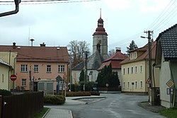
 Centre of Brantice | |
| Coordinates: 50°3′49″N 17°37′45″E / 50.06361°N 17.62917°E | |
| Country | |
| Region | Moravian-Silesian |
| District | Bruntál |
| First mentioned | 1222 |
| Area | |
| • Total | 26.73 km2 (10.32 sq mi) |
| Elevation | 341 m (1,119 ft) |
| Population (2023-01-01)[1] | |
| • Total | 1,370 |
| • Density | 51/km2 (130/sq mi) |
| Time zone | UTC+1 (CET) |
| • Summer (DST) | UTC+2 (CEST) |
| Postal code | 793 93 |
| Website | www |
Brantice (German: Bransdorf) is a municipality and village in Bruntál District in the Moravian-Silesian Region of the Czech Republic. It has about 1,400 inhabitants.
Administrative parts[edit]
The village of Radim is administrative part of Brantice.
Geography[edit]
Brantice is located about 14 kilometres (9 mi) northeast of Bruntál and 50 km (31 mi) northwest of Ostrava. It lies in the Nízký Jeseník range. The highest point is the hill Uhlák at 667 m (2,188 ft) above sea level. The built-up area lies in the valley of the Opava River.
History[edit]
The first written mention of Brantice is from 1222. In 1377, it became a part of the Duchy of Krnov.[2]
According to the Austrian census of 1910 the village had 1,211 inhabitants, 1,173 (99.8%) were German-speaking. Most populous religious group were Roman Catholics with 1,195 (98.7%).[3]
Demographics[edit]
|
|
| ||||||||||||||||||||||||||||||||||||||||||||||||||||||
| Source: Censuses[4][5] | ||||||||||||||||||||||||||||||||||||||||||||||||||||||||
Transport[edit]
The I/45 road (the section from Bruntál to Krnov) passes through the municipality.
Brantice is located on the railway line Ostrava–Moravský Beroun via Bruntál.[6]
Sights[edit]

The main landmark of Brantice is the Church of the Assumption of the Virgin Mary. It is a Renaissance-Baroque building with preserved sgraffito decoration on the tower.[7]
The Brantice Castle is a rural castle with a park. It was gradually built on the site of an older fortress from the 1670s to the beginning of the 19th century. Today it is privately owned and inaccessible.[8]
References[edit]
- ^ "Population of Municipalities – 1 January 2023". Czech Statistical Office. 2023-05-23.
- ^ "Historie a současnost obce, znak obce" (in Czech). Obec Brantice. Retrieved 2022-03-15.
- ^ Ludwig Patryn (ed): Die Ergebnisse der Volkszählung vom 31. Dezember 1910 in Schlesien, Troppau 1912.
- ^ "Historický lexikon obcí České republiky 1869–2011 – Okres Bruntál" (in Czech). Czech Statistical Office. 2015-12-21. pp. 1–2.
- ^ "Population Census 2021: Population by sex". Public Database. Czech Statistical Office. 2021-03-27.
- ^ "Detail stanice Brantice" (in Czech). České dráhy. Retrieved 2024-03-20.
- ^ "Kostel Nanebevzetí P. Marie" (in Czech). National Heritage Institute. Retrieved 2023-04-19.
- ^ "Zámek" (in Czech). National Heritage Institute. Retrieved 2023-04-19.


