
Cerro de la Silla
| Cerro de la Silla | |
|---|---|
 Cerro de la Silla in 2004 | |
| Highest point | |
| Elevation | 1,820 m (5,970 ft) |
| Prominence | 1.200 meters |
| Coordinates | 25°37′23″N 100°14′34″W / 25.62306°N 100.24278°W |
| Naming | |
| English translation | Saddle Hill |
| Language of name | Spanish |
| Pronunciation | Spanish pronunciation: [ˈsero ˌðelaˈsiʝa] |
| Geography | |
| Location | Guadalupe and Monterrey, Nuevo León, Mexico |
| Climbing | |
| Easiest route | Hiking |
The Cerro de la Silla is a mountain and natural monument located within the metropolitan area of the city of Monterrey, Nuevo León, in northeastern Mexico. Named for its distinctive saddle-shaped profile when viewed from the west, it is a well-known symbol of the city of Monterrey, despite being located in the adjacent municipality of Guadalupe.
It covers an area of 60.5 square kilometres (23 mi2). The mountain has four peaks: Pico Antena, Pico Norte, Pico Sur and Pico la Virgen; Pico Norte (North Peak) is the highest at 1,820 m (5,970 ft) while Pico la Virgen (Virgin's Peak) is the lowest at 1,750 m (5,740 ft).
Set aside as a natural monument by the Mexican government in 1991, the mountain, or hill, as mountains are often referred to in Mexico, is a popular recreational area and is often climbed by hikers who take a 5.3 km (3.3 mi) trail to reach the top. The ascent is considered to be fairly difficult, taking approximately 3 hours to complete. A panoramic view of the city of Monterrey can be seen from the top.
In the second half of the 20th century, an aerial tramway (Teleférico en Monterrey) was built on the north side of the mountain to give a fastest access to the iconic mountain for the population.[1] The day of its inauguration on June 2, 1961, was also the day of its closure, as a tragic accident took the lives of five people, including the engineer Jesús Fernández, its designer. Only the upper station remains of the tramway. Several plans have been announced to rebuild another tramway with no results.[citation needed]
Some other known mountains or elevations of the zone are: Cerro de las Mitras, the Sierra Madre Oriental with the Cerro de Chipinque —the M-shaped figure visible from various parts of the city—, the Cerro del Topo Chico, Cerro del Obispado, Cerro de la Loma Larga and La Huasteca.
Gallery[edit]
-
 Cerro de la Silla and Monterrey from space
 -
 Cerro de la Silla as seen from Cerro del Obispado
 -
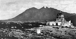 Palacio del Obispado and Cerro de la Silla, 1904
 -
 Clouds over Cerro de la Silla.


References[edit]
- ^ "The tragic Cerro de la Silla aerial tramway". 21 September 2011.
External links[edit]
- Cerro de la Silla information (Spanish)
- Mexico Desconocido (Spanish)