
Galiakot
This article needs additional citations for verification. (April 2015) |
Galiyakot
Wagad Taherabad | |
|---|---|
| Galiyakot | |
 Galiyakot Location in Rajasthan, India  Galiyakot Galiyakot (India) | |
| Coordinates: 23°32′10″N 74°00′32″E / 23.536°N 74.009°E | |
| Country | |
| State | Rajasthan |
| District | Dungarpur |
| Elevation | 145 m (476 ft) |
| Population (2001) | |
| • Total | 6,636 |
| Languages | |
| • Official | Hindi, Rajasthani, wagdhi |
| Time zone | UTC+5:30 (IST) |
| ISO 3166 code | RJ-IN |
Galiyakot is a town in Dungarpur District of Rajasthan, India.[1] It is situated about 56 km from Dungarpur city and 168km from the Rajasthan city of Udaipur. According to the available history, this town was the property of Parmar dynasty around Vikram Samvat 1000. In Vikram Samvat 1342, Rao Dedu (Devpal) Raja of Sisodiya dynasty subdued Galiyakot. The ancestors of Dungarpur state ruled over Galiyakot for many years and with time, due to circumstances, they settled in Dungarpur. It is also a Dawoodi Bohra pilgrimage site.There are many Hindu temples here. The town is famous for the shitla mata mandir and tomb of babjee moula syedi fakhruddin. near the river there is a temple of Mahadev about 1000 years old.
Geography[edit]
Galiakot is located at 23°32′10″N 74°00′32″E / 23.536°N 74.009°E. It has an average elevation of 145 metres (475 feet).
Demographics[edit]
As of 2001[update] India census, Galiakot had a population of 6,636.[2] Males constitute 51% of the population and females 49%. Galiakot has an average literacy rate of 56%, lower than the national average of 59.5%: male literacy is 67%, and female literacy is 44%. In Galiakot, 17% of the population is under 6 years of age. This place was also known or famous for Ramkada udhyog.
Photo gallery[edit]
-
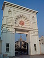
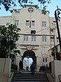 Dargah entrance
 -
 Dargah Compound
 -
 Entrance Mausoleum
 -
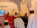 Grave Fakhruddin Shaheed
 -
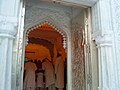
 Mosque Fakhri Mazar
 -
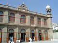
 Main entrance, Fakhri mazar
 -
 Garden for children, Fakhri mazar
 -
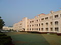
 Residential complex for visitors Fakhri mazar
 -
 Dining hall, Fakhri Mazar
 -
 Residence Moulai Fakhruddin renovated
 -
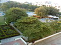 Gardens Fakhri Mazar
 -
 Residential complex 2


Notes and references[edit]
- ^ Census Commission of India. "Galiakot Population Census 2011". Census 2011. Archived from the original on 17 April 2015.
- ^ "Census of India 2001: Data from the 2001 Census, including cities, villages and towns (Provisional)". Census Commission of India. Archived from the original on 16 June 2004. Retrieved 1 November 2008.