
Luštěnice
Luštěnice | |
|---|---|
 Aerial view | |
 Flag  Coat of arms | |
 Luštěnice Location in the Czech Republic | |
| Coordinates: 50°19′23″N 14°56′12″E / 50.32306°N 14.93667°E | |
| Country | |
| Region | Central Bohemian |
| District | Mladá Boleslav |
| First mentioned | 1268 |
| Area | |
| • Total | 14.78 km2 (5.71 sq mi) |
| Elevation | 209 m (686 ft) |
| Population (2023-01-01)[1] | |
| • Total | 2,234 |
| • Density | 150/km2 (390/sq mi) |
| Time zone | UTC+1 (CET) |
| • Summer (DST) | UTC+2 (CEST) |
| Postal code | 294 42 |
| Website | www |
Luštěnice is a municipality and village in Mladá Boleslav District in the Central Bohemian Region of the Czech Republic. It has about 2,200 inhabitants.
Administrative parts[edit]
The villages of Voděrady and Zelená are administrative parts of Luštěnice.
Geography[edit]
Luštěnice is located about 10 kilometres (6 mi) south of Mladá Boleslav and 38 km (24 mi) northeast of Prague. It lies in the Jizera Table. The highest point is at 241 m (791 ft) above sea level. The Vlkava River flows through the municipality.
History[edit]
The first written mention of Luštěnice is from 1268. From 1570 to 1739, the village was part of the Kosmonosy estate, owned were the Czernin family. In 1739, Luštěnice was purchased by Josef Scherzer of Kleinmühl. He has the baroque Luštěnice Castle built around 1740. The Gallas family owned the village from 1774 to 1805, then they sold it to the Nostitz family.[2][3]
Demographics[edit]
|
|
| ||||||||||||||||||||||||||||||||||||||||||||||||||||||
| Source: Censuses[4][5] | ||||||||||||||||||||||||||||||||||||||||||||||||||||||||
Transport[edit]
The I/38 road (the section from Mladá Boleslav to Nymburk) passes through the municipality.
Luštěnice is located on the railway line Mladá Boleslav–Nymburk.[6]
Sights[edit]
The main landmark of Luštěnice is the Church of Saint Martin. It is a Baroque church from 1739 that replaced the old parish church.[2][7]
The Luštěnice Castle is a late Baroque building from the 18th century, built on the site of an old fortress. From 1805, the castle was used as an administrative building and fell into disrepair. Today it is unused, but it is gradually being repaired.[3][8]
Gallery[edit]
-
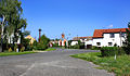
 Boleslavská street
 -
 Church of Saint Martin and the castle
 -
 The village of Voděrady


References[edit]
- ^ "Population of Municipalities – 1 January 2023". Czech Statistical Office. 2023-05-23.
- ^ a b "Historie obce" (in Czech). Obec Luštěnice. Retrieved 2023-01-24.
- ^ a b "Historie" (in Czech). Luštěnice Castle. Retrieved 2023-01-24.
- ^ "Historický lexikon obcí České republiky 1869–2011 – Okres Mladá Boleslav" (in Czech). Czech Statistical Office. 2015-12-21. pp. 11–12.
- ^ "Population Census 2021: Population by sex". Public Database. Czech Statistical Office. 2021-03-27.
- ^ "Detail stanice Luštěnice" (in Czech). České dráhy. Retrieved 2024-02-09.
- ^ "Kostel sv. Martina" (in Czech). National Heritage Institute. Retrieved 2024-04-06.
- ^ "Zámek" (in Czech). National Heritage Institute. Retrieved 2023-01-24.
External links[edit]
| Authority control databases: National |
|---|