
Peniki
Peniki
Пеники | |
|---|---|
Village | |
_Rural_Settlement.png) Flag _Rural_Settlement_2nd.png) Coat of arms | |
| Etymology: From Finnish penikka – "a puppy" | |
| Coordinates: 59°55′03″N 29°38′31″E / 59.91750°N 29.64194°E | |
| Country | Russian Federation |
| Oblast | Leningrad Oblast |
| District (raion) | Lomonosovsky District |
| Rural Settlement | Penikovskoye Rural Settlement or Peniki Rural Settlement |
| Population (2010)[2] | |
| • Total | 1,207 |
| Time zone | UTC+03:00 |
| Zip Code | 18853 |
| Website | peniki47 |
Peniki (Russian: Пе́ники, tr. Péniki, IPA: [ˈpʲenʲɪkʲɪ] ⓘ, Finnish: Penikkala[1]) is a rural locality (a village) in Lomonosovsky District of Leningrad Oblast, Russia. Municipally, it is a part and the administrative center of Penikovskoye Rural Settlement.
Name of the village[edit]
The village was founded between 1763 and 1782.[3] During the Emancipation Reform of 1861 in the Russian Empire, the local Orthodox priest Vasily wrote a description of the poverty and profiteering of the country's folks, which has been preserved.[4] The priest often reports about the peasants, so the landlords knew all about their faults.[4]
At this time, a manor was built here, at which the owner bred hounds and sold puppies. It is from this enterprise that the town's name derives - Peniki (Penniki, Penikkala), which is from the Finnish word penikka, which means "a puppy."
Climate[edit]
The climate in the village of Peniki is close to a cool temperate climate with moderately warm summers and moderately cold winters. Under the Köppen climate classification, Peniki is classified as Dfb, a humid continental climate. The winters are warmer here than in Moscow due to its closeness to the Gulf of Finland. The Gulf of Finland is located just 1 km from the center of the village. The average maximum temperature in July is 22 °C (71.6 °F), and the average minimum temperature in February is −10.5 °C (13.1 °F). Average annual precipitation is 669 millimeters (26.338 in) per year.[5]
| Month | Jan | Feb | Mar | Apr | May | Jun | Jul | Aug | Sep | Oct | Nov | Dec | Year |
|---|---|---|---|---|---|---|---|---|---|---|---|---|---|
| Daily mean °F | 23.0 | 24.1 | 32.7 | 46.0 | 59.5 | 68.5 | 71.6 | 68.2 | 57.6 | 45.9 | 34.3 | 27.7 | 46.7 |
| Mean daily minimum °F | 13.1 | 13.1 | 20.3 | 31.6 | 41.7 | 51.4 | 55.2 | 52.9 | 44.8 | 36.3 | 27.5 | 18.7 | 33.8 |
| Average precipitation inches | 1.57 | 1.22 | 1.41 | 1.45 | 1.61 | 2.48 | 2.99 | 3.26 | 2.95 | 2.67 | 2.51 | 2.16 | 26.338 |
| Daily mean °C | −5.0 | −4.4 | 0.4 | 7.8 | 15.3 | 20.3 | 22.0 | 20.1 | 14.2 | 7.7 | 1.3 | −2.4 | 8.2 |
| Mean daily minimum °C | −10.5 | −10.5 | −6.5 | −0.2 | 5.4 | 10.8 | 12.9 | 11.6 | 7.1 | 2.4 | −2.5 | −7.4 | 1.0 |
| Average precipitation mm | 40 | 31 | 36 | 37 | 41 | 63 | 76 | 83 | 75 | 68 | 64 | 55 | 669.0 |
| Source: Climate-Data.org[5] | |||||||||||||

History[edit]
This section may be a rough translation from Russian. It may have been generated, in whole or in part, by a computer or by a translator without dual proficiency. (August 2022) |


Thus, the territory of the Lomonosov district of the Leningrad region (including the territory of the modern Peniki) was the property of Sweden. It was the historical region of Ingria in the period of 1617–1721. Then the territory was returned to Russian Empire.
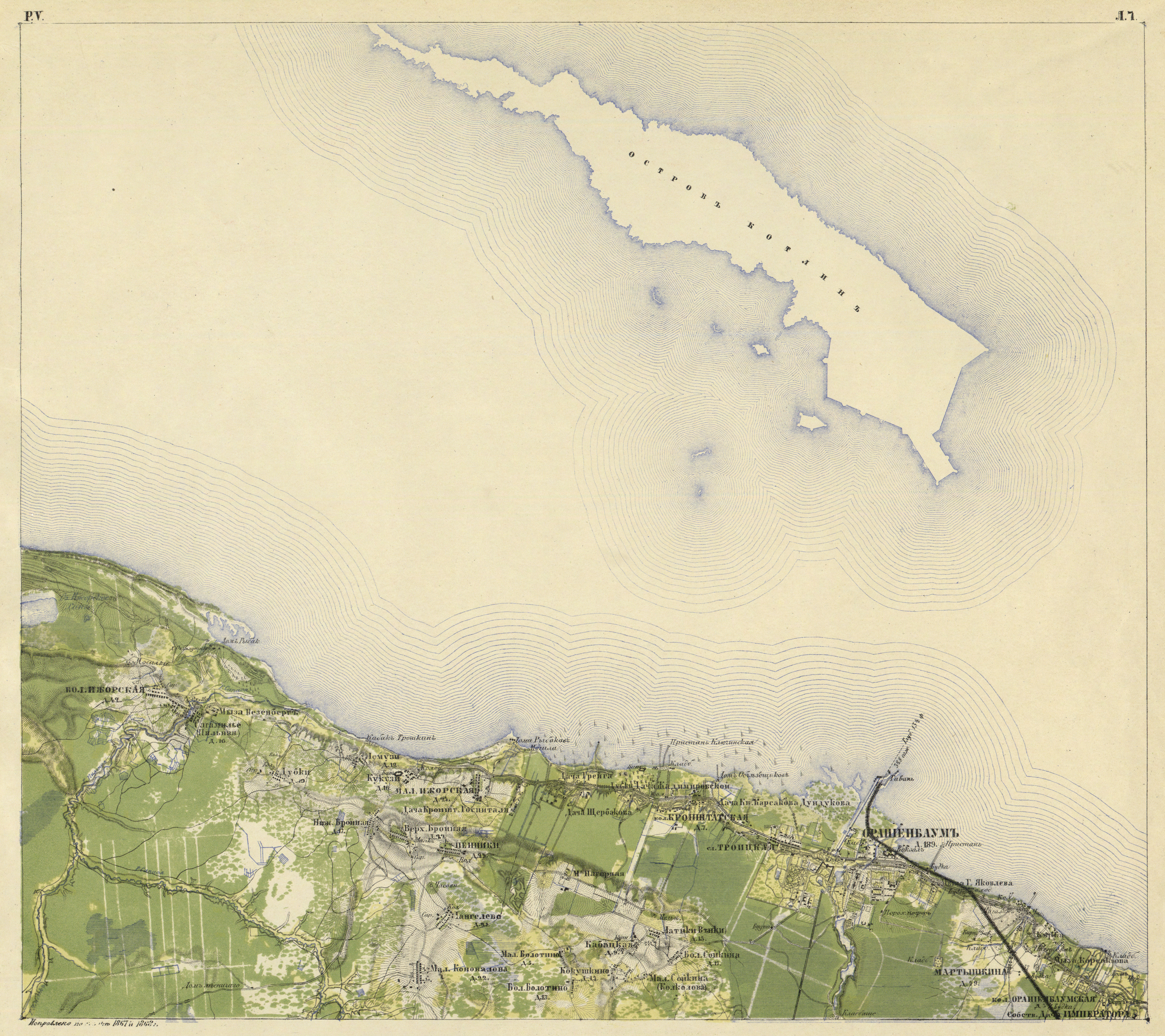
The village of Peniki is marked on the Semi-topographical map of 1810.[6]
On the "Topographic Map of the Neighborhoods of Saint Petersburg" of the Military Topographic Depot of the General Staff of 1817, the village of Peniki is mentioned. It further provides that in Peniki were 16 households.[7]
The village of Peniki with 16 households is also mentioned on the "Topographical map of the environs of St. Petersburg" by Friedrich von Schubert in 1831:[8]
Peniki is a village which belongs to the Grand Duke Mikhail Pavlovich, the number of inhabitants by the revision: 44 males, 48 females (1838 year).[9]
As indicated in the explanatory text to the ethnographic map of Saint Petersburg Governorate by P. I. Köppen of 1849, it is recorded as the village of Penikkala (Penniki, Peniki) and indicates the number of its inhabitants for 1848: Ingrians-Äyrämöisets – 11 m., 15 f., Ingrians-Savonians – 16 m., 17 f., Izhorians – 32 m., 33 f., total population is 124 people.[10]
In 1860, the village of Peniki had 25 households.[11]
On the map of 1863 the village is marked as Penniki, but on the map drawn in 1925, the name Peniki started being used.
By 1913 the number of households increased to 35.[12]
According to the topographic map of 1939, the village had 70 households.
By ethnic nationality, the overwhelming majority of the village population after the year 1942, were Russians. The indigenous population – Izhorians and Ingrians - were deported and repressed by Stalin. Presently, however, they are fully assimilated in Russian society.
Geography[edit]
The village is located in the northern part of the area near the southern shore of the Gulf of Finland, to the west of the city Lomonosov. and to the east of the village Bolshaya Izhora. The distance to the raion center is 9 km.[13] It is also 2 kilometers away from the nearest railway station in Bronka.[14]
Demography[edit]

Communications infrastructure[edit]
The Peniki village has two Internet service providers (ISP) providing high-speed Internet. These are Viartcom and Freedom House. Telecommunication is also available and the telephone dialing code of the village is +7 813-7654 (+7 – Russian country calling code, 813 – Leningrad Oblast code).
Transportation[edit]
There is a bus transportation available (buses No. 691 and No. 691A). In addition to bus transportation, there is a fixed-route taxi K-502 (Lomonosov→Malaya Izhora→Peniki→Dubki→Bolshaya Izhora and Bolshaya Izhora→Dubki→Peniki→Malaya Izhora→Lomonosov). A part of the Saint Petersburg Ring Road (the western half-ring) also passes through the territory of the Penikovskoye Rural Settlement.
References[edit]
- ^ a b P. Mikkonen, M. Kahla, I. Kempinen, A. Charnaya (2006). Venäjän federaation paikannimiä [Place names of the Russian Federation] (PDF) (in Finnish). Helsinki. p. 180. ISBN 952-5446-18-2.
{{cite book}}: CS1 maint: location missing publisher (link) CS1 maint: multiple names: authors list (link) - ^ "Итоги Всероссийской переписи населения 2010 года. Ленинградская область" [Results of the 2010 All-Russian Population Census. Leningrad Oblast.]. Управление Федеральной службы государственной статистики по г. Санкт-Петербургу и Ленинградской области (Russian Federal State Statistics Service of St. Petersburg and Leningrad Oblast). Archived from the original on July 25, 2017. Retrieved March 18, 2018. (RAR archive)
- ^ Central State Historical Archive of St. Petersburg (CGIA SPb), 1729-1-52. On the attribution of the church servant I. I. Beckman to the state peasants of the Oranienbaum district. Page 26: an extract from the 1782 revision list.
- ^ a b "Ломоносов — История города" [Lomonosov – History of the City] (in Russian). Archived from the original on 2008-01-24.
- ^ a b Климат: Пеники (in Russian). Climate-data.org. Retrieved March 6, 2018.
- ^ "Semitopographic map of the circumference of St. Petersburg and the Karelian Isthmus" Семитопографическая карта окружности С. Петербурга и Карельского перешейка 1810 года [Semi-topographical map of the circle of St. Petersburg and the Karelian Isthmus of 1810] (in Russian).
- ^ «Топографическая карта окружности Санкт-Петербурга» на 16 листах в масштабе 1 в. в 1 дм или 1 : 42 000, Военно-топографическое депо Главного штаба, 1817 г. (in Russian)
- ^ «Топографическая карта окрестностей Санкт-Петербурга», снята под руководством генерал-лейтенанта Шуберта и гравирована при военнотопографическом депо. 1831 год. (in Russian)
- ^ Описание Санкт-Петербургской губернии по уездам и станам [Description of the Saint Petersburg Governorate by uyezds and stans] (in Russian). 1838. p. 142.
- ^ Köppen P. von. Erklarender Text zu der ethnographischen Karte des St. Petersburger Gouvernements. – St. Petersburg, 1867 – P. 39, 73. (in German)
- ^ Карта Санкт-Петербургской губернии. 1860 г. [Map of the Saint Petersburg Governorate. 1860 year.] (in Russian).
- ^ «Карта района манёвров» 1913 г. (in Russian)
- ^ Административно-территориальное деление Ленинградской области. – Лениздат, 1990, ISBN 5-289-00612-5, P. 85
- ^ Сост. Т. А. Бадин, ed. (1966). Административно-территориальное деление Ленинградской области (PDF) (in Russian). Leningrad: Lenizdat. p. 149. Archived from the original (PDF) on 17 October 2013.
External links[edit]
 Media related to Peniki at Wikimedia Commons
- Official site of the Peniki Rural Settlement (in Russian)