
Sudargas
Sudargas | |
|---|---|
Village | |
 Square by the Catholic Church | |
 Coat of arms | |
 Sudargas | |
| Coordinates: 55°2′31.2″N 22°38′27.6″E / 55.042000°N 22.641000°E | |
| Country | |
| County | |
| Municipality | |
| Elderate | Sudargas elderate |
| Population (2021) | |
| • Total | 33 |
| Time zone | UTC+2 (EET) |
| • Summer (DST) | UTC+3 (EEST) |
| Website | www |
Sudargas is a village located in Šakiai district, west Lithuania.
History[edit]
In the Middle Ages, it was one of the strongest defence centres of the region during the war with the Teutons, and it was the site of the Samogitian Sudargas Castle, which was burnt down by the Teutons on 24 June 1317. After that, the area disappeared for a long time. It was not until the beginning of the 16th century, when the Queen of Poland and Grand Duchess of Lithuania began to colonise the Panemünė region, that the settlement began to grow.[1]
The village is mentioned in 1561.
In 1724, Jonas Mikalojus Radvila, secured the rights of the town from the Grand Duke of Lithuania, and was allowed to have a market and to organise two fairs.
In 1748, a wooden church was built in Sudargas.
On 12 May 1792, Stanisław II August granted the town rights and coat of arms.
In 1795, Sudargas was ceded to Prussia and later to Poland.
In 19th century, Sudargas was an important centre of book smuggling, with a large flow of printed materials passing through the parish priest Martynas Sederevičius. Sudargas lost its town rights on 28 August 1870. At the end of the 19th century, it is mentioned as a settlement of Naumiestis county in the Kiduliai parish.[2]
In 2000, coat of arms of Sudargas was adopted.
In 2003, the Sudargas Community Centre was established.[1]
Archaeology[edit]
The Sudargas mound complex (a.k.a. the Grinaičiai mound complex) has two mounds: Grinaičiai I a.k.a. Balnakalnis and Grinaičiai II a.k.a. Žydkapiai. It adjoins the Burgaičiai mound complex, which includes 3 mounds: Burgaičiai I (a.k.a. Vorpilis), Burgaičiai II (a.k.a Pilaitė), and Burgaičiai III.
Demography[edit]
| Year | 1888 | 1923 | 1959 | 1970 | 1979 | 1982 | 1987 | 1989 | 2001 | 2011 | 2021 |
|---|---|---|---|---|---|---|---|---|---|---|---|
| Population | 932[3] | 257 | 119[4] | 91 | 71[5] | 70 | 72 | 77[6] | 85[7] | 35 | 33[8] |
Gallery[edit]
-
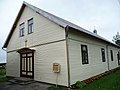
 Eldership in Sudargas
 -
 Church of St. John the Baptist
 -
 A school in Sudargas


References[edit]
- ^ a b "Apie seniūniją - Lietuvos savivaldybių seniūnų asociacija". www.seniunai.lt (in Lithuanian). Archived from the original on 26 April 2016.
- ^ "Słownik geograficzny Królestwa Polskiego i innych krajów słowiańskich, Tom XI - wynik wyszukiwania - DIR". dir.icm.edu.pl.
- ^ Wolter, Eduard / Вольтер (1901). "Списки населенныхъ местъ Сувалкской губерніи, какъ матеріалъ для историко-этнографической географіи края". Retrieved 30 April 2023.
- ^ "Lietuvos TSR kaimo gyvenamosios vietovės 1959 ir 1970 metais (Visasąjunginių gyventojų surašymų duomenys)" (PDF). Centrinė statistikos valdyba prie Lietuvos TSR Ministrų tarybos. 1974.
- ^ "Lietuvos TSR kaimo gyvenamosios vietovės (1979 metų Visasąjunginio gyventojų surašymo duomenys)" (PDF). Lietuvos TSR Centrinė statistikos valdyba. 1982.
- ^ "Kaimo gyvenamosios vietovės (1989 metų Visuotinio gyventojų surašymo duomenys)" (PDF). Lietuvos Respublikos Statistikos departamentas. 1993.
- ^ "MARIJAMPOLĖS APSKRITIES KAIMO GYVENAMOSIOS VIETOVĖS IR JŲ GYVENTOJAI".
- ^ "Rodiklių duomenų bazė - Oficialiosios statistikos portalas". osp.stat.gov.lt. Retrieved 30 April 2023.
External links[edit]
![]() Media related to Sudargas at Wikimedia Commons
Media related to Sudargas at Wikimedia Commons

This Marijampolė County, Lithuania location article is a stub. You can help Wikipedia by expanding it. |