
Wotton-under-Edge
| Wotton-under-Edge | |
|---|---|
 Church of St Mary the Virgin, Wotton-under-Edge | |
 Wotton-under-Edge Location within Gloucestershire | |
| Population | 5,632 (2021 Census)[1] |
| OS grid reference | ST758933 |
| District | |
| Shire county | |
| Region | |
| Country | England |
| Sovereign state | United Kingdom |
| Post town | WOTTON-UNDER-EDGE |
| Postcode district | GL12 |
| Dialling code | 01453 |
| Police | Gloucestershire |
| Fire | Gloucestershire |
| Ambulance | South Western |
| UK Parliament | |
Wotton-under-Edge /ˈwʊtən/ is a market town and civil parish in the Stroud district of Gloucestershire, England. Near the southern fringe of the Cotswolds, the Cotswold Way long-distance footpath passes through the town.
History[edit]

The first record of the town is in an Anglo-Saxon Royal Charter of King Edmund I, who in AD 940 leased four hides of land in Wudetun to Eadric.[2] The name Wudetun means the enclosure, homestead or village (tun) in or near the wood (wude). The "Edge" refers to the limestone escarpment of the Cotswold Edge which includes the hills of Wotton Hill and Tor Hill that flank the town. In the 1086 Domesday Book listing, Wotton was in the hundred of Dudstone.[3] Kingswood Abbey was founded in 1139,[4] but all that remains is a 16th-century Cistercian gatehouse. Nearby historical buildings include the Tudor houses of Newark Park and Owlpen Manor, both open to the public at set times. The medieval former public house The Ancient Ram Inn dates back to 1145.[5] The original town was burnt down during the reign of King John (1199–1216); it was rebuilt in 1252 and a charter granted to Johanna de Berkeley authorising her to hold a market and a three-day annual fair on the Feast of the Cross. In 1272 the inhabitants of the borough were authorised to elect one of their members as a Mayor, a practice that continued every year until 1886.[6][7]
St. Mary the Virgin was consecrated in 1283, and is the oldest and largest church in the town.[8] The Katharine Lady Berkeley's Grammar School was established in 1384 and is now a comprehensive named Katharine Lady Berkeley's School although the present modern building is a little outside of the town on the way to the village of Kingswood. The British School was established in the village in 1835.
The Battle of Nibley Green occurred near the Ancient Ram Inn in 1470 (or 1469 under the calendar of the time), when the building was owned by Thomas Talbot, 2nd Viscount Lisle. William de Berkeley, 1st Marquess of Berkeley led the forces that beat the Viscount, and after the battle his men sacked the manor. Overlooking the town on the top of Wotton Hill are a collection of trees planted in the 19th century to commemorate the Battle of Waterloo. These are situated on the site that housed one of the early warning beacons used to warn England of the approach of the Spanish Armada in 1588.[9]

New Mills, founded in 1810, prospered by supplying both sides in the Napoleonic wars but after a century of decline the mill was near to closing in 1981 when it was acquired by Renishaw plc.[10]
Wotton-under-Edge Town Hall was substantially rebuilt in 1872.[11] The town's corporation status was abolished in 1886 following the Municipal Corporations Act of 1883.[12]
Governance[edit]
An electoral ward with the same name exists. The ward mainly covers Wotton-under-Edge but also stretches to North Nibley. The total population of the ward taken at the 2011 census was 6,510.[13]
Facilities[edit]
The town has several pubs and a hotel, and a range of takeaways and restaurants. It has several active social groups, such as Scouts,[14] a gardening club[15] and the Wotton Lions.[16] In 1958, local people and school students built the town swimming pool, which was completed in 1961.[17] Subsequently the pool has had solar and electric heating installed. In 1999 with the fund raising support of community groups, a retractable enclosure was fitted to prolong the swimming season.[18] In 2015, a skate park was opened to improve sporting facilities in the town, with traffic-free paved access.[19]
In 2002, following the closure of the local cinema, a group of volunteers raised funds for a refurbishment to become one of the first digital cinemas in the UK.[20] It re-opened in 2005 as a 100-seat facility inside an old stable yard, once part of the Crown Inn which closed in 1911. Films were first shown in the old Banqueting Hall of the Inn and moved to the stable yard some years later, due to the popularity of films. The Wotton Electric Picture House (the original name) is now a thriving venue.[20]
On the hills immediately to the east, the Wotton-under-Edge BT Tower formed part of the microwave communication network between Bristol, Corsham and London during the Cold War before decommissioning, and remains a prominent local landmark (albeit without its distinctive horn aerials). Nearby Newark Park is operated by the National Trust as a heritage attraction within walking distance of the town, along with the Neolithic long barrow on a prominent position atop Blackquarries Hill.[21]
Media[edit]
Local news and television programmes are provided by BBC West and ITV West Country. Television signals are received from the Mendip TV transmitter. Local radio stations are BBC Radio Gloucestershire, Heart West, Greatest Hits Radio South West and Edge Radio, a community based station which started broadcasting during the COVID-19 pandemic in 2020. [22] The town is served by the local newspaper, Gazette Series. [23]
Transport[edit]
Road[edit]
Wotton-under-Edge is on the B4058 road and is 5 miles (8.0 km) from the M5 motorway.
Rail[edit]
Brunel's Bristol and Gloucester Railway passes within 2 miles (3.2 km) of Wotton-under-Edge, following a curve to the west to stay on the gentler Vale of Berkeley and avoid Wotton Hill, Nibley Knoll and Stinchcombe Hill as it heads north. It carries a wide mix of local, intercity and freight trains.
Charfield station, just to the west on flatter ground, was within walking distance from its opening in 1844. A branch line from Charfield to Wotton was authorised in 1899 under the Light Railways Act,[24] but never constructed.
Charfield station closed in 1965 during the Beeching cuts, leaving Wotton with no rail access.
Following the successful reopening of neighbouring Yate in 1989 and Cam & Dursley in 1994, plans to reopen Charfield station were developed by the West of England Combined Authority in 2021; a planning application was submitted in September 2022,[25] with planning permission granted in March 2023.[26] A "Greenway" is also proposed to allow traffic-free walking and cycling between Wotton, Kingswood and Charfield.[27]
The nearest railway station to the town is Cam & Dursley, 7 miles (11 km) from the town centre.
Bus[edit]
Bus services link the town to Charfield, Dursley, Yate, Chipping Sodbury, Nailsworth, Stroud, and Thornbury, but run infrequently.[28] Wotton is not part of WECA, but Katherine Lady Berkeley's school is served by the WESTlink on-demand bus, a short walk from the town centre and available to the public Monday-Saturday.[29]
Hiking routes[edit]
- The Cotswold Way follows a route down Wotton Hill and through the centre of the town, making it a popular stopover with hikers.
- The Slow Ways traffic-free accessible walking project connects Wotton to Dursley, Yate, Thornbury, Tetbury and Sherston.[30]
- The Monarch's Way passes within 2.5 miles (4.0 km) of Wotton through nearby Tresham and Hawkesbury Upton.[31]
Gallery[edit]
-
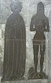 Monumental brass of Thomas de Berkeley, 5th Baron Berkeley (d.1417), Church of St Mary the Virgin
 -
 The Ancient Ram Inn
 -
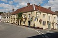 The Falcon Inn
 -
 The Tolsey clock commemorates the Diamond Jubilee (60 years) of Queen Victoria's reign. The clock says "1837 – 1897". It lies between Market Street and High Street.


Notable people[edit]
- More Adey (1858–1942) – art critic[32]
- Ian Alexander – footballer[33]
- Thomas de Berkeley, 5th Baron Berkeley (d.1417)[34]
- John Biddle – Unitarian[35]
- Charles Blagden – physician[36]
- Sophie Brzeska – writer.
- Bruce Chatwin – writer. Chatwin and his wife Elizabeth owned the house Holwell Farm from the mid-1960s to the 1980s.[37]
- Ann Dinham – born Ann Orchard, later Ann Riddiford and then Ann Foster; exiled to Tasmania in 1851 for "inciting a burglary".
- U. A. Fanthorpe – poet[38]
- Sir Matthew Hale – Lord Chief Justice (1671–1676)[39]
- Matthew Blagden Hale – bishop[39]
- Evan Hayward – Member of Parliament[40]
- Mark Horton – archaeologist[41]
- Catherine Johnson – playwright[42]
- Richard Knill – missionary
- James Lees-Milne and his wife Alvilde Lees-Milne - writers, lived at Alderley Grange for 13 years during the 1960s and 70s.
- Ian MacDonald (1948–2003) – music critic and author[43]
- Sir Isaac Pitman – creator of Pitman Shorthand, Pitman Place is named after him[44]
- Mark Porter – doctor[45]
- Sean Rigg – footballer[46]
- Jamie Stephens – footballer[47]
Further reading[edit]
- E. S. Lindley. Wotton under Edge: Men and Affairs of a Cotswold Wool Town. Published by Museum Press, 1962
- Simon Herrick. Under the Hill. (1979). ISBN 0-904387-36-4
References[edit]
- ^ "WOTTON". City population. Retrieved 25 October 2022.
- ^ "Anglo-Saxon Charters". Archived from the original on 2 April 2012. Retrieved 16 September 2011.
- ^ http://opendomesday.org/place/SO8520/wotton/ Open Domesday: Wotton
- ^ "Deeds of Kingswood Abbey". Archives Hub. Archived from the original on 27 August 2020. Retrieved 27 August 2020.
- ^ "Stroud District Council" (PDF). Archived from the original (PDF) on 27 September 2012. Retrieved 14 March 2013.
- ^ Wright, William Horace (1872). Historical Notes Relating to the Borough of Wotton,, And a List of Mayors of the Borough from 1660. Archived from the original on 27 August 2020. Retrieved 3 December 2017.
- ^ Rudge, Thomas (1803). The history of the county of Gloucester. Gloucester, Printed for the author by G. F. Harris. p. 249.
- ^ "Director of Music and Organist" (PDF). St Mary the Virgin, Wotton-under-Edge. Archived (PDF) from the original on 27 August 2020. Retrieved 27 August 2020.
- ^ "Wotton-under-Edge Wedding Fairs". Gloucestershire Wedding Fairs. Archived from the original on 27 August 2020. Retrieved 27 August 2020.
- ^ "Tubbs Online". Tubbs Lewis & Company. Archived from the original on 27 August 2020. Retrieved 27 August 2020.
- ^ Historic England. "Town Hall (1341570)". National Heritage List for England. Retrieved 20 September 2023.
- ^ Municipal Corporations Act 1883 (46 & 46 Vict. Ch. 18) (PDF). 1883. Retrieved 21 December 2021.
- ^ "Ward population 2011". Retrieved 31 March 2015.
- ^ "www.wottonscoutgroup.org – 1st Wotton-under-Edge Scout Group Log in". www.wottonscoutgroup.org. Archived from the original on 23 September 2009.
- ^ "Gloucestershire Federation of Gardening Societies". Archived from the original on 27 August 2020. Retrieved 4 March 2019.
- ^ "Wotton Lions | Serving our community". Archived from the original on 27 August 2020. Retrieved 4 March 2019.
- ^ "Construction and early years". Wotton Pool. Archived from the original on 27 August 2020. Retrieved 27 August 2020.
- ^ Wotton Swimming Pool Ltd. "Wotton Pool". Wotton Pool. Archived from the original on 15 August 2010. Retrieved 14 March 2013.
- ^ "Wotton Skate Park". Wotton Community PARC. Retrieved 13 April 2022.
- ^ a b "The Electric Picture House – A Short History". The Electric Picture House. Archived from the original on 27 August 2020. Retrieved 27 August 2020.
- ^ "MNA140747 | Blackquarries Hill Long Barrow, Newark Park, Glos". National Trust Heritage Records. Retrieved 20 February 2023.
- ^ Airey, Matty (16 April 2020). "Wotton's new radio station set to entertain through lockdown". Gazette Series. Retrieved 27 March 2024.
- ^ "Gloucestershire County Gazette". British Papers. 10 June 2014. Retrieved 27 March 2024.
- ^ "Wotton-under-Edge Light Railway". catalogue.gloucestershire.gov.uk. Retrieved 30 April 2023.
- ^ "Charfield train station". South Gloucestershire Council. Retrieved 20 February 2023.
- ^ jw47 (7 March 2023). "Charfield Station plans approved". Newsroom. Retrieved 30 April 2023.
{{cite web}}: CS1 maint: numeric names: authors list (link) - ^ "Housebuilder in Charfield donates funds to support Greenway project". Gazette Series. Retrieved 30 April 2023.
- ^ "Wotton-under-Edge". bustimes.org. Retrieved 20 February 2023.
- ^ "Home". WESTlink. Retrieved 5 June 2023.
- ^ "Slow Ways has the walks for Wotton-under-Edge, Stroud, Gloucestershire, England". beta.slowways.org. Retrieved 13 April 2022.
- ^ "Waymarked Trails - Hiking". hiking.waymarkedtrails.org. Retrieved 30 April 2023.
- ^ Sorensen, Lee. "Adey, More". Dictionary of Art Historians. Archived from the original on 27 August 2020. Retrieved 3 July 2018.
- ^ "Where Are They Now? Bristol Rovers Division Three Champions 1989–90". The football league paper. 24 March 2017. Archived from the original on 27 August 2020. Retrieved 27 August 2020.
- ^ "Thomas de Berkeley, 5th Baron Berkeley". Geni. Archived from the original on 27 August 2020. Retrieved 27 August 2020.
- ^ Chisholm, Hugh, ed. (1911). . Encyclopædia Britannica. Vol. 3 (11th ed.). Cambridge University Press.
- ^ "Sir Charles Blagden". Oxford Reference. Archived from the original on 27 August 2020. Retrieved 27 August 2020.
- ^ Yanagihara, Hanya (7 September 2017). "Bruce Chatwin: One of the Last Great Explorers". New York Times. Retrieved 27 August 2020.
- ^ Walker, Skip (6 May 2009). "Tributes are paid to poet UA Fanthorpe". Gazette. Archived from the original on 27 August 2020. Retrieved 27 August 2020.
- ^ a b "Hale Family of Alderley". National Archives. Archived from the original on 27 August 2020. Retrieved 27 August 2020.
- ^ Griffiths, Bill. "First World War Heroes of Wotton-under-Edge" (PDF). Wotton Heritage. Archived (PDF) from the original on 27 August 2020. Retrieved 27 August 2020.
- ^ "America's first Thanksgiving (1619)". Wotton-under-Edge Historical Society Museum & Heritage Centre. Archived from the original on 27 August 2020. Retrieved 27 August 2020.
- ^ "Mamma Mia! writer Catherine Johnson returns to her roots in Wotton-under-Edge at Wotton Electric Picture House event". Gazette. Archived from the original on 27 August 2020. Retrieved 27 August 2020.
- ^ Williams, Richard (8 September 2003). "Obituary: Ian MacDonald". The Guardian. London. Archived from the original on 27 August 2020. Retrieved 3 July 2018.
- ^ "Pitman House". National Heritage List for England. Historic England. Archived from the original on 27 August 2020. Retrieved 27 August 2020.
- ^ Hughes, Janet (30 January 2020). "Celebrity Cotswolds GP Dr Mark Porter leaves BBC to spend more time with his patients". Gloucestershire Live. Archived from the original on 27 August 2020. Retrieved 27 August 2020.
- ^ Williams, David (21 June 2016). "FOOTBALL: Wotton-under-Edge's Sean Rigg signs for League Two side Newport County". Gazette. Archived from the original on 27 August 2020. Retrieved 27 August 2020.
- ^ Stephens, Jamie (8 June 2013). "Jamie Stephens from Wotton-under-Edge is released by Liverpool after his contract expires". Stroud News and Journal. Archived from the original on 27 August 2020. Retrieved 27 August 2020.
External links[edit]
- Official website
- BBC archive film of Wotton-under-Edge from 1977
- Wotton-under-Edge at Curlie
- Electric Picture House Cinema
- Stroud Voices (Wotton-under-Edge filter) – oral history site
- Ordnance Survey Bench Marks (Wotton-under-Edge page) – height above sea level markers
| Following the Cotswold Way | |
|---|---|
| Towards Bath | Towards Chipping Campden |
| 20 km (12 miles) to Old Sodbury | 11 km (7 miles) to Dursley |
| International | |
|---|---|
| National | |