
Ōuchi-juku

Ōuchi-juku ( Japanese 大 内 宿 ) was a post office on the Shimotsuke Highway (下野 街道, Shimotsuke kaidō) in Fukushima Prefecture during the Edo period . It is particularly well preserved.
Overview
The Ōuchi post station located on the Shimotsuke Highway lost its importance when, in 1884, the extension of the Nikkō Highway (日光 街道) was opened as one of the three "Aizu sampō dōro" (会 津 三方 道路). The post office, suddenly of no importance, remained so well preserved that it was renamed “Shimogo-machi Ōuchi-juku” (下 郷 町 大 内 宿) in 1981 as “the most important traditional architectural ensemble in the country” (国 選定 重要 伝 統的 建造 物 群 保存 地区, Kokusentei yūyō dentōteki kenzōbutsugumi hozonchiku) was awarded.
Designed as a street village, Ōuchi-juku was created at the beginning of the Edo period as one of the post stations on the Shimotsuke highway. For the construction, residents from Furuuchimura (古 内 村) and from five other villages in the area came together. The size of the allotted area, apart from the seat and ancillary seat of the state administration, Honjin (本 陣) and Waki-Honjin (脇 本 陣), was 95 tsubo (approx. 314 m²), for the house 45 tsubo (150 m²). The Honji was 400 tsubo (1320 m²), the Waki-Honjin and the seat of the elder was 190 tsubo (630 m²). There were a total of 24 properties to the right and left of the street, a total of 48. The former Honjin is now open to the public as a local museum (大 内 宿 街 並 み 展示 館; Ōuchijuku machinami tenjikan).
During the Gempei War , the imperial prince Mochihitoō (以 仁王; 1151–1180) is said to have fled to this area while fleeing Kyoto and to have settled here. His is at the Takakura shrine (高 倉 神社) on the western edge of Ōuchi annually on July 2, so on Midsummer's Day (半夏 生, Hangeshō), commemorated.
photos


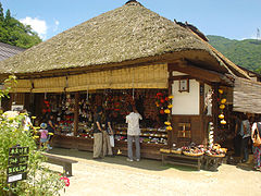
Soba shop


Web links
literature
- Fukushima-ken kotogakko chirirekishi kominka (shakaika) kenkyukai (Ed.): Ōuchijuku . In: Fukushima-ken no rekishi sampo. Yamakawa Shuppan, 2007. ISBN 978-4-634-24607-2 .
Coordinates: 37 ° 20 ′ 0 ″ N , 139 ° 51 ′ 38 ″ E