
Assebroek

Assebroek is a district of Bruges , south-east of the city center.
The place extended to 8.52 km² and had 19,473 inhabitants at the beginning of 2005.
history
Findings near the Sint-Lucas hospital (on display in the Gruuthuse Museum in Bruges) suggest that this region was already inhabited in the Stone Age. Aerial photos of the Meersen reveal an approximately 300 m wide ring of ditches and ramparts from the 5th century, where the Lords of Assebroek later built their castle.
Assebroek was independent until it was incorporated into Bruges in 1970.
photos
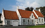
Former De Lelie inn (around 1661)

Web links
Commons : Assebroek - collection of images, videos and audio files
Coordinates: 51 ° 12 ' N , 3 ° 15' E