Camber Railway
The Camber Railway was a narrow-gauge railway (gauge 610 mm / 2 ft ) on the Falkland Islands . It was one of the southernmost railways in the world and was built to supply a radio station of the British Admiralty with coal for the generators. It ran over a length of 5.6 km along Stanley Harbor .
The line went into operation in September 1915. There were two two-axle steam locomotives of the "Wren" class supplied by Kerr, Stuart & Company .
The railway was shut down in the second half of the 1920s after the radio station was modernized; because the development of the amplifier tube made the originally used pop-spark transmitter superfluous, and much less energy was required than before. Some rails were installed in Argentine bunkers during the Falklands War in 1982 .
vehicles
- two steam locomotives of the "Wren" class: KS 2388/15 and 2392/15
- three wooden lorries
- a steam crane (on a flat wagon)
- Tilting lorries
- flat carts
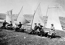
In the early 1920s, several carts were each fitted with a mast and a sail so that wind power could move in at least one direction. Some of these sailing lorries are featured on postage stamps from the Falkland Islands.
Individual evidence
- ↑ a b c d e The Falkland Island Express . Railways of the Far South. May 6, 2011. Retrieved January 2, 2015.
- ^ The Camber Railway at Stanley . Railways of the Far South. May 28, 2008. Retrieved May 22, 2015.
Web links
- The Falkland Island Express (extensive representation of the Camber Railway with numerous photos, English)
- Gustavo Adolfo Tamaño: Historias poco conocidas: Un ferrocarril en las Malvinas. (PDF (2.3 MB)) Soldados Digital, 2009, accessed on January 3, 2015 (Spanish).
Coordinates: 51 ° 40 ′ 58 ″ S , 57 ° 53 ′ 3 ″ W


