Curtis group
| Curtis group | ||
|---|---|---|
| Map of the archipelago | ||
| Waters | Bass Street | |
| Geographical location | 39 ° 29 ′ S , 146 ° 38 ′ E | |
|
|
||
| Number of islands | 3 | |
| Main island | Curtis Island | |
| Total land area | 1.49 km² | |
| Residents | uninhabited | |
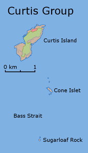
The Curtis Group ( English Curtis Group ) is an uninhabited archipelago in the northern Bass Strait about 40 km off the southern tip of mainland Australia . The islands belong to the Australian state of Tasmania .
The archipelago consists of three islands and numerous individual rocks. The main island is Curtis Island in the north, up to 220 m high and sparsely vegetated . The 90 m high Sugarloaf Rock forms the southernmost island in the group.
List of islands
![]() Map with all coordinates: OSM | WikiMap
Map with all coordinates: OSM | WikiMap
| Island name | Alias | Coordinates | surface | Residents |
|---|---|---|---|---|
| Curtis Island | 39 ° 28 ′ S , 146 ° 39 ′ E | 1.44 | - | |
| Cone Island | Cone Islet | 39 ° 30 ′ S , 146 ° 40 ′ E | 0.04 | - |
| Sugarloaf Rock | 39 ° 31 ' S , 146 ° 39' E | 0.01 | - |
Individual evidence
- ^ Curtis Group. In: geonames.org. Accessed May 31, 2020 (English).

