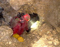
Theusseret cave
The Theusseret Cave (French: Grotte inférieure du Theusseret ) is a water-bearing horizontal cave around 750 m long with several siphons in the limestone layers of the Malm . It is located near the village of Goumois on the banks of the Doubs . The emergent hydrogeological conditions, d. H. the sudden, unpredictable changes in the water level almost led to tragedy in 1986. We strongly advise against visiting the cave by tourists who are unfamiliar with the cave, without special equipment ( wetsuits, etc.) or in unsafe weather.
Hydrogeology

The reasons for the fluctuating water levels are not precisely known. In any case, the cave entrance is rarely used for drainage and only briefly. Presumably the Theusseret drains into the stream at the level of the Doubs or from below into its stream bed.
1986 incident
In January 1986 two Basel cave explorers were surprised by suddenly rising water during a cave surveying tour when they were about 200 meters from the entrance. They could retreat to a higher place in the cave. Numerous cave rescuers , firefighters, the air ambulance and the canton police were on duty for two days to free the area. With the help of six powerful pumps, the water level was lowered to such an extent that the two trapped men could leave the cave unscathed after 40 hours of perseverance.
Individual evidence
- ^ Raymond Gigon, Villy Aellen, Rémy Wenger: Canton du Jura: Inventaire spéléologique de la Suisse II. Porrentruy 1986, p. 143.
- ^ Raymond Gigon, Villy Aellen, Rémy Wenger: Canton du Jura: Inventaire spéléologique de la Suisse II. Porrentruy 1986, p. 143.
- Jump up ↑ Raymond Gigon, Villy Aellen, Rémy Wenger: Canton du Jura: Inventaire spéléologique de la Suisse II. Porrentruy 1986, p. 144.
