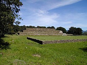
Huamango

Huamango is a pre-Columbian archaeological site in the northwest of the central Mexican state of Mexico .
location
Huamango was located on an old traffic route from the central Mexican highlands to the north of the country, almost 140 km (driving distance) northwest of the capital Mexico City at an altitude of approx. 2850 m . The next larger town is Acambay, about 6.5 km to the south-east, with about 4,000 inhabitants.
history
The place Huamango was settled in the period from about 900 to 1300 AD. Ceramic finds suggest that the Otomí tribe initially ruled; later the place was probably under the political and cultural influence of the city of Tula, about 70 km to the east . At the time of the military and political rise of the Aztecs in the 15th century, the site was already deserted, so that the Spaniards paid no attention to the place either. It was rediscovered around the middle of the 20th century and researched and partially reconstructed by the archaeologists Román Piña Chán and William Folan in the 1970s.
Archaeological site
The archaeological site, which was formerly enclosed by approx. 2 m high walls, consists of several terraces with remains of buildings. Most interesting today is a three-storey, previously plastered, step pyramid with a base area of approx. 40 × 40 m; the temple , which used to be riot, has disappeared.
literature
- William Folan: San Miguel de Huamango: un centro tolteca-otomí. In: Boletín de la Escuela de Ciencias Antropológicas de la Universidad de Yucatán Volume 6 (32) 1979, pp. 36-40.
- Román Piña Chán: Investigaciones sobre Huamango y región vecina (Memoria del Proyecto). 2 vols.Dirección de Turismo del Gobierno del Estado de México, Toluca 1981.
Web links
- Huamango - photo, video + quick info
- Huamango - Photos + Quick Facts (Spanish)
- Huamango - Photos + Info (INAH, Spanish)
Coordinates: 19 ° 58 ′ 39 ″ N , 99 ° 51 ′ 55 ″ W.