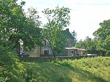
Kersland Manor House
Kersland Manor House was a manor house about 2.5 km northeast of Dalry in the Scottish administrative division of North Ayrshire . Nearby is the Garnock River .
history
The baronate
The barony Kersland was once extended, but by the time of Kerr's the land was divided. John Smith from Swineridgemuir bought the property after having owned the Kerr family for more than 500 years . In the 15th century the parish had four other baronates: Kelburne, Blair, Lynn and Pitcon . Kersland lay on the banks of the River Garnock and consisted of the properties Kersehead , Coalheugh-glen , Tod-hills , Brown-hills , Davids-hills and Auchengree , together about 280 hectares of arable land.
The mansion
The old mansion or old castle of Kersland stood on Easter Kersland Farm . The remains of the L-shaped Tower House were built into the farmhouse. The enclosure wall is still preserved and has a strong corner tower for defense. Paterson notes that the Tower House was almost completely demolished by the feudal lord Robert Ker . The two remaining chambers with vaulted ceilings and 2.4 meter thick walls, which later served as a milk room and stable, were until recently part of the offices of Easter Kersland Farm .
Above the front door of the house is a carved stone, which comes from the old manor house and bears the coat of arms of the Ker family and the inscription "Daniel Ker Kersland - 1604". This date stone was painted over. "Karrisland" is recorded on Timothy Pont's map around 1604, as are the place names "Karshead", "Todsle", "Dysil" and "Achingry". In 1685 the name "Carsland" appears. The property was surrounded by trees and had an orchard of considerable dimensions. Kersland Mains was on the Dalry driveway and became Wester Kersland Farm when the mansion was demolished.
Individual evidence
- ^ A b George Robertson: Topographical Description of Ayrshire, more particularly of Cunninghame: Barony of Kersland . P. 244. Retrieved January 4, 2017.
- ↑ Ayrshire Paths . Retrieved October 4, 2017.
- ^ Martin Coventry: Castles of the Clans . Goblinshead, Musselburgh 2010. ISBN 1-899874-36-4 . P. 307.
- ^ Martin Coventry: Castles of the Clans . Goblinshead, Musselburgh 2010. ISBN 1-899874-36-4 . P. 198.
- ↑ James Paterson: History of the Counties of Ayr and Wigton . Volume III: Cunninghame . Part 1 & 2. James Stillie, Edinburgh 1866. p. 184.
- ↑ East Kersland . Royal Commission on the Ancient and Historical Monuments of Scotland. Retrieved October 4, 2017.
- ↑ Cuninghamia / ex schedis Timotheo Pont; Ioannis Bleau excudebat. Cunningham . National Library of Scotland. Retrieved October 4, 2017.
- ↑ A mape of the west of Scotland Containing Clydesdail, Nithsdail, Rainfew, Shyre and Ayre, & Galloway / authore Jo Adair . National Library of Scotland. Retrieved October 4, 2017.
- ↑ James D. Dobie, JS Dobie (editor): Cunninghame, Topographized by Timothy Pont 1604-1608, with continuations and illustrative notices . John Tweed, Glasgow 1876. p. 250.
Web links
Coordinates: 55 ° 43 ′ 15.6 " N , 4 ° 41 ′ 48.5" W.


