List of landmarks on the English Channel
This list of landmarks on the English Channel (English Channel La Manche) called striking cities on the respective high banks, ports, lighthouses and other navigation points on the two coasts of the heavily used sea route English Channel , each from west to east. The approximately 550 km long Atlantic Strait between Great Britain in the north and France in the south is limited in the west by a line from the southwestern English headland of Land's End to the lighthouse of the French Île Vierge near Brest , according to the definition of the International Hydrographic Organization . In the east, the border with the North Sea runs along a line that connects the Shakespeare Cliff with the Cap Gris-Nez .
In the case of poor visibility in the region, shipping in the water was traditionally based on the long chain of prominent buildings or beacons to get to the safe harbors. Modern shipping follows radar-based sea routes ( traffic separation areas ) depending on the destination .
Internationally known port cities on the canal are Southampton , Plymouth and Dover in Great Britain and Cherbourg , Le Havre and Calais in France. In addition to London, practically all the major seaports in the Netherlands and Germany can be reached through its passage .

In this list, the places are enumerated along the north and south coast of the English Channel from west to east .
In the case of the older lighthouses , the year of first operation is noted in brackets. In the case of the municipalities, the type of use as a port can be mentioned. This can be particularly helpful in the search if a change in use has occurred (examples: container port, ferry port until 1968). Notable estuaries and landmarks are also mentioned.
Along the north coast from west to east
The north coast is part of the United Kingdom throughout. In the northwest, the Celtic Sea connects with Ireland's south coast.
Today Lizard Point in Cornwall is considered the north-west border point of the English Channel / British Channel. The brand is a little south of the 50th parallel.
Neighboring sea areas: Bristol Channel (English Bristol Channel; Welsh Môr Hafren) is a bay on the west coast of Great Britain between England ( Cornwall ) and Wales; Celtic sea
On the Scillys, from Land's End to Lizard Point
- Isles of Scilly (with the Bishop Rock lighthouse )
- Hugh Town (town on the Isles of Skilly)
- Trevescan
- Penwith peninsula
- Longships Lighthouse (tower 2.01 km off the coast on Carn Bras)
- Land's End , town
- Cape Cornwall (6.7 kilometers north of Land's End. This is where the Bristol Channel begins, as well as the Irish Sea to the north and the English Channel to the south . In the past, the headland was considered the westernmost point of England , until precise measurements showed that Land's End was the westernmost point is.)
- Porthcurno (submarine cable station)
- Mousehole (town with port)
- Penzance ; Penlee House (WWII Memorial and Penzance District Museum)
- Newlyn Harbor (fishing)
- St. Michael's Mount (small harbor, place of pilgrimage 400 m before Marazion )
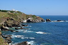
- Lizard Point near Helston ( beacon since 1619, various successors, The Lizard , also radio stations)
- Royal Naval Air Station Culdrose (RNAS Culdrose), the largest helicopter base in Europe
From Cadgwith to Plymouth
- Cadgwith
- Fowey (natural deep water harbor, an important base for pirates in the 15th century)
- Kuggar (Grade-Ruan, on the Lizard peninsula)
- Coverack (fishing port, cliffs nearby: The Manacles)
- Falmouth
- Portscatho (with Gerrans on Roseland Peninsula)
- Loooe
- Rame Head , in front of it Eddystone Lighthouse (1882; automated 1982; predecessor Winstanley's lighthouse, 1698)
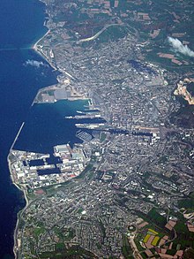
- Plymouth ( HM Naval Base Devonport , 1691, since then various extensions, largest naval base in Western Europe)
From Wembury to Exeter
On the south coast of Devon County
- Wembury
- Church Cove
- Ham Stone
- Starehole Bay
- Salcombe
- Start Point Lighthouse (in the South Hams District; 1836)
- Hellsands
- Dartmouth (dart)
- Brixham
- Exeter (seat of the British Meteorological Service, Met Office , which was in Bracknell until 2004 , international airport with scheduled flights also to the various islands)
- Exmouth
From Sidmouth to Portland
- Sidmouth
- Branscombe
- Beer
- Seaton
- Challaborough
- Bridport (Brid) and (2 km north of) West Bay , which was originally called Bridport Harbor
-
Isle of Portland (limestone quarries) near Weymouth , Dorchester
- Portland Bill Lighthouse
- Portland Harbor , Sandsfoot Castle (At 8.6 km², Portland Habour is one of the largest man-made harbors in the world. Expansion since 1849. During the Second World War, a large part of the Royal Navy was stationed at the now closed naval base.)
From Weymouth to Southampton
- Natural harbor at Poole
- Brownsea Island
- Canford Cliffs
- Bournemouth
- Christchurch (natural harbor)
- Barton on Sea
- Southampton (seat of Her Majesty's Coastguard since 1829)
Wight, from Portsmouth to Eastbourne
- Fire at the entrance to the Solent on Wight Island: Hurst Point Lighthouse and Needles Lighthouse (planned since 1781, in operation 1786)
-
Isle of Wight
- Norton Green
- Brightstone
- St. Catherine's Lighthouse (1323)
- Reef Bay
- St Lawrence
- Sandown Fort
- Culver Down Battery
- Bembridge
- St Helens Harbor
- East Cowes
-
Portsmouth ( Solent ) with the National Museum of the Royal Navy and Fort Nelson on Portsdown Hill (built after 1860)
- to the west is the port of Portsmouth (expansion since 1194)
- Portsmouth Harbor - Spinnaker Tower (new landmark, observation deck) on the sheltered west coast
- HM Naval Base Portsmouth on the Portsea Island peninsula
- Port fortifications including the Palmerston Forts, for example the Solent forts (built 1865–1880; now used as luxury hotels and a museum)
- Natural harbor to the east - Langstone Harbor. South of the Isle of Wight
- Before and during Normandy Landing 1944 SHAEF-HQ by Dwight D. Eisenhower (Southwick House)
- Gosport
- Selsey
- Worthing
- Brighton , known as the seaside resort ( resort Engl. Seaside)
- In 1497 a first fortification tower, repeatedly fortress / military base (Preston Barracks), expansion as a climatic health resort since the 1790s, 1823–1896 a landing stage made it possible to travel comfortably by steamship directly from London . Many hospitals in World War I , including the Royal Pavilion for Indian soldiers
- 2016, British Airways i360 , the highest observation tower in the UK at 173 meters, with a movable cockpit
- Newhaven Fort - expansion from 1865 (now a museum)
- Here are the westernmost Martello Towers on the south coast of England (now a museum).
- Beachy Head Lighthouse
- at the headland of the same name (highest chalk cliff in Great Britain at 162 m above sea level, part of the South Downs ). The tower was built in 1902 for better visibility in fog in front of the sea (43 m high). It is followed by the Seven Sisters called further striking cliffs. The name Beachy comes from the French Beauchef (beautiful cape). 1834 first lighthouse, the so-called Belle Tout Lighthouse, on a cliff 2 km further west.
- Eastbourne Pier , a 300 m long pier from 1872, as well as other piers. Fires; some reconstructions are in progress
- From 1890 expansion as an exclusive seaside resort, Bexhill-on-Sea. including the location of the first car race in Great Britain (1906)
From Hastings to Margate

- Hastings Castle , Hastings
- Greatstone
- Dungeness lighthouses ( Lydd region name )
- Folkestone (small harbor, northwest of the portal of the Eurotunnel )
-
Dover , Dover Castle (historically meaningful as "the key to England", with a Roman lighthouse), Port of Dover (formerly: Admiralty Harbor of Dover) and
- Dover Ferry Port
- Two South Foreland lighthouses (after 1840, first electric in 1859) mark the Downs
- Shakespeare Cliff (chalk cliffs by D.) (historical survey point with reference to Paris and Greenwich )
- at the narrowest point of the canal (33 km from France; from here the expression "Strait of D.")
- and Nort Foreland behind the Goodwin Sands range
- St Margaret's Bay
- Deal Castle , Naval Museum
- Stour Estuary, Richborough Port (Roman history and secret naval port, WW1)
- Ramsgate (hist. Lifeboat station) and the lifeboat station in Walmer , formerly the ferry port to Oostende, Vlissingen (Netherlands), Dunkirk (France) and Calais
- Margate
- Thanet offshore wind farm with 100 turbines in the sea
To the east and north the estuary of the Thames (English. Thames Estuary) z. B. with Rochester or the North Sea ( Doggerbank , Deutsche Bucht -German Bight).
Along the south coast from west to east
With the exception of the waters around the Channel Islands, the south coast of the canal is now part of France.
It includes northern Brittany and the Normandy coast with the Baie de Seine . The already mentioned archipelago of the Channel Islands is upstream. Historically, the name of Normandy is to be noted on both sides of the English Channel.
From Brest to Cherbourg
- Phare de Nividic rock and lighthouse (built from 1912, in operation with the war interruption since 1936)
- Island Ouessant (French), Breton Enez Eusa, English Ushant , is a French island in the Atlantic Ocean offshore to the west of mainland Brittany . With over 850 permanent residents, it is the westernmost settlement in France. There are 5 beacons here. The island belongs to the Brittany region, the Finistère department, the Brest arrondissement and the Saint-Renan canton.
- The Phare du Créac'h , in Breton Tour-tan ar C'hreac'h and in English. Ushant Lighthouse from 1863, the radar tower and the Phare du Stiff in the northwest of the island are used to monitor the western part of the traffic separation area in the canal. There is also a transmission mast for the NAVTEX system and the Musée des phares au Créac'h .
- Brest in the department of Finistère (this is translated as the end of the earth and locally means head / head of the earth)
- Phare de l'Île Vierge (construction started in 1842; near Plouguerneau )
- Île-de-Batz (lighthouse)
- Lannion
- Morlaix
- Saint-Malo (Rance with the Usine marémotrice de la Rance tidal power station , 1966)
- Harbor and fortress, bay of the same name
- Tombelaine (rock island) and Le Mont-Saint-Michel (with parish and monastery / abbey ; northwest of Avranches )

- Saint-Pair-sur-Mer
- Granville
- north of it lies: the Cotentin peninsula
- Coutances
- Barneville-Carteret
- Floorboard
- Channel Islands (English Channel Islands, French Îles Anglo-Normandes), a group of islands in the southwestern part of the English Channel - near the coast of the French department of Manche. About 166,000 people live on them (as of 2015):
- Jersey (southernmost Channel Island , British)
- guernsey
- Saint Peter Port , port of the
- Capital and main port city of Guernsey (British Channel Islands )
- Castle Breakwater Lighthouse, Saint Peter Port Harbor (1850's)
- Brehon Tower , Little Roussel , Guernsey (1856)
- Les Hanois Lighthouse , Les Hanois , Guernsey (1862)
- Reefs west of the island
- Sark
- about 1.5 kilometers west of Alderney (to Guernsey)
- Alderney
- North access to the Passage de la Déroute in the Gulf of Saint-Malo (with the road from Alderney or Raz Blanchard - designation of the sea routes)
- Flamanville (Dépt. Manche)
- Port: Port-Diélette; Semaphore (1867–1988)
- Flamanville nuclear power plant (in operation since 1985; central nucléaire; new block: EPR )
- Le nez de Jobourg and Le cap de la Hague as north-west. Beginning of Normandy
- CROSS-ma Jobourg (French navy radar station)
- Auderville
- Cherbourg-en-Cotentin (war and trading port;
- Roman castrum, in 1688 S. de Vauban began to build fortifications; 2002 La Cité de la Mer Museum )
- Harbor and Phare de Gatteville on Pointe de B. after 1775
From Bayeux to Honfleur
The Bay of the Landing Beaches 1944 , geographical name Baie de Seine after the river mouth. In French the cinq plages du débarquement allié en Normandie , for details on the sections / Secteur américain see under Utah Beach , Omaha Beach and the Secteur anglo-canadien with Gold Beach , Juno Beach and Sword Beach (also French troops; between Ouistreham and Saint- Aubin-sur-Mer).
- Gatteville-le-Phare , tower after 1775, second tower in 1896; at Barfleur
- La Madeleine (district of Sainte Marie du Mont; Utah Beach)
- Carentan
- Saint-Lô

- Bayeux
- Huppain with Port-en-Bessin-Huppain
- Graye-sur-Mer
- Courseulles-sur-Mer (1944 Juno Beach ; distinctive church tower)
- Saint-Aubin-sur-Mer
- Caen
- Ouistreham , Orne Estuary, Sword Beach
- Sallenelles
- Merville-Franceville-Plage
- Varaville
- Cabourg
- Houlgate
- Villers-sur-Mer
- Blonville-sur-Mer
- Tourgéville
- Benerville-sur-Mer
- Deauville (Vieux Port, Port Deauville )
- Trouville-sur-Mer
- Villerville
- Honfleur , Musée de la Marine (in the Saint-Étienne church)
From Le Havre to Boulogne
- Le Havre , to the east follows the Pays de Caux
- Saint-Jouin-Bruneval with the oil port of Port du Havre-Antifer, which is important for France (striking circular basin)
-
Étretat , known are the cliffs (Falaises d'É., Cliffs of Etretat)
- Falaises d'Aval (75 m)
- Falaises d'Amont (84 m)
- Fécamp (cliffs 105 m high)
- Hautot-sur-Mer (Sci)
- with a German military cemetery for Canadians who died in August 1942 (Cimetière militaire canadien de Dieppe)

- Le Tréport
- Saint-Valery-sur-Somme
- Le Crotoy
- Baie d'Authie
- Berck
- Étaples
- Boulogne-sur-Mer ( Liana )
- Lighthouse on the Cap Gris-Nez
- well-known landmark on the Côte d'Opale for the Strait of Dover (French: Le pas de Calais, English: Strait of Dover or Dover Strait: narrowest point). The term "gray" arose because the exposed rock is gray, in contrast to the Cap Blanc-Nez in sight to the north, where white chalk rock comes to light.
From Calais to Ostend
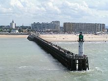
- Calais (Roman Caletum; Pale of Calais until 1558; Tour de Guet - since the 13th century - possibly even 810; new lighthouse 1848 - Le phare de Calais, 55 m high, electrified in 1883, automated in 1992; important ferry port)
- Marck ( Phare de Walde , 11 m high, 1857; closed)
- Gravelines (with the Avantport Ouest)
- Grande-Synthe (Bourbourg)
- Dunkerque (Dunkirk) (city wall 960, expansion of the fishing port into Grand port maritime de Dunkerque from the 11th century, port museum ; belfry (Beffroi) , tower, 58 m; UNESCO entry)
- Ostend (Belgium) ( NAVTEX station (Navarea 1, sea warning area North Sea / North Atlantic); ferry port)
Movies
- Xavier Lefebvre: The most beautiful coasts of France. (French original title: La France par la côte) tv series, documentation, France (arte), 2009, ten parts each 43 min. IMDB ; mostly helicopter aerial photographs.
- Part 1: From Dunkirk to the Seine estuary.
- Part 2: From Honfleur to Mont-Saint-Michel.
- Part 3: From Cancale to Ile d'Ouessant. (Brest)
literature
- John Hendy: Dover-Calais: The Short-Sea Route . Ferry Publications, Ramsey, Isle of Man 2009, ISBN 978-1-871947-93-9 .
See also
Web links
- The Commons picture collection has chapters on: English Channel - ►Coast Normandy - ►Coast in Ver. Kingdom - ► Coast in France
- Peter Dominiczak, Robert Mendick, Martin Evans, Rory Mulholland: Royal Navy must be deployed in Channel to protect against terrorists and people smugglers, MPs warn ( Küstenschutz durch die Navy? Vs. armed sea marshals. In: telegraph.co.uk from 3 . Aug. 2016)
Individual evidence
- ^ Limits of Oceans and Seas, IHO, 3rd Edition, 1953
- ↑ Compare the informative article coastline of the ... at en: WP (English)
- ↑ Geography and Maps … for the English north coast of the Canal, Ordnance Survey
- ↑ Met Office - Homepage (compare English Sea Weather Service , English Shipping Forecast)
- ^ History of the Solent forts . Royal Naval Museum. Archived from the original on July 12, 2018. Retrieved July 12, 2018.
- ↑ This is also the case with a painting by John Constable “Chain Pier, Brighton” from 1826
- ↑ Complete list of The Seaside resorts in Ver. kingdom
- ↑ 2017 film


