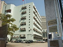
Morrison Hill

Morrison Hill ( Chinese 摩 理 臣 山 , Pinyin Mólǐchén Shān ) is an urban area between Wan Chai and Happy Valley , on Hong Kong Island in Hong Kong . Originally the area was a hill.
history
Until the Praya East Reclamation Project was carried out in the 1920s, the hill was on the seashore. The land reclamation project used soil and rocks to gain new building ground in the port and to drive the coastline further into the bay. Over a decade, the ground was cleared and even temporary light railways built that ran along the Bowrington Canal (now Canal Road ). The canal was covered for this purpose.
The hill was originally named after the Protestant missionary and linguist Dr. Robert Morrison , who was active in the area through his Morrison Education Society .
Development
Today, the center of the district is taken by the Morrison Hill Swimming Pool , as well as several secondary schools within a ring road, Oi Kwan Road ( Chinese 愛 群 道 ). A main street, the Morrison Hill Road ( Chinese 摩理臣山道 ), runs along the east side of the quarter. The Queen Elizabeth Stadium and Tang Shiu Kin Hospital are on the southern edge. There is also a skate park by the playground to the southeast.
Buildings
Hospitals :
Educational institutions :
- Hong Kong Institute of Vocational Education (Morrison Hill) (with the headquarters of Vocation Training Council by its side),
- Lady Trench Training Center
- Tang Shiu Kin Victoria Government Secondary School
- Sheng Kung Hui Tang Shiu Kin Secondary School
Other important institutions :
- The Scout Association of Hong Kong Regional Headquarters
- Tang Shiu Kin Social Service Center
- Ammar Mosque and Osman Ramju Sadick Islamic Center
Individual evidence
- ↑ 1920s Excavation of Morrison Hill , Gwulo.
- ↑ Valery Garrett: Elizabeth Sinn (Ed.): Dictionary of Hong Kong Biography . Hong Kong University Press, 2011, p. 329.
- ^ WH Carey: Oriental Christian Biography, Containing Biographical Sketches of Distinguished Christians Who Have Lived and Died in the East . Calcutta, Baptist Mission Press, 1850, p. 193.
Web links
Coordinates: 22 ° 16 ′ 31.4 " N , 114 ° 10 ′ 46.9" E


