
Azimuthal orthographic projection

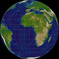
The orthographic azimuthal projection is a map projection in which the (earth) surface is mapped onto a plane by parallel projection. A maximum of one hemisphere can be displayed with this projection. It is neither true to area nor angle, but quite clear, as it shows the surface as it would be seen from (infinitely) great distance "from space". It maps along the concentric circles around the center point (circles of latitude with polar projection) true to length.
This projection is often used for lunar and planetary maps. In particular, the moon, which always shows us the same side, is depicted as it is seen from the earth. The oblique projection (centered neither on the pole nor on the equator) is often used for picture postcards and other descriptive representations of the earth.
Transverse projection

Polar projection

Leaning projection, centered on Japan

